The National Weather Service forecasts for the United States from December 9 to 13 indicate that national temperatures will be close to or above normal levels, with the northern plains and states along the atlantic china welding consumables,inc. likely to experience warmer than normal weather.
Here are the agriculture weather tips for the USA on Wednesday, December 4, 2024, exclusively compiled by the Jinshi futures APP.
Western United States Cool and rainy weather extends from the northwestern Pacific to the northern Rockies. This rain is beneficial for crops in the northwest, including winter wheat and small grains sown in the spring. At the same time, the hot weather in the Southwest is beneficial for farming and crop growth, although there is a high wildfire threat in some areas of Arizona and New Mexico.
In the western region, the weather is dry, with temperatures close to or above normal levels, favorable for fieldwork, especially late-season harvesting activities in California and the desert southwest. Today's high temperature in California's Sacramento Valley is expected to reach 70°F, while some areas of the desert southwest may approach 80°F. However, in the northwest, especially in Oregon, southwestern Idaho, and western Nevada, there are still issues with air stagnation and freezing fog.
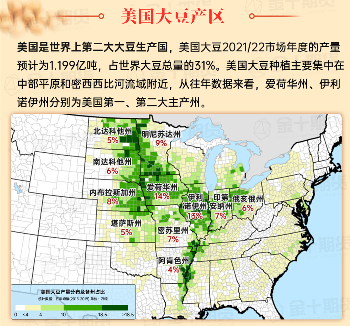
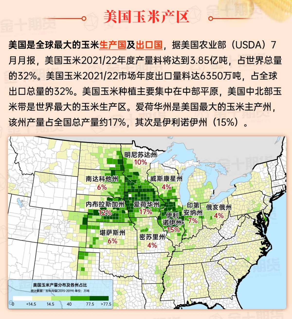
Corn Planting Area of the United States Showers and a few thunderstorms extend southwest from the Upper Midwest. At the same time, warm and mostly dry weather in the eastern corn belt is favorable for late-season corn and soybean planting, as well as winter wheat growth.
 In the Great Plains region, temperatures have risen to close to or above normal levels, except for some areas of Montana and North Dakota. Today's high temperatures in the southern plains are expected to range from 55 to 70°F, favorable for the further development of winter wheat, particularly in areas where planting and emergence have been delayed due to drought in September and October.
Weather Outlook Initially, the active weather in most parts of the United States will eventually consolidate along the cold front sweeping through the central United States on Tuesday. Subsequently, the cold front will reach the coastal states along the Atlantic Ocean on Thursday, although cool and unstable showers will persist in the Great Lakes states for a few days. According to preliminary reports, the United States will breathe a sigh of relief from the continuous thunderstorms that triggered more than 500 tornadoes in May. Before calm weather arrives, precipitation in the eastern half of the United States may reach 1 to 3 inches, except in the southern hinterland. In addition, early heat waves will expand in the western United States this weekend, with maximum temperatures exceeding 110 degrees Fahrenheit and covering lower altitude areas in the desert southwest.
In the corn belt region, light snowfall is limited to the Great Lakes area. Other areas will be mainly characterized by windy weather due to the approach of a cold front. Despite the strong winds, many Midwestern producers are still taking advantage of relatively open weather for farm maintenance and other off-season activities.
Map of US Corn Production Areas
In the southern region, rain showers have appeared in eastern Texas and Louisiana. Cool and dry weather covers the rest of the southern area, and frost occurred again in northern Florida this morning. However, the key winter agriculture areas in Texas and Florida have avoided temperatures below freezing during this week's cold wave.
Chicago SRW Wheat and Corn Futures
A low pressure system currently located north of Lake Superior is moving quickly eastward and is expected to reach northern New England by Thursday. Light snowfall associated with the system will affect the Midwest and Northeast, with possible snow showers in the storm's trailing wake over the Great Lakes region. Rainfall along the cold front trailing the storm may total 1 to 2 inches along the western Gulf Coast in the coming days. A subsequent storm system will affect the same area over the weekend, resulting in a total rainfall of 2 to 6 inches from eastern Texas to the Mississippi Delta over five days. Apart from unstable weather in the northwest region over the weekend, the rest of the area will mostly remain dry. Furthermore, cold weather impacting much of the Midwest and East will ease before the weekend.
The National Weather Service's 6-10 day outlook from December 9 to 13 predicts that temperatures across the USA will be near or above normal, with the northern plains and states along the atlantic china welding consumables,inc. most likely to experience warmer than normal weather. Meanwhile, precipitation across much of the western and central regions is expected to be near or below normal, contrasting with wetter conditions along the Gulf Coast, one-third of the eastern USA, and near the Canadian border.
Soybeans should be translated as soybean.

The Atlantic Ocean should be translated as the Atlantic.

Cotton should be translated as cotton.


 在大平原地区,气温已回升至接近或高于正常水平,蒙大拿州和北达科他州部分地区除外。今日南部平原地区的最高气温预计在55至70°F之间,有利于冬小麦的进一步发展,尤其是在9月和10月干旱导致种植和出苗延迟的地区。