
 干燥的天气和高于正常的温度有利于夏季作物成熟和收获,以及冬小麦种植。今天南部平原地区的最高温度将达到100°F,并且应该在南达科他州西部以北的地区超过90°F。在蒙大拿州,截至9月15日,已有23%的计划种植冬小麦面积完成种植,最近的表层土壤湿度增加有利于作物出苗。
The 6-10 day outlook from the National Weather Service in the usa from September 25th to 29th shows that temperatures nationwide are generally above normal, with the northern and western usa most likely to experience warmer than normal weather.
The following is the agricultural weather forecast for the United States on Friday, September 20, 2024, exclusively compiled by the Golden Ten Futures App.
Western United States Cool and rainy weather extends from the northwestern Pacific to the northern Rockies. This rain is beneficial for crops in the northwest, including winter wheat and small grains sown in the spring. At the same time, the hot weather in the Southwest is beneficial for farming and crop growth, although there is a high wildfire threat in some areas of Arizona and New Mexico.
The dry weather continues to promote field operations, including the harvesting of summer crops and the planting of winter wheat in the northwest. Meanwhile, although wildfires in the United States have destroyed over 7.3 million acres of vegetation so far this year, far exceeding the 10-year average of 5.9 million acres, fire activity in the West has generally decreased in recent days.
Corn Planting Area of the United States Showers and a few thunderstorms extend southwest from the Upper Midwest. At the same time, warm and mostly dry weather in the eastern corn belt is favorable for late-season corn and soybean planting, as well as winter wheat growth.
 Dry weather and above-normal temperatures are beneficial for the maturation and harvesting of summer crops, as well as winter wheat planting. Today, the highest temperature in the Southern Plains region will reach 100°F, and it should exceed 90°F in areas north of western South Dakota. In Montana, as of September 15th, 23% of the planned winter wheat planting area has been completed, and the recent increase in topsoil moisture is favorable for crop emergence.
Weather Outlook Initially, the active weather in most parts of the United States will eventually consolidate along the cold front sweeping through the central United States on Tuesday. Subsequently, the cold front will reach the coastal states along the Atlantic Ocean on Thursday, although cool and unstable showers will persist in the Great Lakes states for a few days. According to preliminary reports, the United States will breathe a sigh of relief from the continuous thunderstorms that triggered more than 500 tornadoes in May. Before calm weather arrives, precipitation in the eastern half of the United States may reach 1 to 3 inches, except in the southern hinterland. In addition, early heat waves will expand in the western United States this weekend, with maximum temperatures exceeding 110 degrees Fahrenheit and covering lower altitude areas in the desert southwest.
A weakening cold front is producing some showers, mainly in the Great Lakes region. However, much of the central and western regions remain warm and dry, with today's high temperatures expected to range widely between 80 and 95°F. Due to the continued warm and dry weather, topsoil moisture has been depleted, and corn and soybeans are being rapidly harvested.
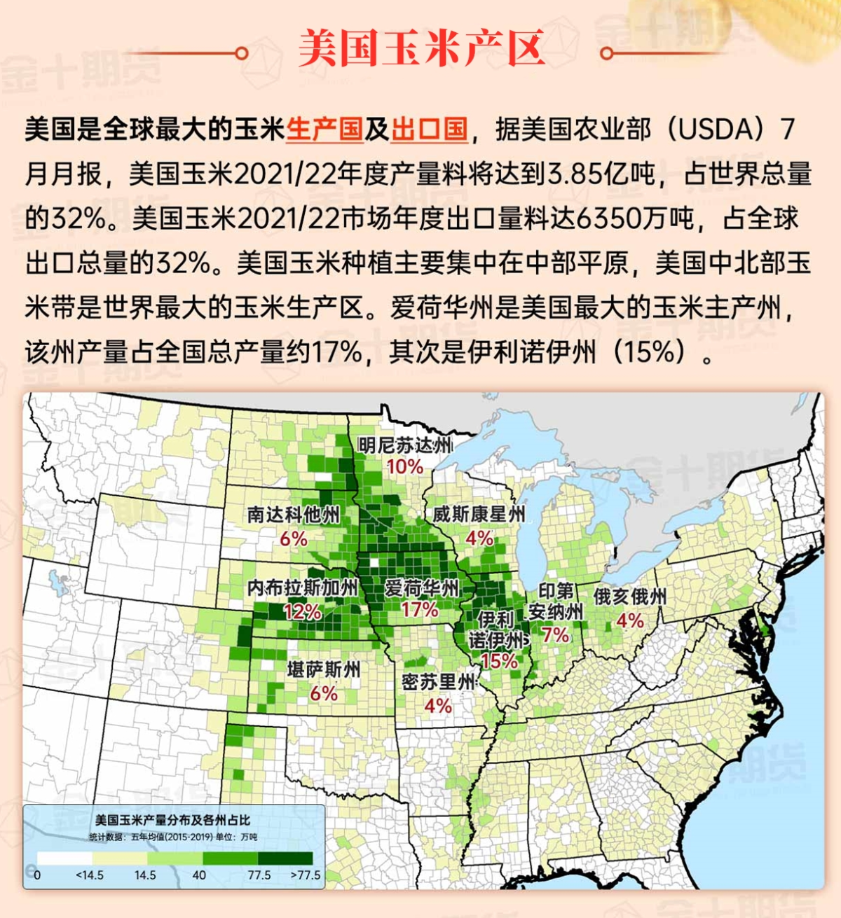
Map of US Corn Production Areas
Warm, dry weather prevails, with any sustained showers confined to the Florida Peninsula. Following the recent rainfall brought by Hurricane Francis and potential Tropical Cyclone Eight, soil moisture conditions in the southern region have improved.
Chicago SRW Wheat and Corn Futures
A disturbance currently crossing the western United States will become more active over the weekend, resulting in a 5-day precipitation total of 1 to 3 inches from the central and southern regions of the Rockies and Plains to the southern and eastern Corn Belt and down to the five Great Lakes states. However, dry weather will dominate in most parts of the United States, including the northern Plains, upper Midwest, southern, and much of the western regions. Late season heat associated with southern drought - with high temperatures generally exceeding 90°F - meanwhile, the Pacific coastal states and the southwest deserts will experience above-normal temperatures. Elsewhere, the Atlantic Basin should remain active, with the possibility of a tropical cyclone development in the northwestern Caribbean Sea or Gulf of Mexico early next week.
The 6-10 day outlook from the National Weather Service from September 25th to 29th shows temperatures nationwide generally above normal, with the northern and western regions most likely to experience warmer than normal weather. Meanwhile, much of the area from the Pacific coast to the Plains and Midwest will see near or below normal precipitation, compared to areas east of a line from Louisiana to Lake Erie, where rainfall will be above normal.
Soybeans should be translated as soybean.
The Atlantic Ocean should be translated as the Atlantic.
Cotton should be translated as cotton.
