Find Your Next Adventure With the Rugged Tread 2 Powersports Navigator From Garmin
Find Your Next Adventure With the Rugged Tread 2 Powersports Navigator From Garmin
OLATHE, Kan./November 5, 2024/PR Newswire – Garmin (NYSE: GRMN) today announced the rugged Tread 2 off-road navigator that guides adventures on dirt, snow and everything in between. Purpose-built for snowmobile, side-by-side, ATV, UTV and motorcycle enthusiasts, the next-gen Tread 2 features an ultrabright 6-inch touchscreen display, turn-by-turn navigation, topographic maps and more to enhance any journey. Additionally, Garmin announced the new Handlebar Controller (sold separately) that offers riders more convenient navigator control from their handlebars.
OLATHE,堪薩斯州/2024年11月5日/PR Newswire – 佳明(紐交所:GRMN)今日宣佈推出強悍的Tread 2越野導航儀,可指引冒險者穿越泥濘、積雪以及各種地形。專爲雪橇、側聯式車輛、ATV全地形車、UTV多用途車輛以及摩托車愛好者定製的下一代Tread 2配備超亮6英寸觸摸屏顯示屏、逐步導航、地形圖等功能,可增強任何旅程。此外,佳明還宣佈推出新的車把控制器(需另行購買),爲騎手們提供更便捷的導航控制功能。
"We created the Tread 2 for our off-road customers who never back down from a challenge. Built tough, the device is designed to guide you through all types of conditions and stand up to extreme weather. It also comes packed with a wide range of mapping options, giving adventure seekers confidence to take the path less traveled." –Dan Bartel, Garmin Vice President of Global Consumer Sales
「我們爲那些永不退縮於挑戰的越野客戶打造了Tread 2。設計堅固,該設備旨在引領您穿越各種條件並經受極端天氣考驗。它還裝載了各種廣泛的地圖選項,讓冒險尋求者有信心選擇不一樣的道路。」 – 丹·巴特爾,佳明全球消費銷售副總裁
Roam the unknown with Garmin's Tread 2.
用佳明的Tread 2徜徉未知領域。
Rugged design
堅固設計
Tread 2 brings adventure to life with a 6-inch high-resolution, ultrabright display, which is easy to view in direct sunlight and easy to operate while wearing gloves. It has an IP67 dust/water rating to withstand weather and demanding terrain. Travel confidently across tough terrain using built-in sensors that include an altimeter, barometer, compass and pitch/roll gauges. Additionally, Tread 2 includes rugged roll tube and handlebar mount options to best fit the setup of a wide range of powersport vehicles.
Tread 2通過6英寸高分辨率、超亮的顯示屏給冒險增添生機,在強陽下易於查看,戴手套操作也很方便。它擁有IP67級的耐塵/防水評級,可以抵禦惡劣天氣和苛刻地形。利用內建傳感器,包括高度計、氣壓計、指南針以及俯仰/滾轉儀表,安心穿越崎嶇地形。此外,Tread 2還配備堅固的滾筒和車把支架選項,以最佳方式適配多種戰力車輛的配置。
Superior mapping
卓越地圖
The Tread 2 offers an incredible assortment of mapping features to help adventurers push their limits and explore with greater confidence.
Tread 2提供令人難以置信的各種地圖功能,幫助冒險者突破極限,更有信心探索。
- Off-road mapping: Find the way with turn-by-turn navigation for unpaved roads and trails with content from OpenStreetMap, U.S. Forest Service Motor Vehicle Use Maps and Adventure Roads and Trails1.
- Maps for snowmobiles: Explore with preloaded topographic maps, plus snowmobile-accessible trails and locations throughout the northern U.S. and all of Canada.
- Satellite imagery: Download subscription-free satellite imagery directly to the device via Wi-Fi technology to see high-resolution overhead views of routes and terrain.
- Federal Public Land Boundaries: Be aware of public land boundaries for national forests, Bureau of Land Management and wilderness areas and view private land boundaries and landowner information for parcels greater than four acres.
- Live updates: Use the Tread mobile app on a compatible smartphone with an active cellular or Wi-Fi connection to access live weather; share GPX files of favorite routes and track friends' real-time locations using the Group Ride2 mobile feature.
- On-road mapping: When the adventure stays on paved roads, follow them with preloaded City Navigator maps of North America.
- Outdoor Maps+: Purchase a subscription to Outdoor Maps+ to access premium map content, including slope angle, hunting data, avalanche risk reports, and more.
- 越野地圖:通過OpenStreetMap、美國森林管理局機動車使用地圖以及探險道路和小徑,爲未鋪裝道路和小徑提供逐步導航。
- 雪地摩托車地圖:探索預裝的地形地圖,以及貫穿美國北部和加拿大所有雪地的雪地摩托車通道和位置。
- 衛星影像:通過Wi-Fi技術直接在設備上下載免費訂閱的衛星影像,查看路線和地形的高分辨率俯視圖。
- 聯邦公共領地邊界:了解國家森林、國土管理局和荒野地區的公共領地邊界,並查看四英畝以上地塊的私人土地邊界和土地所有者信息。
- 實時更新:使用兼容智能手機上的Tread移動應用,並配有活躍的蜂窩或Wi-Fi連接,獲取實時天氣;使用Group Ride2移動功能分享喜愛路線的GPX文件,並跟蹤朋友的實時位置。
- 在路地圖:當冒險保持在鋪設的道路上時,請使用預裝的北美 City Navigator 地圖跟隨它們。
- Outdoor Maps+:購買Outdoor Maps+訂閱以訪問高級地圖內容,包括坡度角度、狩獵數據、雪崩風險報告等。
Control from the handlebar
從手柄控制
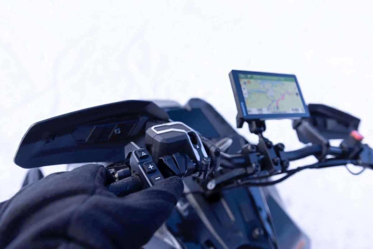
Adventure-seekers can easily operate their compatible Tread or zūmo XT2 navigators with the new, wired Handlebar Controller (sold separately). The controller lets riders zoom in and out of their map view, select and scroll through their preferred map layers, waypoints, control music and more. And the intuitive push-button design makes it easy to operate the controller without removing gloves or other gear.
冒險者可以輕鬆地使用新的有線手柄控制器(單獨出售)操作其兼容的 Tread 或zūmo XT2 導航器。該控制器可讓騎手放大和縮小地圖視圖,選擇和滾動其喜愛的地圖圖層、航點、控制音樂等。直觀的推按鈕設計使得騎手可以在不脫手套或其他裝備的情況下輕鬆操作控制器。
The handlebar controller includes versatile mounting options to fit most snowmobiles, motorcycles and ATVs. It can also withstand adventurous rides with an IP67 dust and water-resistance rating, while the wired power source ensures reliable performance in extreme temperatures.
方向盤控制器包括多種安裝選項,適合大多數雪地摩托車、摩托車和ATV。它還可以承受冒險騎行,具有IP67防塵防水等級,有線電源確保在極端溫度下可靠運行。

Working together
協同合作
Riders can stay connected when venturing beyond cellphone coverage by pairing a compatible inReach SOS satellite communication device3 for two-way messaging – which includes voice and photo messaging on select devices – and location tracking via the 100% global Iridium satellite network. In the event of an emergency, users can send an interactive SOS message to Garmin ResponseSM, a 24/7-staffed international emergency assistance coordination center.
騎手在超出手機覆蓋範圍時可以保持連接,通過配對兼容的inReach SOS衛星通信裝置3進行雙向消息傳遞 – 在某些設備上包括語音和照片消息 – 並通過100%全球艾裏迪亞姆衛星網絡進行位置追蹤。在緊急情況下,用戶可以向佳明ResponseSm發送互動式SOS消息,這是一個全天候運作的國際緊急援助協調中心。
Adventure seekers can also stay in touch with members in their group by pairing Tread 2 with the Group Ride Radio for location sharing and voice communication through the push-to-talk mic when exploring outside of cell coverage. Additionally, it pairs with a Bluetooth enabled helmet or headset for hands-free communication.
冒險追求者還可以通過將Tread 2與Group Ride Radio配對,與團隊成員保持聯繫,以便在手機覆蓋範圍外探險時通過按鍵對講麥克風進行位置共享和語音通信。此外,它還可以與藍牙耳罩或耳麥配對,實現免提通信。
Available now, the Garmin Tread 2 has a suggested retail price of $699.99, while the new Handlebar Controller has a suggested retail price of $149.99. Visit our website to learn more.
現在可以購買Garmin Tread 2,建議零售價爲$699.99,而新的手柄控制器的建議零售價爲$149.99。請訪問我們的網站了解更多信息。
Engineered on the inside for life on the outside, Garmin products have revolutionized life for adventurers, athletes, off-road explorers, road warriors and outdoor enthusiasts everywhere. Committed to developing products that enhance experiences, enrich lives and help provide peace of mind, Garmin believes every day is an opportunity to innovate and a chance to beat yesterday. Visit the Garmin Newsroom, email our media team, connect with @garminoutdoor on social, or follow our blog.
佳明的產品從內到外都是爲了戶外生活而設計的,已經徹底改變了很多冒險家、運動員、越野探險家、公路戰士和戶外愛好者們的生活方式。致力於開發能夠提高用戶體驗、豐富生活、幫助提供安心感的產品,佳明相信每一天都是一個創新的機遇,也是超越昨天的機會。訪問佳明新聞中心、通過電子郵件與我們的媒體團隊聯繫、在社交媒體上關注@garminoutdoor,或關注我們的博客。
1Limitations may exist in map data for some road and trail route suggestions. Always defer to posted road signs and conditions during vehicle operation. Garmin products using OpenStreetMap data are intended to be used only as supplementary travel aids.
1. 在部分道路和小徑路線建議的地圖數據中可能存在限制。在車輛行駛過程中,請始終遵循張貼的道路標誌和條件。使用OpenStreetMap數據的佳明產品僅用作輔助旅行工具。
2Tracking via Group Ride Mobile requires the Tread app running on each party's compatible smartphone with Bluetooth technology and an active cellular connection.
通過團隊騎行移動應用進行跟蹤需要在每個參與方兼容的智能手機上運行Tread應用,具有藍牙技術和活動的蜂窩連接。
3An active inReach subscription is required. Some jurisdictions regulate or prohibit the use of satellite communication devices. It is the responsibility of the user to know and follow all applicable laws in the jurisdiction where the device is intended to be used.
需要激活inReach訂閱。有些司法管轄區規定或禁止使用衛星通信設備。用戶有責任了解並遵守在設備擬在使用的司法管轄區中適用的所有法律。
譯文內容由第三人軟體翻譯。

