


 从内布拉斯加州向南,因风速达到每小时40到60英里或更高,加上低湿度和充足的干燥燃料,广泛存在野火威胁,即使在上周有降水的地区也是如此。同时,南部平原的部分地区仍在评估和恢复上周五大风事件造成的损失,该事件导致了扬尘和多起快速蔓延的野火。

The weather conditions in various parts of the USA are complex and changeable, with threats from storms and wildfires intertwined. How will the weather in the coming days affect Agriculture production?
The following is the Agriculture weather advisory for the USA on Monday, March 17, 2025, exclusively compiled by the Jinshi Futures APP.
Western Region
On March 17, a precipitation band appeared in the western region from Northern California to Montana, with late-season snowfall in high elevations further improving the prospects for spring and summer runoff; this area has already experienced ample winter storms. At the same time, dry, warm weather has returned to the desert southwest.
Great Plains Region
 From Nebraska southward, widespread wildfire threats exist due to wind speeds reaching 40 to 60 miles per hour or higher, along with low humidity and ample dry fuel, even in areas that saw precipitation last week. Meanwhile, parts of the southern plains are still assessing and recovering from the damage caused by last Friday's strong wind event, which resulted in dust storms and multiple rapidly spreading wildfires.
Corn Belt Region
In the Corn Belt region, cold weather east of the Mississippi River persists after the departing storm system. However, warm weather is quickly returning to parts of the western Corn Belt, with today's high temperatures reaching 80 degrees Fahrenheit, north to the mid-Missouri River. Last Friday's severe weather outbreak resulted in scattered wind damage across the Midwest and several tornadoes between Missouri and Indiana.
Southern region
In the southern region, a strong cold front is moving away from the Atlantic coast. Previously, severe weather outbreaks from March 14 to 15 triggered dozens of tornadoes, many of which struck the central and southeastern areas. Currently, cool and windy weather has covered the areas affected by tornadoes, and recovery efforts are ongoing. In the southeastern inland areas where rainfall reached 3 to 6 inches or more, field operations are still delayed.
Outlook
A rapidly moving storm system will maintain windy weather across much of the USA, resulting in a continued wildfire threat in the central and southern regions, sometimes extending to the central plains. Over the next 5 days, dry weather will persist from the desert southwest to the western Gulf Coast, but more northern areas will experience varying degrees of precipitation. In fact, significant snowfall is expected in the mountainous regions of the western USA during the first half of this week, as far south as the Sierra Nevada and central Rocky Mountains. Subsequently, a mid-week snow band will cover areas from Nebraska to Lake Superior. Additionally, localized severe thunderstorms may reappear starting from the eastern Mississippi River Valley.
The National Weather Service's 6 to 10-day weather outlook from March 22 to 26 shows that temperatures across the USA will be near or above normal levels, with California and the desert southwest most likely to experience warmer-than-normal weather. Meanwhile, precipitation across much of the USA will be near or above normal, contrasting with the dry weather from central and southern California to the southern high plains.
Map of USA Soybean production areas.
Map of USA Corn production areas.
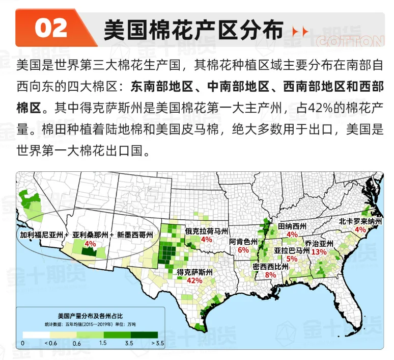
Map of Cotton production areas in the USA.


 Today, after hitting the high near 24,000 in the early session and entering bearish positions, the index fell sharply by nearly over 600 points, immediately recouping yesterday's losses significantly.

 Moreover, today it broke the new high again, reaching a maximum of 24,076, but by the end of the market, it fell back by about 70 points, producing a bearish candle. The current trend has not yet been broken, but from the previous low until now, it has risen close to 6,000 points. It is believed that those with positions can continue to hold until there is a clear trend reversal for profit-taking. Those without positions can wait for a pullback to get in. Actually, it is hoped for a quick pullback, as it allows for entry and also provides a healthy breath.
 Currently, the outlook remains the same as before. It is believed that even if there is a pullback, it shouldn't be too deep. However, if Futures fail to stabilize and close below 22,350, there may still be room for decline. The chance of Futures falling below 21,400 in the short term should be low, so it is considered that if a significant pullback occurs, it presents a good opportunity to incrementally go long. Recently, there has been a consistent approach to not hold positions overnight, only focusing on immediate trades, as there is no high chasing and no casual short selling.
Comment(0)
Reason For Report