The National Weather Service's outlook for the USA from January 11 to January 15, 2025, indicates that temperatures in most areas of the country are expected to be near or below the normal levels.
The following is the USA Agriculture weather advisory for January 6, 2025, Monday, exclusively compiled by the Jinshi Futures APP.
Western United States Cool and rainy weather extends from the northwestern Pacific to the northern Rockies. This rain is beneficial for crops in the northwest, including winter wheat and small grains sown in the spring. At the same time, the hot weather in the Southwest is beneficial for farming and crop growth, although there is a high wildfire threat in some areas of Arizona and New Mexico.
The western region is mostly experiencing mild and dry weather. There is little precipitation, with rainfall mainly concentrated in the northern Great Basin and northern mountainous areas. Some areas, including the Sierra Nevada and parts of Southern California, are experiencing strong winds.
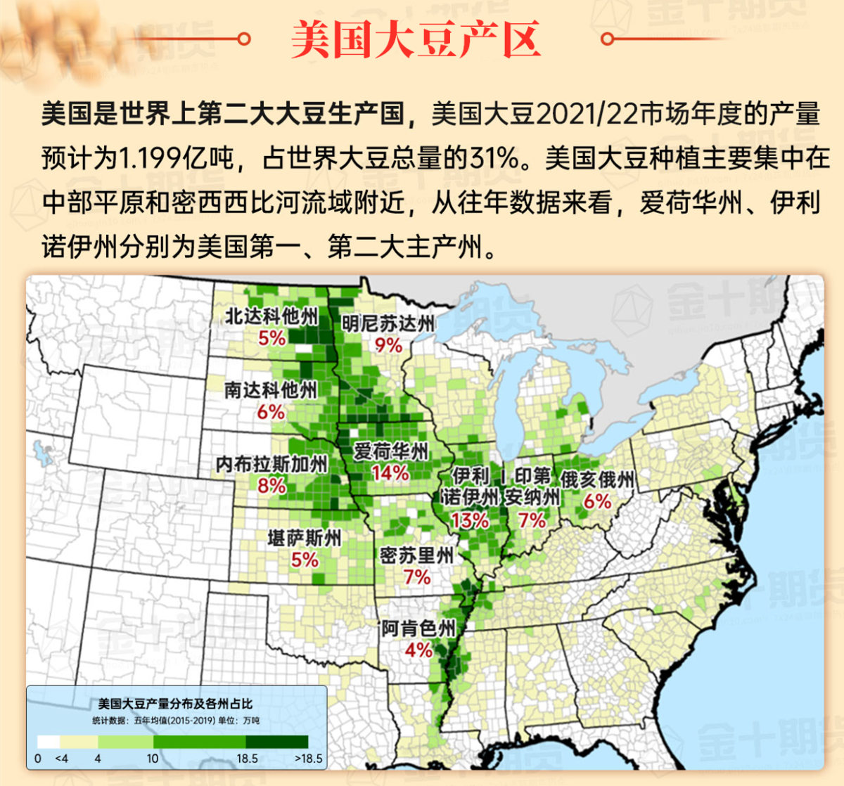
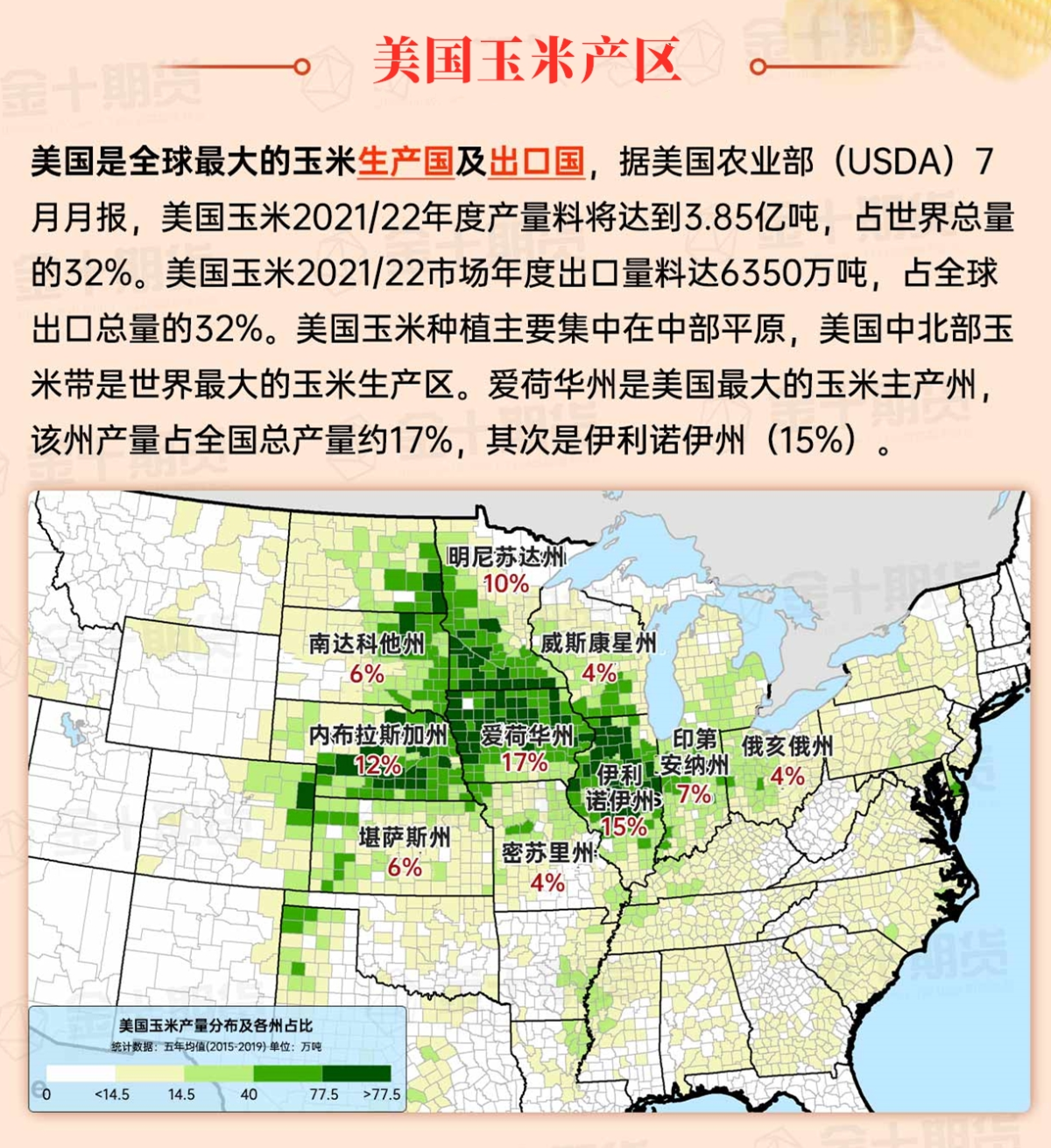
Corn Planting Area of the United States Showers and a few thunderstorms extend southwest from the Upper Midwest. At the same time, warm and mostly dry weather in the eastern corn belt is favorable for late-season corn and soybean planting, as well as winter wheat growth.
 In the plains, cold and dry weather prevails. Following a winter storm over the weekend, while the northern and central plains are generally covered in snow, the blowing snow is most severe in central and eastern Kansas. The new snowfall helps provide insulation for the winter Wheat, and earlier today, temperatures in areas like southern Kansas have dropped below 0°F. In the most severely affected areas of the central plains, traffic access for ranching remains very difficult.
Weather Outlook Initially, the active weather in most parts of the United States will eventually consolidate along the cold front sweeping through the central United States on Tuesday. Subsequently, the cold front will reach the coastal states along the Atlantic Ocean on Thursday, although cool and unstable showers will persist in the Great Lakes states for a few days. According to preliminary reports, the United States will breathe a sigh of relief from the continuous thunderstorms that triggered more than 500 tornadoes in May. Before calm weather arrives, precipitation in the eastern half of the United States may reach 1 to 3 inches, except in the southern hinterland. In addition, early heat waves will expand in the western United States this weekend, with maximum temperatures exceeding 110 degrees Fahrenheit and covering lower altitude areas in the desert southwest.
Wind and snow continue in the Ohio River Valley and downwind of the Great Lakes. The entire Midwest remains cold, with morning low temperatures ranging from below 0°F in the upper Midwest to around 25°F near the Ohio River. In the southern Corn Belt, transportation is still difficult due to snow and ice cover; earlier today, power outages caused by the blizzard have affected over 0.1 million residents in Missouri, Illinois, and Indiana.
Map of US Corn Production Areas
Earlier today, the cold weather in the south extended into central southern Texas and southwestern Louisiana. Meanwhile, significant winter precipitation occurred from the Ozark Plateau to the Mid-Atlantic region, with snowfall still affecting Northern Virginia and its surrounding areas. In other areas, a few strong thunderstorms occurred from eastern Texas to Mississippi on Sunday, and the threat of severe convective weather has now shifted to the southeastern lowlands.
Weather Outlook
The storm system currently moving through the central and southern Appalachian Mountains is expected to exit the Mid-Atlantic coast later today. Although flurries will continue in the downwind areas of the Appalachian Mountains and the Great Lakes, the winter precipitation in the Mid-Atlantic region will end tonight. After the storm departs, extremely cold air will enter, and by midweek, nighttime lows of -0°F are expected to persist across the central plains and western Corn Belt. However, the new fallen snow should help provide insulating protection for winter wheat, especially in the central plains. Meanwhile, the threat of low temperatures below 32°F will continue into later this week, affecting areas including central southern Texas and northern Florida, with critical winter Agriculture regions in Texas and the Florida peninsula potentially facing frost and minor freeze damage risks. Later this week, a new storm system may develop in the northern Gulf of Mexico, with precipitation expected again in the southern and eastern regions.
The National Weather Service's 6-10 day weather outlook for the USA from January 11 to 15, 2025: Above-normal temperatures are expected in most parts of the country, with only northern Maine, certain areas in northern and central California, and parts of the north-central USA having warmer-than-normal temperatures. At the same time, precipitation is expected to be near or below normal levels across most of the country, while above-normal precipitation is anticipated along the Atlantic coast, in the plains, and in the central and southern Rocky Mountains.
Soybeans should be translated as soybean.

The Atlantic Ocean should be translated as the Atlantic.

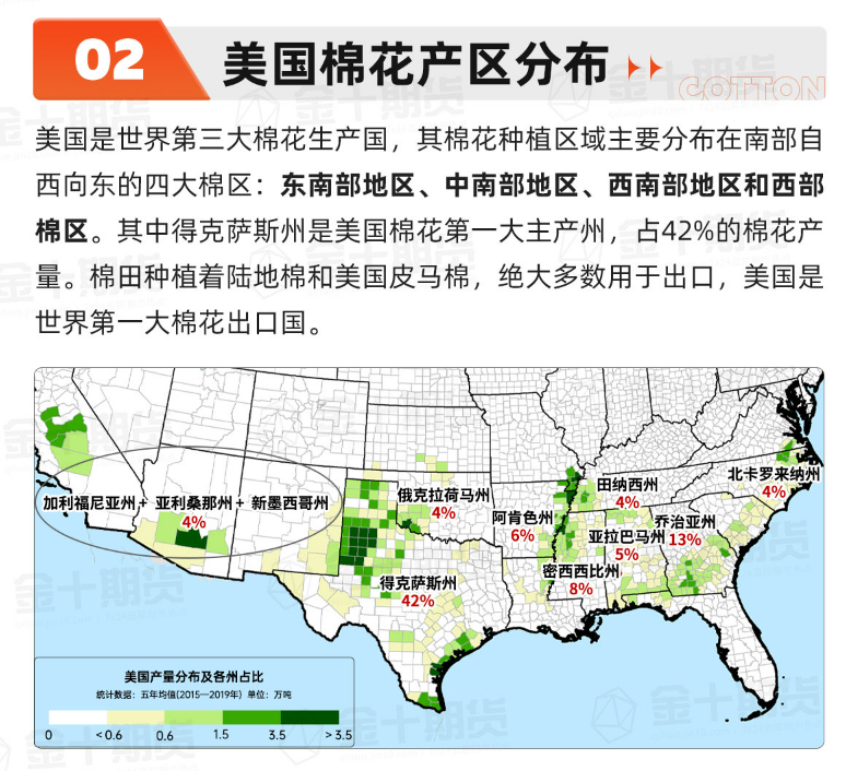
Cotton should be translated as cotton.


 在平原地区,被寒冷、干燥的天气笼罩着。周末冬季风暴过后,尽管整个北部和中部平原地区普遍被积雪覆盖,但堆积的风吹雪在堪萨斯州的中部和东部最为严重,新降的积雪有助于为冬小麦提供隔热保护,今天早些时候,堪萨斯州南部等地区的气温已降至零下0°F以下。对于中部平原受灾最严重的地区,畜牧场的交通通行仍然十分困难。