The US National Weather Service's 6-10 day forecast from January 1, 2025 to January 5, 2025 indicates that the entire plains, western, and northern regions of the United States may experience temperatures close to or above normal.
The following are US agricultural weather tips for Friday December 27, 2024, compiled exclusively by the Jin10 Futures App
Western US region
Pacific storm activity continues, causing unstable and rainy weather. Similar to other recent weather systems, the heaviest precipitation is concentrated in the northwest, and higher-than-normal temperatures limit snow cover, causing it to accumulate only at high altitudes. Regions from Southern California to the southern Rockies remain warm and dry, and mountain snow cover is either nonexistent or significantly below average.
American Plains
 Heavy fog disrupted local activity, particularly from east Dakota south to North Texas. Despite widespread fog and cloud cover, higher-than-normal temperatures limited the remaining snow cover to North Dakota, the north-central and eastern regions, and parts of neighboring states.
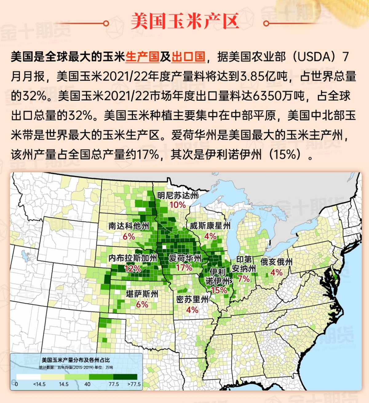
American corn growing belt
The mild and rainy weather has further mitigated the droughts that have developed in recent months. According to the US Drought Monitor, 40% of the Midwest region experienced a drought on December 24, below the peak of nearly 75% in late October. Warmer than normal weather is common in the Midwest, and today's high temperatures are expected to vary from close to 35°F (about 1.7°C) in and around northern Minnesota to 60°F (about 15.6°C) or higher in the Ohio Valley.
Southern region of the United States
Thunderstorm activity abated, and the previous day's severe weather outbreak triggered several tornadoes in Louisiana and East Texas. However, a series of showers stretching from the Tennessee Valley to the Central Gulf coast continued to advance eastward. The southern Atlantic states also experienced sporadic showers. The southeast summer crop harvest is nearing its end, and as of December 22, the cotton harvest in Florida was 96% complete.
Weather outlook
After intense thunderstorms last night in the western and central Gulf Coast states, the southern region will once again experience severe weather this weekend. Heavy rain will also arrive, with a total of 2 to 4 inches or more of rain over 5 days from the Mississippi Delta to the central and southern Appalachians. Any winter precipitation in the eastern US will be limited to parts of the Northeast. However, at the beginning of next week, cooler air will begin to penetrate the plains and the Midwest, although temperatures will not fall below the abnormally low levels this time of year. Meanwhile, cooler air will also cover the western region, coinciding with the arrival of dry weather in Northern California and the Northwest. As the last Pacific system in the current series of storms rapidly moves eastward, a snowfall zone may occur from the North Plains to the Midwest in the last few days of the year.
The US National Weather Service's 6-10 day forecast for January 1, 2025 to January 5, 2025 shows that the entire plains, western, and northern regions are likely to experience temperatures close to or above normal, while the corn belt area from central and east to the east of the Central Gulf Coast states will cover temperatures lower than normal. Meanwhile, southern Texas and northern regions are expected to experience near or above normal precipitation, in contrast to dry weather in other parts of the country, including the southern two-thirds of the United States.
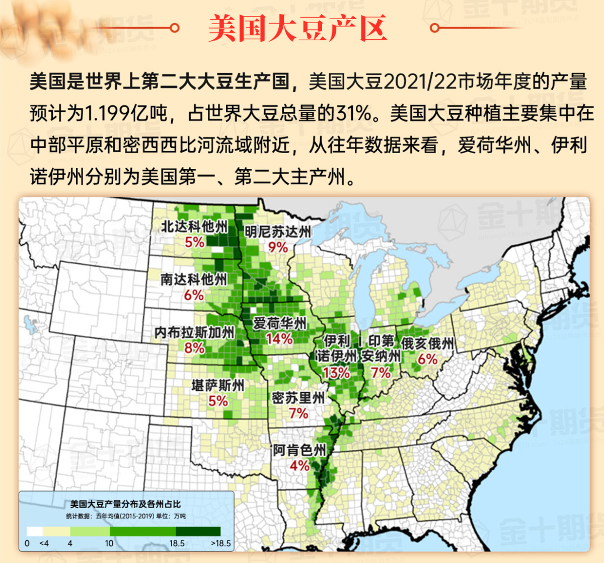
Map of soybean growing regions in the United States

Map of corn growing regions in the United States

Map of cotton growing regions in the United States


 浓雾导致当地活动中断,尤其是从东达科他州向南至北德克萨斯州。尽管大范围的雾和云层覆盖,但高于正常水平的气温使得剩余的积雪仅限于北达科他州、中北部和东部,以及邻近州的部分地区。