The forecast from the National Weather Service of the USA from December 17 to 21 indicates that the weather will be warmer than usual in almost the entire country.
The following is the Agriculture weather advisory for the USA on Thursday, December 12, 2024, exclusively compiled by the Jinshi Futures APP.
Western United States Cool and rainy weather extends from the northwestern Pacific to the northern Rockies. This rain is beneficial for crops in the northwest, including winter wheat and small grains sown in the spring. At the same time, the hot weather in the Southwest is beneficial for farming and crop growth, although there is a high wildfire threat in some areas of Arizona and New Mexico.
In the western region, precipitation, including snowfall in high-altitude areas, is spreading inland towards northern California, central California, and the Pacific Northwest. Meanwhile, in Southern California, weakening winds and increasing humidity have reduced the threat of wildfires and helped control existing fires. The Franklin Fire near Malibu, California has burned over 4,000 acres of vegetation and damaged or destroyed at least 15 structures, with assessment work still ongoing.
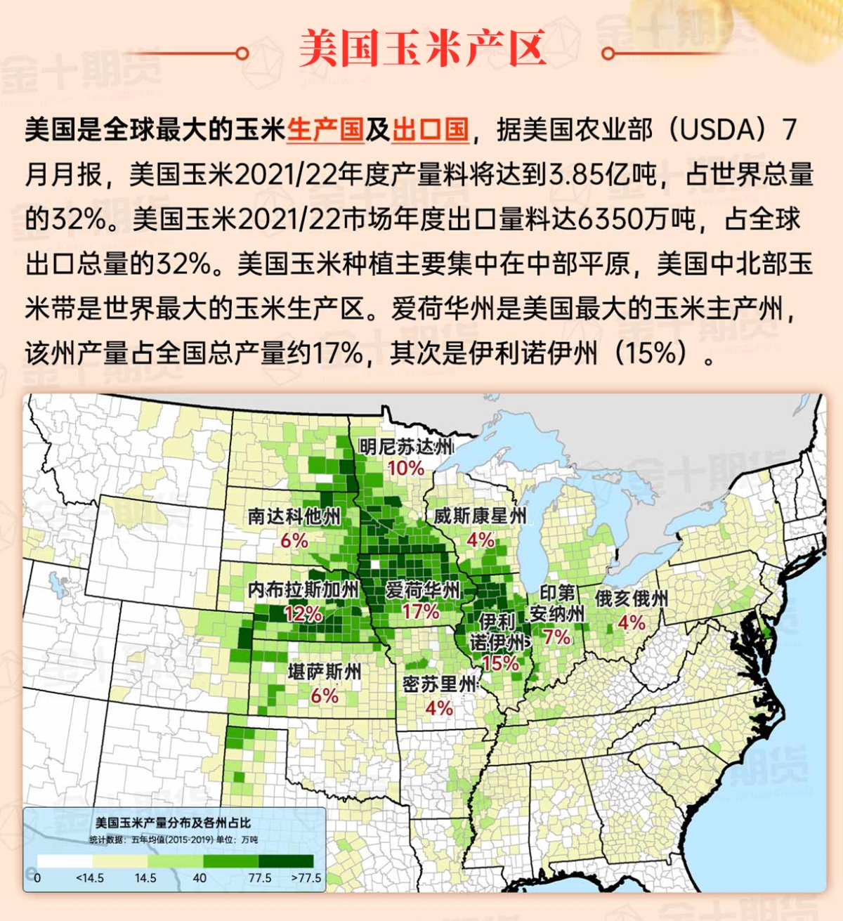
Corn Planting Area of the United States Showers and a few thunderstorms extend southwest from the Upper Midwest. At the same time, warm and mostly dry weather in the eastern corn belt is favorable for late-season corn and soybean planting, as well as winter wheat growth.
 In the Great Plains region, dry weather is dominant. However, the severe cold weather in eastern Montana and Dakota contrasts with the mild conditions in the high plains and southern plains. In parts of North Dakota, high temperatures will remain below 0°F for the second consecutive day, while temperatures in central Montana may approach 50°F. Any snow cover is scattered and generally limited to eastern Montana and Dakota.
Weather Outlook Initially, the active weather in most parts of the United States will eventually consolidate along the cold front sweeping through the central United States on Tuesday. Subsequently, the cold front will reach the coastal states along the Atlantic Ocean on Thursday, although cool and unstable showers will persist in the Great Lakes states for a few days. According to preliminary reports, the United States will breathe a sigh of relief from the continuous thunderstorms that triggered more than 500 tornadoes in May. Before calm weather arrives, precipitation in the eastern half of the United States may reach 1 to 3 inches, except in the southern hinterland. In addition, early heat waves will expand in the western United States this weekend, with maximum temperatures exceeding 110 degrees Fahrenheit and covering lower altitude areas in the desert southwest.
In the Corn Belt region, cold and windy conditions are limiting outdoor activities. Additionally, light snow is falling in parts of the western Corn Belt, while snowstorms are raging downwind of the Great Lakes, especially in Michigan. Today, low temperatures in parts of the upper Midwest are dropping below -10°F, primarily from North Dakota down to northern Wisconsin.
Map of US Corn Production Areas
In the southern region, following recent rainfall, cold and dry weather has set in. This morning, light frost was observed in the area north of the citrus belt in northern Florida. This week's rainfall in the southeast has improved soil moisture in previously dry areas, positively impacting pastures, winter wheat, and cover crops. However, the rainfall has also slowed late-season fieldwork, including Cotton harvesting, which has reached 93% completion in Florida as of December 8.
Weather Outlook
Cold conditions in the Midwest and East will alleviate over the weekend, with temperatures returning to above normal levels early next week. Snowstorms downwind of the Great Lakes will diminish tonight as a high-pressure system moves in. Over the weekend and early next week, several fast-moving disturbances will traverse the country, bringing light precipitation. The first system will produce some rain and snow in the Midwest during the weekend, while bringing light rain to the southern regions. A second system early next week will have similar effects, resulting in total precipitation over the next 5 days of 1 to 2 inches from northeastern Texas to the Ohio Valley. Over the next 5 days, much of the Plains, Southwest, and Southeast will remain dry, while a series of Pacific storm systems will maintain unstable, stormy conditions in northern California and from the Pacific Northwest to the Northern Rockies.
The USA National Weather Service's outlook for December 17 to 21 shows that weather will be warmer than normal across nearly the entire country, with northern high plains and adjacent Rocky Mountain regions most likely to experience above-normal temperatures. Meanwhile, near or below normal precipitation across much of the country will contrast with moist conditions in the Pacific Northwest, central and southern Texas, and parts of the Atlantic coastal states.
Soybeans should be translated as soybean.

The Atlantic Ocean should be translated as the Atlantic.

Cotton should be translated as cotton.


 在大平原地区,干燥天气占主导地位。然而,蒙大拿州东部和达科他州的严寒天气与高平原和南部平原的温和条件形成对比。北达科他州部分地区连续第二天的高温将保持在0°F以下,而中部蒙大拿州的气温可能接近50°F。任何积雪覆盖都是零星的,通常局限于蒙大拿州东部和达科他州。