The National Weather Service's outlook for the 6 to 10 days from December 14 to 18 shows that, except for southern Florida where temperatures will be near normal, most parts of the country will experience above-normal temperatures.
The following is a weather advisory for agriculture in the usa on Monday, December 9, 2024, exclusively compiled by the Jinshi Futures APP.
Western United States Cool and rainy weather extends from the northwestern Pacific to the northern Rockies. This rain is beneficial for crops in the northwest, including winter wheat and small grains sown in the spring. At the same time, the hot weather in the Southwest is beneficial for farming and crop growth, although there is a high wildfire threat in some areas of Arizona and New Mexico.
In the western region, continued warm weather from southern California to southern New Mexico is beneficial for cotton harvesting and other late-season fieldwork. Other areas of the western usa are covered by cold air, with dense fog and stagnant air occurring this morning in California's San Joaquin Valley and the northwest inland areas.
Corn Planting Area of the United States Showers and a few thunderstorms extend southwest from the Upper Midwest. At the same time, warm and mostly dry weather in the eastern corn belt is favorable for late-season corn and soybean planting, as well as winter wheat growth.
 In the Great Plains region, generally mild and dry weather prevails except for scattered snow in Montana and the Dakotas. Aside from areas along the usa-canada border, winter wheat has yet to form a protective snow cover. However, last week's cold wave did not bring temperatures low enough to severely threaten wheat crops. Today's high temperatures are expected to range from nearly 25°F (about -3.89°C) in parts of North Dakota to 70°F (about 21.11°C) or higher in central Texas, with warm weather in the southern plains leading to some additional growth before dormancy.
Weather Outlook Initially, the active weather in most parts of the United States will eventually consolidate along the cold front sweeping through the central United States on Tuesday. Subsequently, the cold front will reach the coastal states along the Atlantic Ocean on Thursday, although cool and unstable showers will persist in the Great Lakes states for a few days. According to preliminary reports, the United States will breathe a sigh of relief from the continuous thunderstorms that triggered more than 500 tornadoes in May. Before calm weather arrives, precipitation in the eastern half of the United States may reach 1 to 3 inches, except in the southern hinterland. In addition, early heat waves will expand in the western United States this weekend, with maximum temperatures exceeding 110 degrees Fahrenheit and covering lower altitude areas in the desert southwest.
In the corn belt region, mild weather has temporarily replaced last week's cold and windy conditions. Later today, most areas of the southern corn belt will see high temperatures exceed 55°F (about 12.78°C), while temperatures across all Midwest regions will rise above 32°F (about 0°C), except for the North Red River Valley. Overnight rainfall has affected the southern and eastern corn belt, with scattered showers still occurring this morning in the Ohio River Valley and lower Great Lakes region.
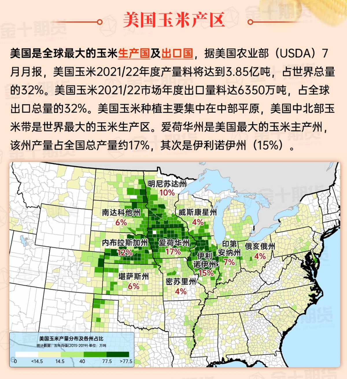
Map of US Corn Production Areas
In the southern region, warm weather prevails, especially along the western Gulf of Mexico. Today, most areas of coastal and southern Texas will see high temperatures exceeding 80°F (approximately 26.67°C). Meanwhile, rainfall is occurring this morning in the southeastern region, except for the Florida Peninsula. In the drought-affected southeastern areas, the rain is beneficial for pastures, winter wheat, and cover crops.
Chicago SRW Wheat and Corn Futures
A complex storm system is developing in the eastern usa, bringing active weather in the first half of this week. From southeastern Louisiana to the western Florida Gulf Coast, and extending northeast into the mid-atlantic states and New England, early to mid torrential rainfall totals could reach 2 to 4 inches. However, the Florida Peninsula will miss out on significant rainfall. Following the rain, a sharp cold wave will occur, with blizzards expected in the Great Lakes downwind region late in the week. Similar to last week, temperatures in northern Florida may drop to 32°F (approximately 0°C) or below. On Thursday morning, temperatures in the North Red River Valley will range from -10 to -20°F (approximately -23.33 to -28.89°C), with readings below 0°F (approximately -17.78°C) possibly extending into southern Iowa. Elsewhere, widespread dry weather patterns in the western and central usa may start to break down late in the week, with a few rounds of light precipitation possible in the western region, and rain and snow may occur in the midwest on Friday.
The National Weather Service's 6 to 10 day outlook from December 14 to 18 shows that, except for southern Florida where temperatures are near normal, most of the country will experience temperatures above normal. The south-central usa is most likely to see above-normal temperatures. Meanwhile, except for southern California and the southwestern to central plateau regions, most of the country will have precipitation close to or above normal levels.
Soybeans should be translated as soybean.

The Atlantic Ocean should be translated as the Atlantic.

Cotton should be translated as cotton.


 在大平原地区,除了蒙大拿州和达科他州的零星降雪外,普遍呈现温和干燥的天气。除了美国-加拿大边境沿线地区外,冬小麦尚未形成保护性积雪覆盖。然而,上周的寒潮并未导致气温降至足以严重威胁小麦作物的水平。今日最高气温预计将从北达科他州部分地区的近25°F(约-3.89°C)到德克萨斯州中部的70°F(约21.11°C)或更高,南部平原的温暖天气将在休眠前导致一些额外的生长。