The 6-10 day outlook from December 11th to 15th by the USA National Weather Service shows that temperatures in most parts of the country may be close to or above normal levels.
The following is the agriculture weather advisory for the usa on Friday, December 6, 2024, exclusively compiled by the Golden Ten Futures APP.
Western United States Cool and rainy weather extends from the northwestern Pacific to the northern Rockies. This rain is beneficial for crops in the northwest, including winter wheat and small grains sown in the spring. At the same time, the hot weather in the Southwest is beneficial for farming and crop growth, although there is a high wildfire threat in some areas of Arizona and New Mexico.
In the western region, mild and dry weather prevails ahead of an incoming pacific storm system. However, due to a high-pressure system still hovering over the northern and northwestern Great Basin, some valley areas continue to experience air stagnation and freezing fog, leading to reduced visibility. Meanwhile, in the desert southwest, temperatures will once again approach or reach 80°F (about 26.7°C) later today, favorable for late-season fieldwork.
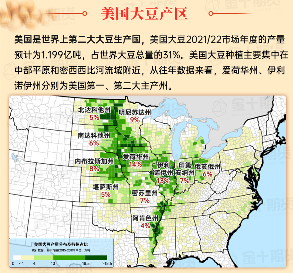
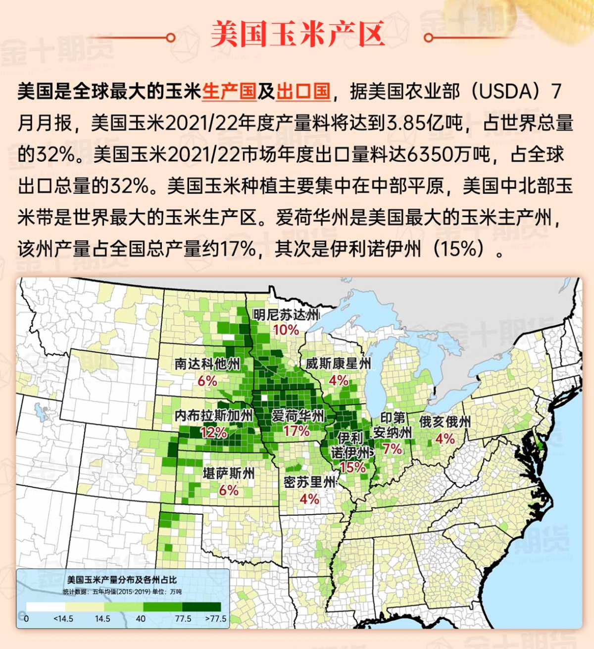
Corn Planting Area of the United States Showers and a few thunderstorms extend southwest from the Upper Midwest. At the same time, warm and mostly dry weather in the eastern corn belt is favorable for late-season corn and soybean planting, as well as winter wheat growth.
 In the Great Plains region, a dry weather pattern has established. However, temperatures in the plateau areas are above normal, contrasting with the continued cool conditions in the eastern region. High temperatures today in the northern Red River Valley will remain below 32°F (about 0°C), but parts of the central plateau should reach 60°F (about 15.6°C) or higher. Some areas in Montana are preparing for strong westerly winds expected to begin later today.
Weather Outlook Initially, the active weather in most parts of the United States will eventually consolidate along the cold front sweeping through the central United States on Tuesday. Subsequently, the cold front will reach the coastal states along the Atlantic Ocean on Thursday, although cool and unstable showers will persist in the Great Lakes states for a few days. According to preliminary reports, the United States will breathe a sigh of relief from the continuous thunderstorms that triggered more than 500 tornadoes in May. Before calm weather arrives, precipitation in the eastern half of the United States may reach 1 to 3 inches, except in the southern hinterland. In addition, early heat waves will expand in the western United States this weekend, with maximum temperatures exceeding 110 degrees Fahrenheit and covering lower altitude areas in the desert southwest.
In the corn belt region, there are still snow showers in the downstream areas of the Great Lakes. In other parts of the Midwest, cold, dry, and windy weather prevails. High temperatures in the northern and eastern corn belt will mainly remain below 32°F, but cold air intrusion is beginning to occur in the southwestern corn belt in most parts of Nebraska.
Map of US Corn Production Areas
In the southern region, the cold but dry weather is favorable for late field operations, including final harvesting efforts. In Florida, as of December 1, 82% of the cotton planting area has been harvested. As the growing season comes to an end, producers are shifting their focus to off-season activities, including farm maintenance, except for the winter agriculture areas in Texas and Florida.
Chicago SRW Wheat and Corn Futures
In the next five days, a storm system will traverse the northern usa, starting in the pacific northwest on Saturday and reaching Lake Superior by Monday evening. Low-pressure waves along the cold front trailing the storm will enhance precipitation across much of the eastern usa from early to mid-next week. Rainfall totals in the next five days should reach 2 to 4 inches or more from the central Gulf Coast to the southern Appalachian region. Initial snowfall from the system will be limited to the north, although parts of the midwest and northwest will experience accumulations as colder air is drawn into the system. Elsewhere, from California to the central plains and western corn belt, much of the weather will remain dry over the next five days.
The usa National Weather Service's 6 to 10 day outlook from December 11 to 15 indicates that temperatures across much of the country may be near or above normal, while parts of the southeast may be below normal. Meanwhile, precipitation is near or below normal over much of the country, contrasting with wetter-than-normal conditions in parts of the northwest, along the atlantic coast, and in Texas.
Soybeans should be translated as soybean.

The Atlantic Ocean should be translated as the Atlantic.

Cotton should be translated as cotton.


 在大平原地区,干燥的天气模式已经建立。然而,高原地区气温高于正常,与东部地区持续的凉爽条件形成对比。今天在北红河谷的高温将保持在32°F(约0°C)以下,但中部高原部分地区的气温应达到60°F(约15.6°C)或更高。蒙大拿州部分地区正准备迎接今天晚些时候开始的强西风。