The National Weather Service of the usa predicts from December 7 to 11 that temperatures may be above normal levels from the pacific coast to the plains, while most areas east of the Mississippi River will generally experience colder conditions below normal levels.
The following is the usa agricultural weather advisory for Monday, December 2, 2024, exclusively compiled by the Jinshi Futures APP.
Western United States Cool and rainy weather extends from the northwestern Pacific to the northern Rockies. This rain is beneficial for crops in the northwest, including winter wheat and small grains sown in the spring. At the same time, the hot weather in the Southwest is beneficial for farming and crop growth, although there is a high wildfire threat in some areas of Arizona and New Mexico.
In the western region, dry weather accompanies temperatures near or above normal. Clear weather benefits off-season activities, including farm maintenance and any remaining field work. As of November 24, cotton harvesting in California is 95% complete, and in Arizona, it is 78% complete.
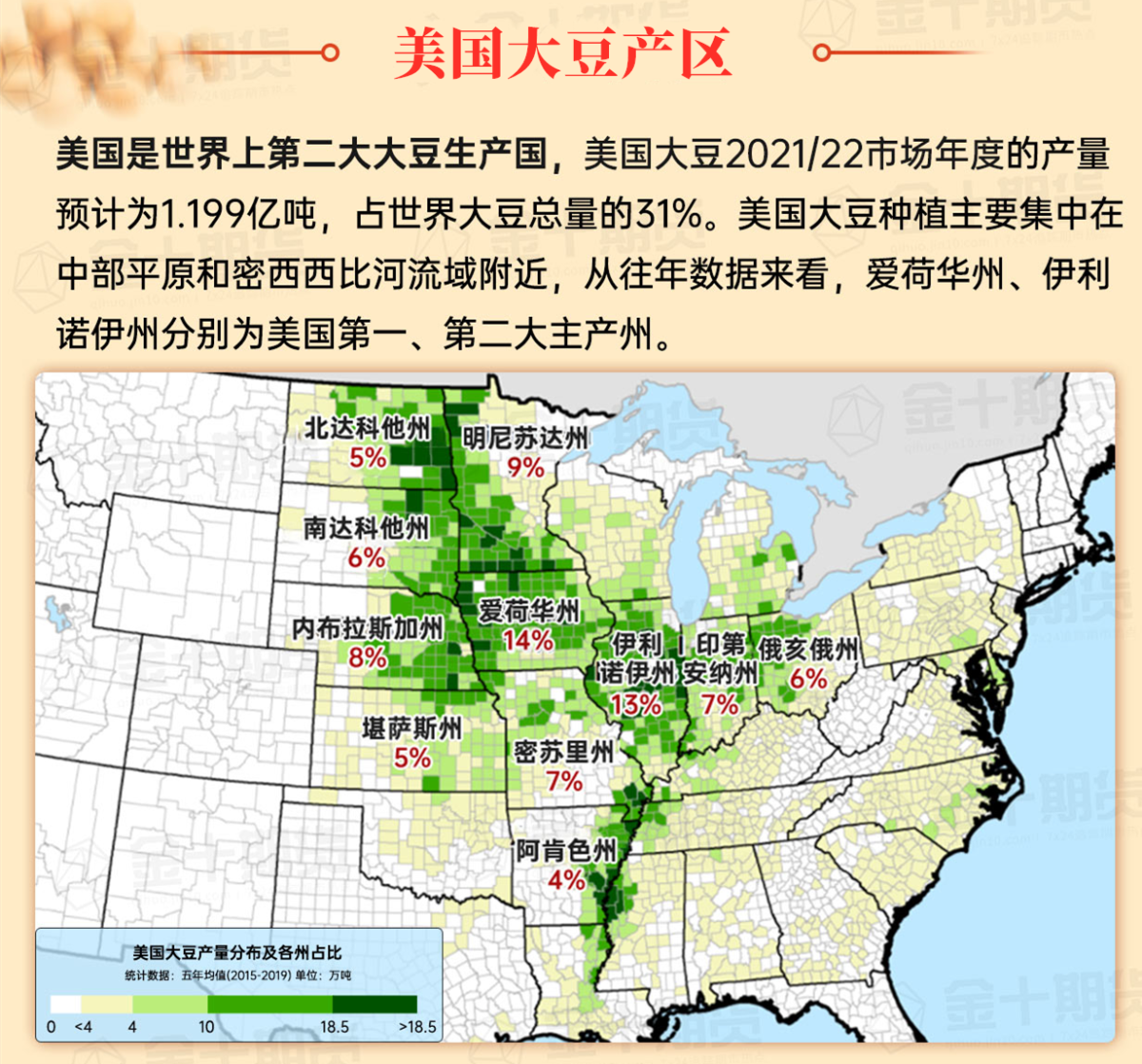
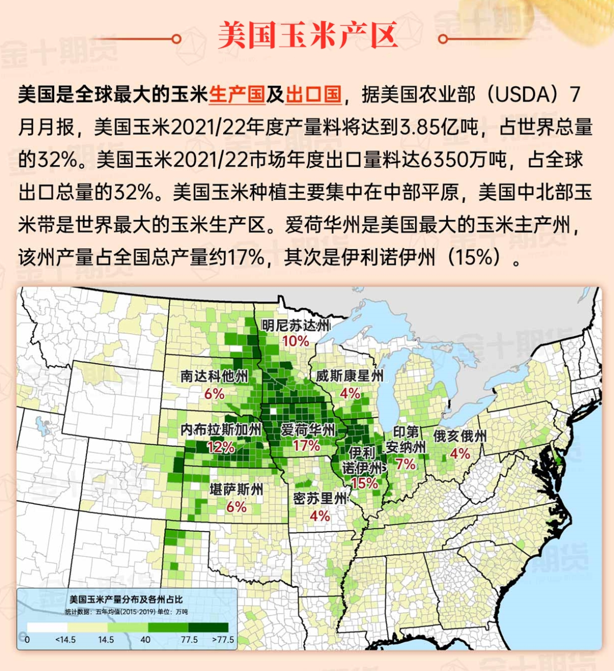
Corn Planting Area of the United States Showers and a few thunderstorms extend southwest from the Upper Midwest. At the same time, warm and mostly dry weather in the eastern corn belt is favorable for late-season corn and soybean planting, as well as winter wheat growth.
 In the Great Plains region, unusually cold conditions persist in Montana and the Dakotas, with uneven snow cover, ongoing drought, and increased winds adding stress to livestock. The cold weather is also suppressing the growth of winter wheat, especially in the northern part of the plains. Most areas are dry, except for sporadic snowflakes in the northern plains.
Weather Outlook Initially, the active weather in most parts of the United States will eventually consolidate along the cold front sweeping through the central United States on Tuesday. Subsequently, the cold front will reach the coastal states along the Atlantic Ocean on Thursday, although cool and unstable showers will persist in the Great Lakes states for a few days. According to preliminary reports, the United States will breathe a sigh of relief from the continuous thunderstorms that triggered more than 500 tornadoes in May. Before calm weather arrives, precipitation in the eastern half of the United States may reach 1 to 3 inches, except in the southern hinterland. In addition, early heat waves will expand in the western United States this weekend, with maximum temperatures exceeding 110 degrees Fahrenheit and covering lower altitude areas in the desert southwest.
In the corn belt region, the coldest air of the season still lingers, with today's highs in the Midwest expected to be between 15 and 32°F. Additionally, blizzards continue due to snow showers generated by disturbances crossing the Upper Mississippi Valley and snowstorms downstream of the Great Lakes. Particularly in areas with snow on the ground, conditions for livestock become more difficult due to a sudden shift to cold, windy conditions.
Map of US Corn Production Areas
In the southern region, frost has also appeared in northern Florida this morning, with readings below 25°F from the Tennessee Valley to the Middle Atlantic states. Producers are taking advantage of the cool but dry weather to complete any remaining fieldwork, including the harvesting of summer crops and the planting of winter chicago srw wheat.
Chicago SRW Wheat and Corn Futures
Due to the formation of a high-pressure ridge in the western region, the jet stream descends deeply to the east of the Rocky Mountains, making significant precipitation very scarce over the next 5 days. However, snow showers will continue in the Great Lakes region due to lake-effect snowstorms and a rapidly moving storm system mid-week. Rainfall from the cold front trailing the storm could reach 1 to 2 inches from the Midwest along the Gulf Coast to the Mississippi Delta by mid to late week. Aside from precipitation in the Pacific Northwest over the weekend, other areas of the usa will remain dry, contrasting cold weather in the central and eastern regions with mild conditions in the west.
The National Weather Service's 6 to 10-day outlook from December 7 to 11 predicts that temperatures could be above normal across the pacific coast to the plains, while much of the region east of the Mississippi River will generally experience cold conditions below normal. Meanwhile, precipitation will be above normal in much of the northern, southern, and eastern usa, contrasting with near or below normal precipitation in much of the western region, central plains, and upper Mississippi River areas.
Soybeans should be translated as soybean.

The Atlantic Ocean should be translated as the Atlantic.

Cotton should be translated as cotton.


 在大平原地区,在蒙大拿州和达科他州,异常寒冷的条件持续存在,不均匀的积雪覆盖、持续的干旱和阵风增加了牲畜的压力。寒冷的天气也抑制了冬小麦的发展,特别是在平原北部地区。除了北部平原的零星雪花外,大部分地区天气干燥。