The National Weather Service's 6 to 10-day outlook from December 1 to 5 predicts that much of the usa will experience precipitation close to or below normal levels, contrasting with the wetter conditions along the western gulf coast and parts of the northern plains.
Below is the agriculture weather advisory for the usa on Tuesday, November 26, 2024, exclusively translated by the Jinshi Futures APP.
Western United States Cool and rainy weather extends from the northwestern Pacific to the northern Rockies. This rain is beneficial for crops in the northwest, including winter wheat and small grains sown in the spring. At the same time, the hot weather in the Southwest is beneficial for farming and crop growth, although there is a high wildfire threat in some areas of Arizona and New Mexico.
The influx of moisture from the pacific continues to bring widespread precipitation and high winds from California to the central Rocky Mountains, with heavy snowfall in high elevation areas. As of November 24, 95% of cotton harvesting in California had been completed with the arrival of moist weather, exceeding the past five-year average of 89%. Meanwhile, after several beneficial rainfall events, dry air is gradually covering the northwest region.
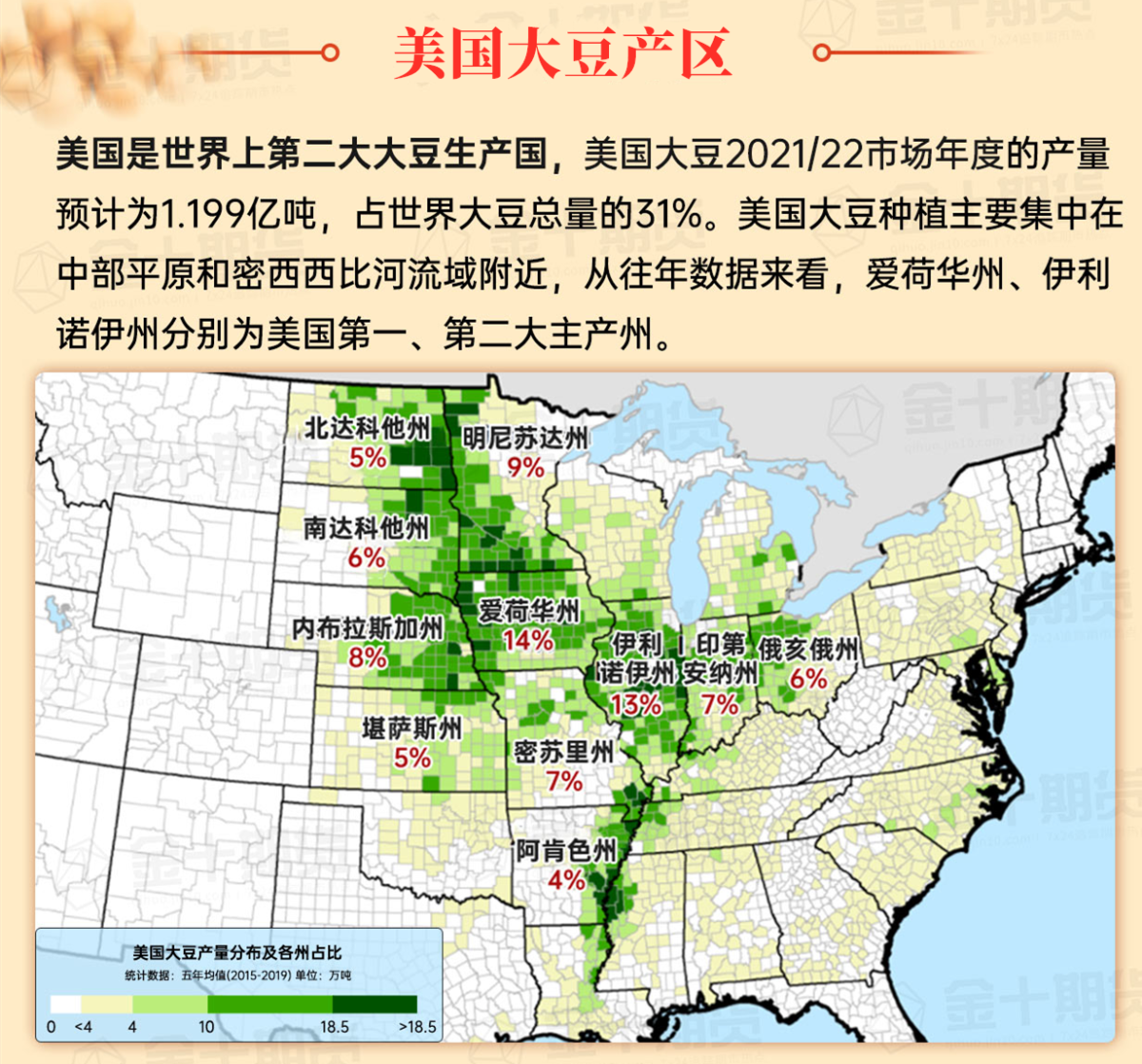
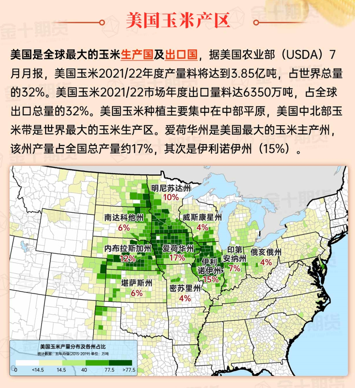
Corn Planting Area of the United States Showers and a few thunderstorms extend southwest from the Upper Midwest. At the same time, warm and mostly dry weather in the eastern corn belt is favorable for late-season corn and soybean planting, as well as winter wheat growth.
 Cold air is entrenched in Montana and the Dakotas, with low temperatures in some areas dipping below 0°F this morning. Variable snow cover along the Canadian border provides some insulation for winter wheat in the northern plains, but drought conditions continue to negatively impact some of the wheat in certain areas. As of November 24, 32% of crops in South Dakota were rated as very poor to poor, while the national average was 12%.
Weather Outlook Initially, the active weather in most parts of the United States will eventually consolidate along the cold front sweeping through the central United States on Tuesday. Subsequently, the cold front will reach the coastal states along the Atlantic Ocean on Thursday, although cool and unstable showers will persist in the Great Lakes states for a few days. According to preliminary reports, the United States will breathe a sigh of relief from the continuous thunderstorms that triggered more than 500 tornadoes in May. Before calm weather arrives, precipitation in the eastern half of the United States may reach 1 to 3 inches, except in the southern hinterland. In addition, early heat waves will expand in the western United States this weekend, with maximum temperatures exceeding 110 degrees Fahrenheit and covering lower altitude areas in the desert southwest.
Cool, dry weather dominates between storm systems. Despite frequent precipitation events in November, producers in the Midwest completed almost all fieldwork before Thanksgiving. For example, in Wisconsin, as of November 24, 97% of corn planting area had been harvested, far exceeding the past five-year average of 82%.
Map of US Corn Production Areas
A weak cold front brings light rain to the states along the atlantic china welding consumables,inc.. Dry weather elsewhere is favorable for late-season fieldwork, including summer crop harvesting and winter chicago srw wheat planting. In Louisiana, as of November 24, 64% of the sugarcane has been harvested, significantly higher than the five-year average of 55%.
Chicago SRW Wheat and Corn Futures
A cold front traversing the eastern usa will leave the atlantic coast later today. Meanwhile, storm activity in the west will move quickly eastward, with precipitation expected to develop in the lower to mid-Mississippi River region late Wednesday. On Thanksgiving Day (November 28), widespread rain is expected in the mid-atlantic and southeastern regions, with rain mixed with snow in the northeast. Following the southeastern precipitation, cold air will move in, with temperatures expected to drop to 32°F or lower by the weekend, possibly as far south as northern Florida. Additionally, over the next few days, early morning readings below 0°F are forecasted for parts of the northern plains and upper midwest. Furthermore, over the next 5 days, most of the central usa, including the great plains and upper midwest, will see little to no precipitation.
The usa National Weather Service's 6-10 day outlook for December 1-5 predicts below normal temperatures in the area east of the Rocky Mountains, while above normal temperatures are expected in the western regions. Meanwhile, most parts of the country are forecasted to have precipitation near or below normal levels, contrasting with the wetter conditions in the western Gulf Coast regions and parts of the northern plains.
Soybeans should be translated as soybean.

The Atlantic Ocean should be translated as the Atlantic.

Cotton should be translated as cotton.


 冷空气在蒙大拿州和达科他州盘踞,今早这些地区的低温局部降至0°F以下。沿加拿大边境的多变积雪覆盖为北部大平原的冬小麦提供了一定保温,但部分地区的干旱仍对一些小麦产生不利影响。11月24日,南达科他州有32%的作物被评为状况极差至差,而全国平均值为12%。