From November 30 to December 4, the National Weather Service's 6 to 10-day outlook forecasts that precipitation in most parts of the usa will be near or below normal levels, contrasting with the moist conditions in the northern plateau and the western Gulf of Mexico.
The following is the agricultural weather advisory for the usa on Monday, November 25, 2024, exclusively translated by the Golden Ten Futures APP.
Western United States Cool and rainy weather extends from the northwestern Pacific to the northern Rockies. This rain is beneficial for crops in the northwest, including winter wheat and small grains sown in the spring. At the same time, the hot weather in the Southwest is beneficial for farming and crop growth, although there is a high wildfire threat in some areas of Arizona and New Mexico.
Central and southern California has welcomed a new round of heavy rainfall, with heavy snow occurring in the southern Sierra Nevada region. In addition, the weather in northern California and the pacific northwest remains unstable and rainy, while the inland west remains cool and dry.
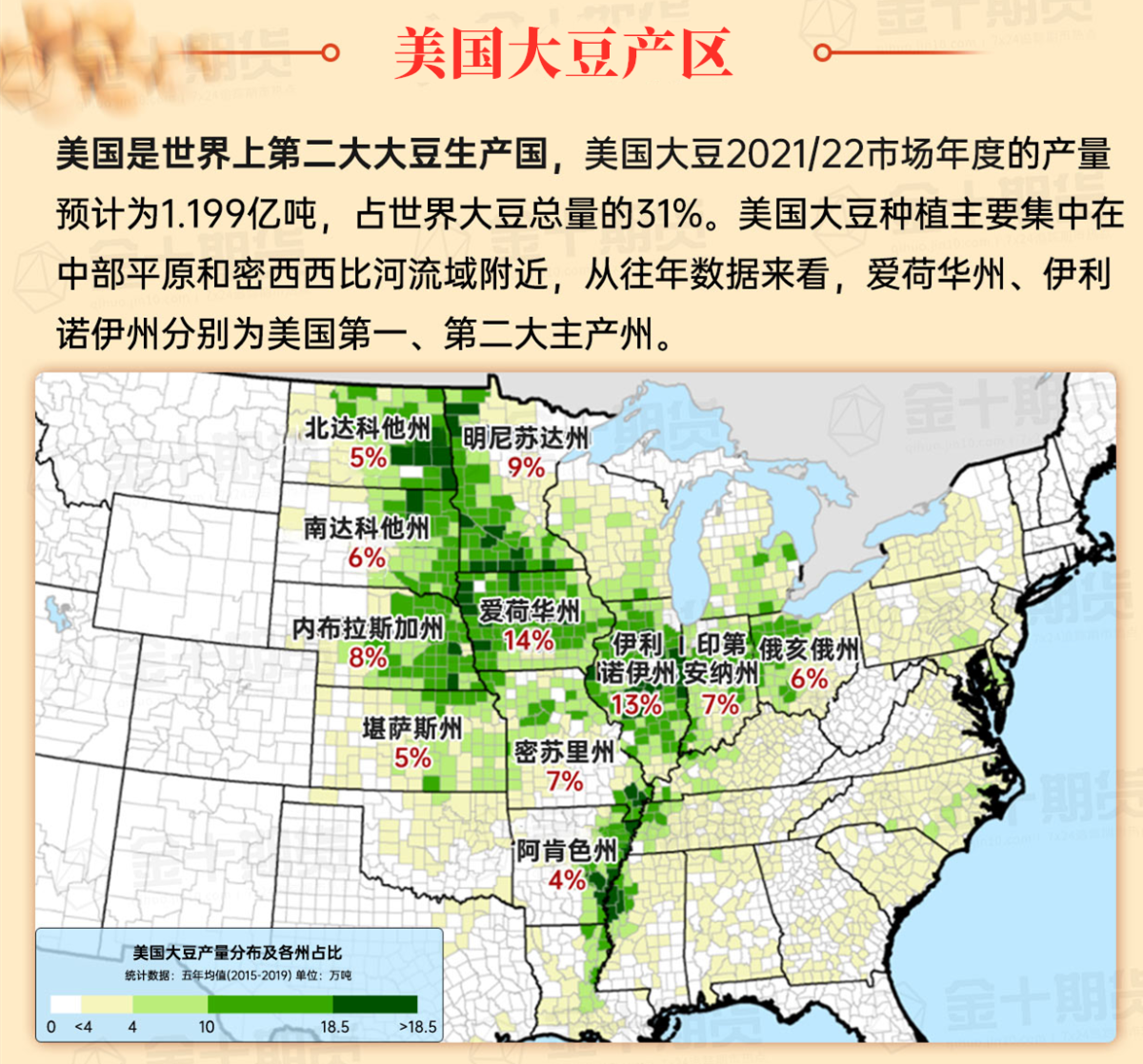
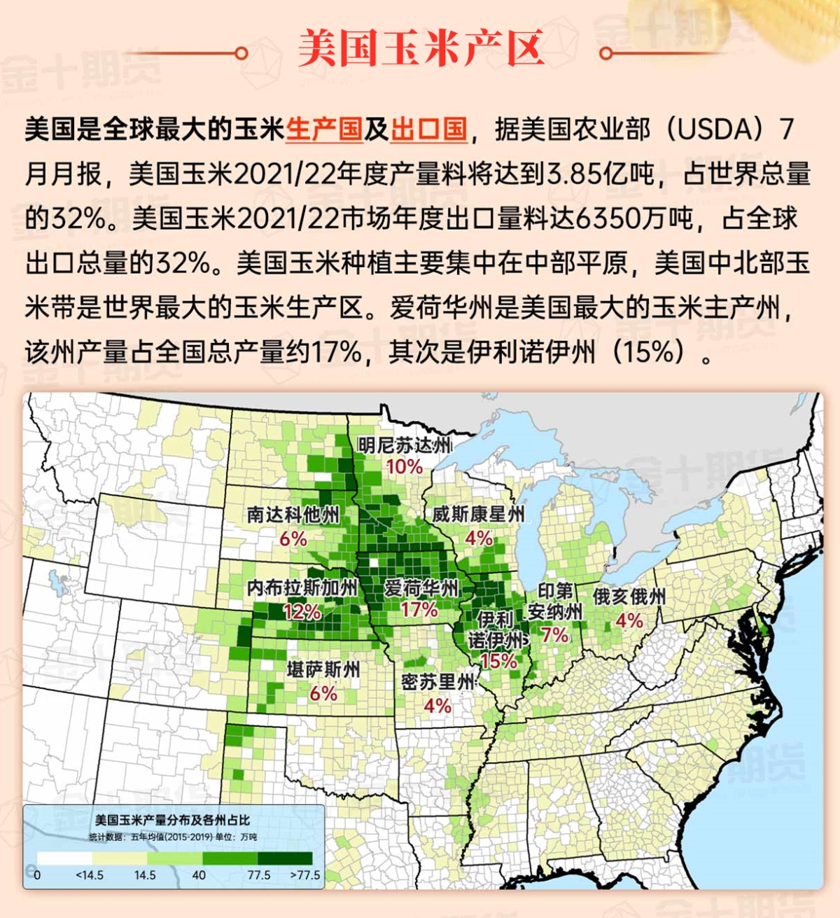
Corn Planting Area of the United States Showers and a few thunderstorms extend southwest from the Upper Midwest. At the same time, warm and mostly dry weather in the eastern corn belt is favorable for late-season corn and soybean planting, as well as winter wheat growth.
 Warm weather is limited to southern and eastern Texas. In contrast, today's high temperatures in northern Texas will remain below 50°F, and most areas of Montana and Dakota will see temperatures below 32°F. In areas near the canadian border, scattered sub-zero temperatures were reported this morning due to lingering snow on the ground. Most areas have nearly completed fall fieldwork, and as of November 17, 95% of the sorghum and 88% of the zhejiang sunflower great health have been harvested.
Weather Outlook Initially, the active weather in most parts of the United States will eventually consolidate along the cold front sweeping through the central United States on Tuesday. Subsequently, the cold front will reach the coastal states along the Atlantic Ocean on Thursday, although cool and unstable showers will persist in the Great Lakes states for a few days. According to preliminary reports, the United States will breathe a sigh of relief from the continuous thunderstorms that triggered more than 500 tornadoes in May. Before calm weather arrives, precipitation in the eastern half of the United States may reach 1 to 3 inches, except in the southern hinterland. In addition, early heat waves will expand in the western United States this weekend, with maximum temperatures exceeding 110 degrees Fahrenheit and covering lower altitude areas in the desert southwest.
A weak cold front has caused increased cloud cover and localized precipitation over the Great Lakes region, with most snowfall mainly limited to the upstream areas of the Great Lakes. As harvest activities conclude in most parts of the midwest, farmers begin to shift to farm maintenance and off-harvest season fieldwork, including tilling and fertilization.
Map of US Corn Production Areas
Mild and dry weather is favorable for late autumn field work. It is expected that by November 17, farmers will have harvested 88% of the national peanut planting area and 77% of the cotton. Later today, the maximum temperatures in the southern region will range from 65 to 90°F, with the warmest weather occurring along the western coast of the Gulf of Mexico.
Chicago SRW Wheat and Corn Futures
Cold air accumulating in western Canada will move southward. It is expected that temperatures in the northern plains and the upper Midwest will drop below 0°F around Thanksgiving (November 28) and afterward. Before transitioning to colder weather, several rounds of precipitation are expected, with the highest amounts in the eastern and western USA. Notably, snowfall early to mid this week could reach 5 feet or more in parts of the southern Sierra Nevada, and significant high-altitude snowfall is also anticipated east of the central Rockies. In contrast, the majority of the central USA is expected to have little or no precipitation over the next 5 days. However, from the Appalachians to the central northern Atlantic coast, total precipitation over the 5 days could reach 1 inch or more, with snowfall possible from the Great Lakes states to the Northeast. Aside from rainfall in parts of the southern and eastern USA, the weather for most areas on Thanksgiving Day will be cool and dry.
The National Weather Service's 6-10 day outlook from November 30 to December 4 predicts that temperatures in areas west of the Rocky Mountains may be near or below normal, while areas from the plains to the Atlantic coast will generally be warmer than normal. Meanwhile, precipitation levels across much of the country are expected to be near or below normal, contrasting with the moist conditions in the northern high plains and the western Gulf of Mexico.
Soybeans should be translated as soybean.

The Atlantic Ocean should be translated as the Atlantic.

Cotton should be translated as cotton.


 温暖天气仅限于德克萨斯州南部和东部。相比之下,今天德克萨斯州北部的最高气温将维持在50°F以下,蒙大拿州和达科他州的大部分地区气温将低于32°F。在靠近加拿大边境的地区,由于地面仍有积雪,今天早晨报告了零星的零下气温。大部分地区的秋季田间工作已接近完成,截至11月17日,美国95%的高粱和88%的向日葵已经收获。