The 6-10 day outlook forecast from the usa National Weather Service for November 26-30 indicates that temperatures in most regions of the usa may be near or below normal levels.
Here is the agricultural weather forecast for Thursday, November 21, 2024, in the USA, exclusively compiled by GoldenTen Futures App.
Western United States Cool and rainy weather extends from the northwestern Pacific to the northern Rockies. This rain is beneficial for crops in the northwest, including winter wheat and small grains sown in the spring. At the same time, the hot weather in the Southwest is beneficial for farming and crop growth, although there is a high wildfire threat in some areas of Arizona and New Mexico.
A powerful Pacific storm system continues to bring heavy precipitation to northern California, including snowfall in high-altitude areas. Previously, the Pacific Northwest experienced severe weather conditions such as heavy rainfall and strong winds, resulting in over 0.6 million power outages in Washington State. This morning, Washington State still has over 0.3 million users without power.
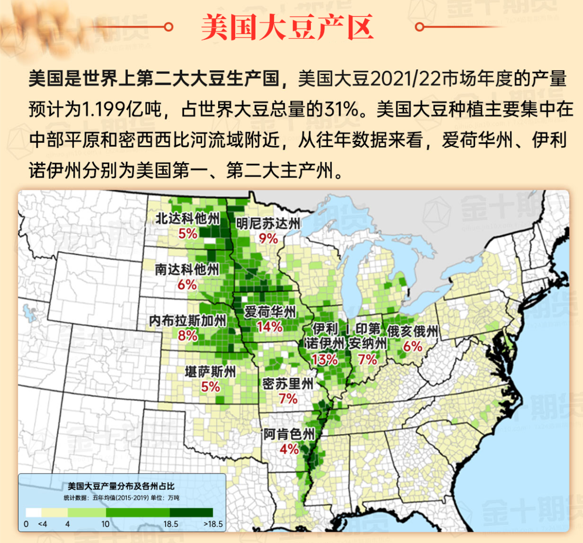
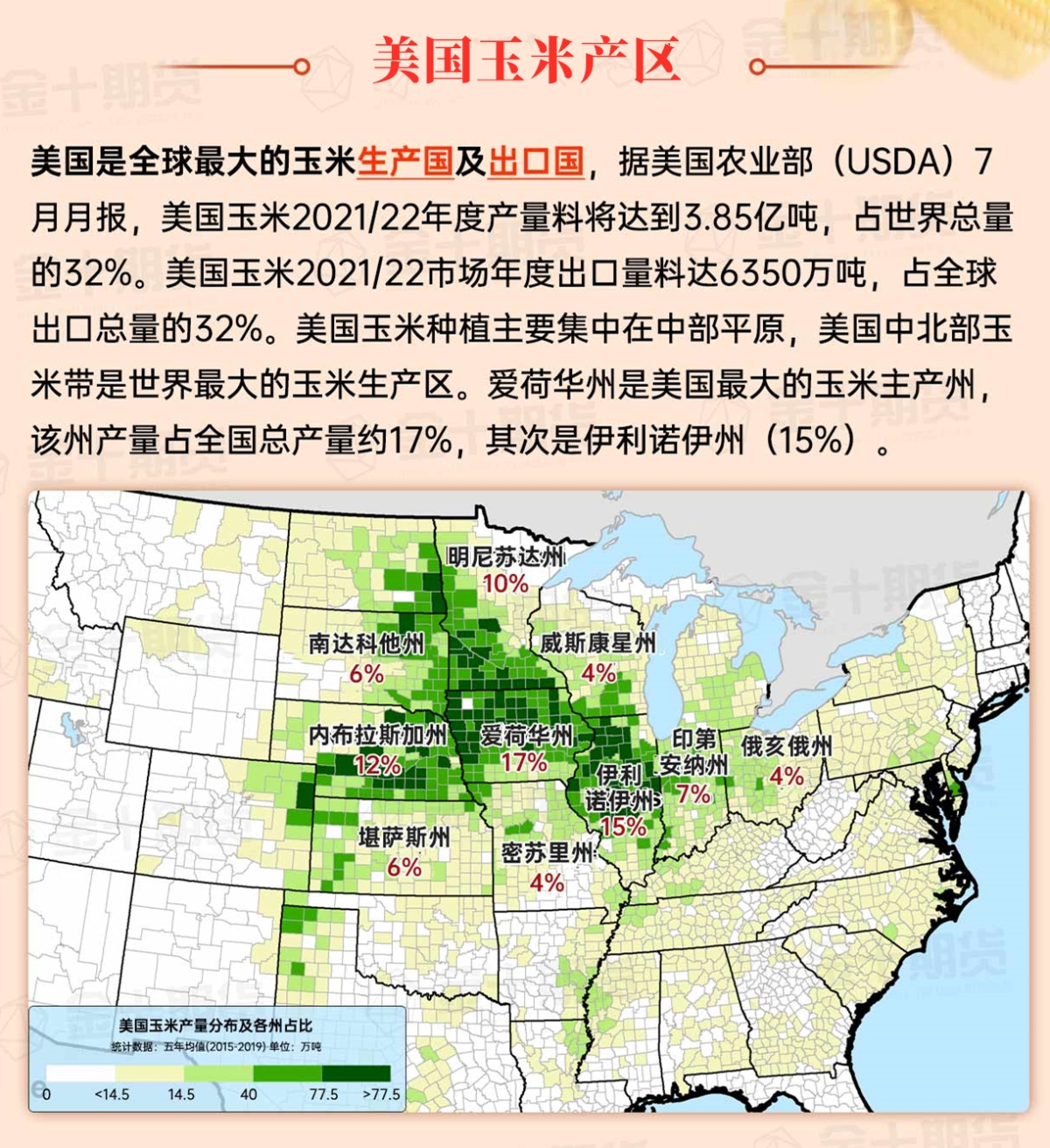
Corn Planting Area of the United States Showers and a few thunderstorms extend southwest from the Upper Midwest. At the same time, warm and mostly dry weather in the eastern corn belt is favorable for late-season corn and soybean planting, as well as winter wheat growth.
 Cold and dry weather prevails. This morning, the minimum temperature in the northern Great Plains region dropped below 10°F, especially in western South Dakota. The cold weather further hinders the winter wheat development in the northern Great Plains region, with the growth of some areas already affected by drought.
Weather Outlook Initially, the active weather in most parts of the United States will eventually consolidate along the cold front sweeping through the central United States on Tuesday. Subsequently, the cold front will reach the coastal states along the Atlantic Ocean on Thursday, although cool and unstable showers will persist in the Great Lakes states for a few days. According to preliminary reports, the United States will breathe a sigh of relief from the continuous thunderstorms that triggered more than 500 tornadoes in May. Before calm weather arrives, precipitation in the eastern half of the United States may reach 1 to 3 inches, except in the southern hinterland. In addition, early heat waves will expand in the western United States this weekend, with maximum temperatures exceeding 110 degrees Fahrenheit and covering lower altitude areas in the desert southwest.
Cool, windy weather accompanied by rain and snow flurries is impeding the final harvesting work, especially from the Great Lakes region to the Ohio River Valley. However, most producers have already completed the harvest of corn and soybeans before this round of adverse weather conditions. Today, the high temperatures in the far upper Midwest will remain below 32°F, including the Northern Red River Valley, but could reach 45°F in the central part of the Mississippi River Valley.
Map of US Corn Production Areas
After the cold front, cool and breezy weather prevails. Given the previous dry conditions, any precipitation in the southern region recently will only cause temporary delays in field work. As long as field conditions allow, producers are planting winter grains and harvesting remaining summer crops such as cotton and peanuts.
Chicago SRW Wheat and Corn Futures
Looking ahead, stormy weather in northern California and the northwest Pacific is expected to continue through the weekend, with rainfall increasing by 10 to 15 inches in the northern Sierra Nevada and coastal areas of northern California. As the western freezing line is expected to rise, heavy rain and snowmelt may lead to localized major flooding in northern California and surrounding areas. Meanwhile, heavy snow is expected to extend into the northern Rockies, although much of the central United States will remain dry over the next five days. Further east, another slow-moving storm system will maintain unstable weather conditions from the Great Lakes region to the Appalachian Mountains and the Northeast region over the next few days. Wind-driven snow showers may cause travel disruptions in parts of the Midwest and East, especially in the Appalachian Mountains, but rainfall in the Northeast will alleviate drought and help extinguish any remaining wildfires.
The 6 to 10-day outlook forecast from the U.S. National Weather Service for November 26-30 predicts that temperatures in most parts of the country may be near or below normal levels, except for the deep southern region, where temperatures may be above normal from southern New Mexico to the southern Atlantic coast. At the same time, precipitation in most parts of the country is expected to be near or above normal levels, contrasting with dry conditions in the northwest Pacific and western parts of Texas.
Soybeans should be translated as soybean.

The Atlantic Ocean should be translated as the Atlantic.

Cotton should be translated as cotton.


 寒冷干燥的天气占主导。今早,北部大平原地区的最低气温降至10°F以下,尤其是在达科他州西部。寒冷的天气进一步限制了北部大平原地区的冬小麦发育,部分地区的冬小麦生长已经受到干旱的影响。