The U.S. National Weather Service's 6-10 day outlook forecast from November 20th to 24th indicates that temperatures across the United States may be near or below normal levels.
The following is the exclusive translation of the agricultural weather forecast for Friday, November 15, 2024 in the USA by Jinshiqi Futures App.
Western United States Cool and rainy weather extends from the northwestern Pacific to the northern Rockies. This rain is beneficial for crops in the northwest, including winter wheat and small grains sown in the spring. At the same time, the hot weather in the Southwest is beneficial for farming and crop growth, although there is a high wildfire threat in some areas of Arizona and New Mexico.
Unstable and rainy weather persists in the northern parts of the Pacific coast. The rest of the western United States is dry. In many areas, field work for this season is nearing completion, although cotton harvesting in Arizona (completed 73% by November 10) and California (65% completed) is still ongoing.
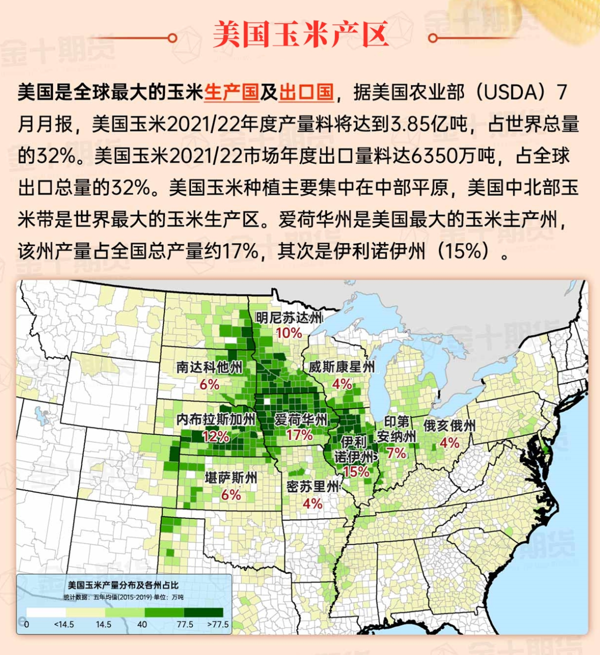
Corn Planting Area of the United States Showers and a few thunderstorms extend southwest from the Upper Midwest. At the same time, warm and mostly dry weather in the eastern corn belt is favorable for late-season corn and soybean planting, as well as winter wheat growth.
 Some areas in California and the Great Basin have sporadic rain and snow, while there are still sporadic precipitation in the northwest. Despite the cold weather in coastal states along the Pacific, field work such as cotton harvesting in unaffected areas (such as California and Arizona) is underway.
Weather Outlook Initially, the active weather in most parts of the United States will eventually consolidate along the cold front sweeping through the central United States on Tuesday. Subsequently, the cold front will reach the coastal states along the Atlantic Ocean on Thursday, although cool and unstable showers will persist in the Great Lakes states for a few days. According to preliminary reports, the United States will breathe a sigh of relief from the continuous thunderstorms that triggered more than 500 tornadoes in May. Before calm weather arrives, precipitation in the eastern half of the United States may reach 1 to 3 inches, except in the southern hinterland. In addition, early heat waves will expand in the western United States this weekend, with maximum temperatures exceeding 110 degrees Fahrenheit and covering lower altitude areas in the desert southwest.
The recent rainfall has ended, and farmers are resuming the final harvest work according to field conditions. In the central and western states, as of November 10, only Wisconsin still has over 10% of corn fields not yet harvested, with 89% of the state's corn harvest completed. The highest temperatures in the central and western states today should be between 50 and 60 degrees Fahrenheit, with the possibility of higher temperatures downstream in the Missouri River Valley.
Map of US Corn Production Areas
In the central Atlantic states, scattered rainfall is gradually coming to an end. In other areas, the mild and dry weather is conducive to late-season field work, including summer crop harvesting and winter Chicago SRW wheat planting. Today's high temperatures should be around 60 degrees Fahrenheit near the Tennessee Valley, while reaching 80 degrees Fahrenheit or higher in the deep south of Florida and southern Texas.
Chicago SRW Wheat and Corn Futures
In the coming days, strong winds, low humidity, and continued dry conditions will increase the risk of fire activity in the northeast. In contrast, recent rainfall has suppressed the threat of fires in parts of the central Appalachian Mountains and central Atlantic states. Meanwhile, a storm system from the western United States will trigger a significant rainfall event in the central part of the country starting from Sunday, covering the southern Rockies and plains areas. Total storm precipitation could reach 1 to 4 inches or more, extending along an axis from the southern plains to the Midwest. While most of the precipitation will fall as rain, snow will cover higher elevations in the southern Rockies. Elsewhere, heavy rain weather will persist in the northwestern part of the Pacific in the next few days.
The 6 to 10-day outlook forecast from the USA National Weather Service from November 20th to 24th predicts that temperatures nationwide may be near or below normal levels, except for temperatures along the Pacific coast and nearby areas, as well as from the Great Lakes region to the central and northern Atlantic states, where temperatures may be above normal levels. At the same time, the western, southern plains, and Mississippi Delta regions may experience near or below normal levels of precipitation, contrasting with above-normal precipitation in the eastern and central regions.
Soybeans should be translated as soybean.

The Atlantic Ocean should be translated as the Atlantic.

Cotton should be translated as cotton.


 加州和大盆地的部分地区出现了零星的雨雪,而西北部仍有零星降水。尽管太平洋沿岸各州的天气寒冷,但在未受雨水影响的地区(如加利福尼亚和亚利桑那 )的棉花收割等田间工作正在进行中。