The 6-10 day outlook forecast from the National Weather Service in the USA for November 19th to 23rd predicts that temperatures in most areas of the western and central regions may be close to or below normal levels.
The following is the agricultural weather forecast for the United States on Thursday, November 14, 2024, exclusively compiled by Golden Ten Futures App.
Western United States Cool and rainy weather extends from the northwestern Pacific to the northern Rockies. This rain is beneficial for crops in the northwest, including winter wheat and small grains sown in the spring. At the same time, the hot weather in the Southwest is beneficial for farming and crop growth, although there is a high wildfire threat in some areas of Arizona and New Mexico.
Unstable and rainy weather persists in the northern parts of the Pacific coast. The rest of the western United States is dry. In many areas, field work for this season is nearing completion, although cotton harvesting in Arizona (completed 73% by November 10) and California (65% completed) is still ongoing.
Corn Planting Area of the United States Showers and a few thunderstorms extend southwest from the Upper Midwest. At the same time, warm and mostly dry weather in the eastern corn belt is favorable for late-season corn and soybean planting, as well as winter wheat growth.
 Mild and dry weather is favorable for end-of-season field work, except in areas where recent rainfall or snowfall has been particularly intense. Some areas in the northern plains still face severe drought issues. As of November 10, 81% of Montana's topsoil moisture rating was classified as extremely dry to dry, while South Dakota was at 77%. On the same date, 75% of winter wheat in South Dakota had emerged (significantly behind the 90% 5-year average level), reflecting the dry conditions.
Weather Outlook Initially, the active weather in most parts of the United States will eventually consolidate along the cold front sweeping through the central United States on Tuesday. Subsequently, the cold front will reach the coastal states along the Atlantic Ocean on Thursday, although cool and unstable showers will persist in the Great Lakes states for a few days. According to preliminary reports, the United States will breathe a sigh of relief from the continuous thunderstorms that triggered more than 500 tornadoes in May. Before calm weather arrives, precipitation in the eastern half of the United States may reach 1 to 3 inches, except in the southern hinterland. In addition, early heat waves will expand in the western United States this weekend, with maximum temperatures exceeding 110 degrees Fahrenheit and covering lower altitude areas in the desert southwest.
Earlier today, the area east of the Mississippi River was experiencing rainfall, where most summer crops had already been harvested. Meanwhile, mild and dry weather covered the western corn belt following recent rainfall. By November 10, winter wheat planting in Missouri was 86% complete, while in Michigan it had reached 100%.
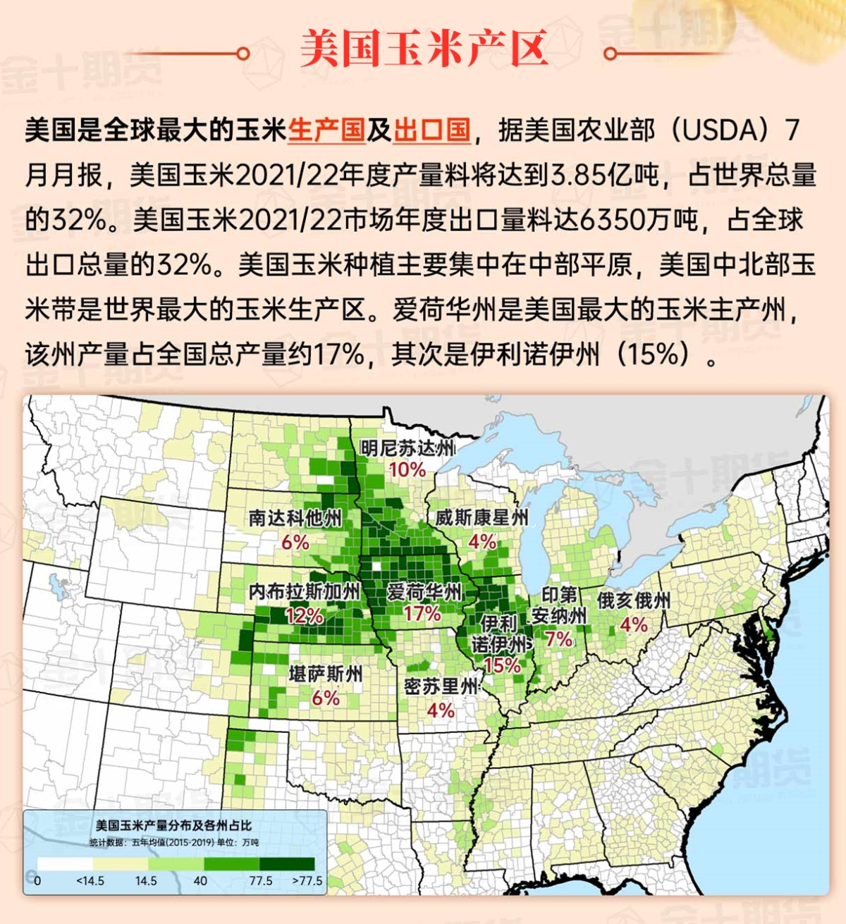
Map of US Corn Production Areas
Showers spreading from the Appalachian Mountains to the southern coast of the atlantic china welding consumables,inc. have caused minor delays in field work in most areas. In fact, the rain has been very beneficial to areas that have experienced almost no rainfall for over 6 weeks since Hurricane Helen passed through in late September. Further west, mild dry weather dominates from the western coast of the Gulf of Mexico to the Mississippi Delta. By November 10th, sugarcane harvesting in Louisiana was already 48% complete, ahead of the 5-year average level of 40%.
Chicago SRW Wheat and Corn Futures
Overall beneficial rain will sweep across the eastern usa from today to Friday, although there will be little to no precipitation in the drought-stricken areas of the northeast, where wildfires have been an ongoing issue. The focus of significant precipitation will soon shift back to parts of the western and central usa. Initially, the heaviest rain and high-altitude snowfall will fall in the Pacific Northwest, although scattered showers might spread to southern California by late weekend. Late weekend and early next week, a significant precipitation event is expected in the central regions, from the Rockies and southern plains to the Midwest, with 1 to 4 inches of precipitation anticipated. Additionally, tropical depression 19 has already formed in the western Caribbean Sea, posing no direct threat to the Gulf Coast of the USA, although this system may enter the Gulf over the next week, interacting extensively with the mainland of Central America and the Yucatán Peninsula.
The 6-10 day outlook forecast by the National Weather Service for November 19-23 predicts that temperatures in much of the western and central regions may be near or below normal levels, while the eastern areas east of the Minnesota-to-Alabama line are expected to experience warmer weather. At the same time, precipitation from the Pacific coast to the plains and Mississippi Delta may be near or below normal levels, contrasting with above-average precipitation in much of the eastern and central regions.
Soybeans should be translated as soybean.

The Atlantic Ocean should be translated as the Atlantic.

Cotton should be translated as cotton.


 温和干燥的天气有利于季末的田间工作,除了近期降雨或降雪特别密集的地区。北部平原地区的部分地区仍然存在严重干旱问题,截至11月10日,蒙大拿州81%的表土湿度评级为极度干燥到干燥,南达科他州为77%。同一日期,南达科他州75%的冬小麦已经发芽(远远落后于90%的5年平均水平),反映了干旱条件。