The National Weather Service's outlook from November 18 to 22 predicts that above-normal temperatures may occur in the eastern part of the usa, while temperatures along the pacific coast to the plateau region may be below normal.
The following is the agriculture weather advisory for the usa on Wednesday, November 13, 2024, exclusively compiled by Jinsun Futures APP.
Western United States Cool and rainy weather extends from the northwestern Pacific to the northern Rockies. This rain is beneficial for crops in the northwest, including winter wheat and small grains sown in the spring. At the same time, the hot weather in the Southwest is beneficial for farming and crop growth, although there is a high wildfire threat in some areas of Arizona and New Mexico.
A storm system is approaching, bringing significant precipitation, including snowfall in the high-altitude regions of the northwest of the pacific. The rest of the region is experiencing cool and dry weather. Almost all planned winter wheat planting areas in the northwest have been completed, and as of November 10, cotton harvesting in california has reached 65%.
Corn Planting Area of the United States Showers and a few thunderstorms extend southwest from the Upper Midwest. At the same time, warm and mostly dry weather in the eastern corn belt is favorable for late-season corn and soybean planting, as well as winter wheat growth.
 Mild weather is conducive to late fall fieldwork, except in areas with rain or snow accumulation still on the ground. Earlier today, rain was primarily concentrated in the eastern plains, while snow in the central highlands is gradually melting. Significant improvements in soil moisture have led to more favorable conditions for the emergence and growth of winter wheat. As of November 10, 44% of the national winter wheat was rated good to excellent, up from 38% on October 27. However, there are still some significant drought areas in the northern plains.
Weather Outlook Initially, the active weather in most parts of the United States will eventually consolidate along the cold front sweeping through the central United States on Tuesday. Subsequently, the cold front will reach the coastal states along the Atlantic Ocean on Thursday, although cool and unstable showers will persist in the Great Lakes states for a few days. According to preliminary reports, the United States will breathe a sigh of relief from the continuous thunderstorms that triggered more than 500 tornadoes in May. Before calm weather arrives, precipitation in the eastern half of the United States may reach 1 to 3 inches, except in the southern hinterland. In addition, early heat waves will expand in the western United States this weekend, with maximum temperatures exceeding 110 degrees Fahrenheit and covering lower altitude areas in the desert southwest.
Cold rain is emerging in parts of the northern midwest. Meanwhile, producers are concluding the 2024 harvest season, and as of November 10, 95% of corn and 96% of soybean have been harvested in the usa, with soybean harvesting completed in minnesota and the dakotas.
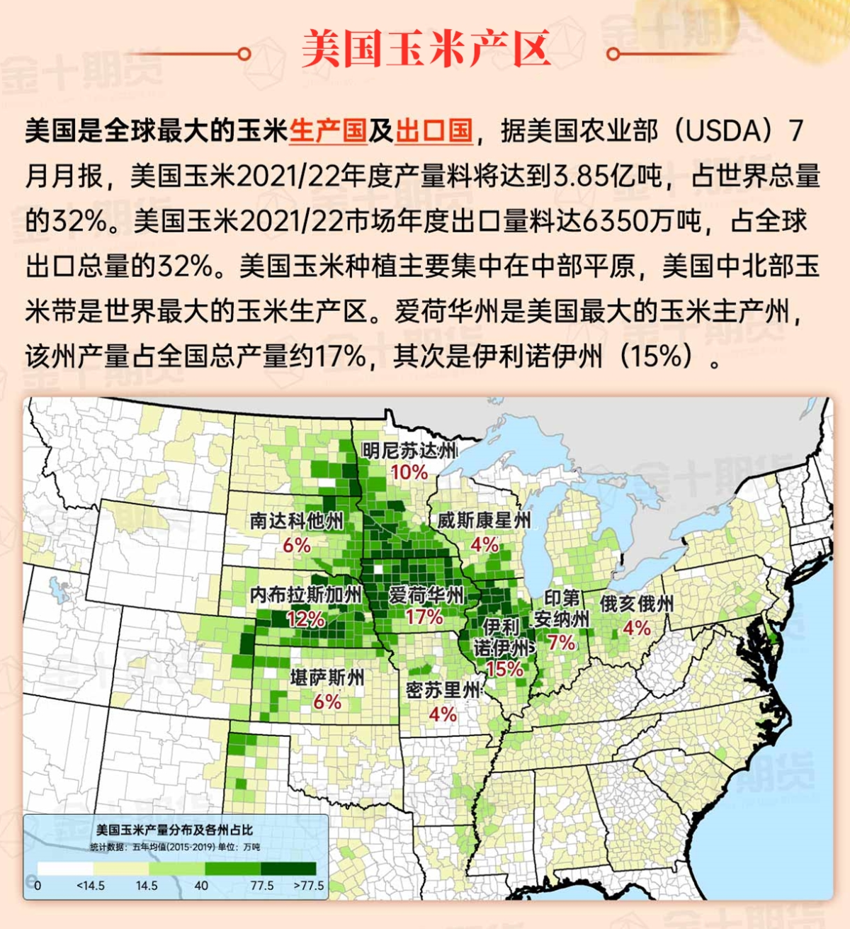
Map of US Corn Production Areas
The persistent warmth is limited to areas near the coast of the Gulf of Mexico. Meanwhile, earlier reports indicated that there were isolated frosts in southern North Carolina. Although the peanut harvest is slightly delayed, fieldwork in the south has experienced hardly any delays. As of November 10, the usa peanut harvest was completed at 82%, compared to a 5-year average of 85%.
Chicago SRW Wheat and Corn Futures
In the northeast, some areas still face a higher threat of wildfires, with the Jennings Creek fire burning about 5,000 acres of vegetation on both sides of the New York-New Jersey border. At the same time, a storm system forming in the Midwest will drift eastward, arriving at the atlantic mid-coast early Friday. Typically beneficial showers will help to moisten the Midwest, the atlantic mid-region, and the southeast, but the drought-stricken northeast will remain mostly dry. Moving west, a pacific storm moving inland will produce widespread precipitation extending into the weekend, briefly stretching into southern California. Next weekend and early next week, as storm activity spreads eastward, significant precipitation events may occur in the midwest, the southern rocky mountains, and the plains. Elsewhere, meteorologists continue to monitor the potential development of a heat wave over the Caribbean, which may impact certain areas along the usa Gulf Coast.
The usa National Weather Service's 6-10 day outlook for November 18 to 22 predicts that above-normal temperatures may occur in the eastern half of the usa, while temperatures along the pacific coast to the plateau region are expected to be below normal. Meanwhile, precipitation across much of the country may be near or above normal, while northern California, the northern great basin, and northwestern regions may see precipitation below normal.
Soybeans should be translated as soybean.

The Atlantic Ocean should be translated as the Atlantic.

Cotton should be translated as cotton.


 温和的天气有利于晚秋田间工作,除了降雨区域或积雪仍在地面上的地区。今天早些时候,降雨主要集中在东部平原地区,而中部高原地区的积雪正在逐渐融化。土壤湿度的显著改善导致了更有利于冬小麦的出苗和生长条件。截至11月10日,全国冬小麦中有44%被评为良好至优秀的状态,高于10月27日的38%。然而,在北部平原地区仍然存在一些显著的干旱区域。