The 6-10 day outlook forecast from the USA National Weather Service from November 17th to 21st predicts that temperatures in the western USA may be below normal levels, while the eastern region is expected to generally experience above normal weather.
The following is the exclusive compilation of the US agricultural weather forecast for Tuesday, November 12, 2024, by Jinshi Futures APP.
Western United States Cool and rainy weather extends from the northwestern Pacific to the northern Rockies. This rain is beneficial for crops in the northwest, including winter wheat and small grains sown in the spring. At the same time, the hot weather in the Southwest is beneficial for farming and crop growth, although there is a high wildfire threat in some areas of Arizona and New Mexico.
Precipitation is affecting the northern parts of the Pacific Northwest and western mountains, with snowfall in high-altitude areas. Meanwhile, parts of the central and southern Rockies and Rocky Mountains are still clearing the remnants of last week's heavy snowfall, with total snow accumulations reaching 3 to 5 feet or more in some high-altitude areas. In other areas, strong winds are presenting a renewed wildfire threat in parts of southern California, with the largest fire last week in Ventura County, with a destructive area of 20,630 acres, now over 40% contained.
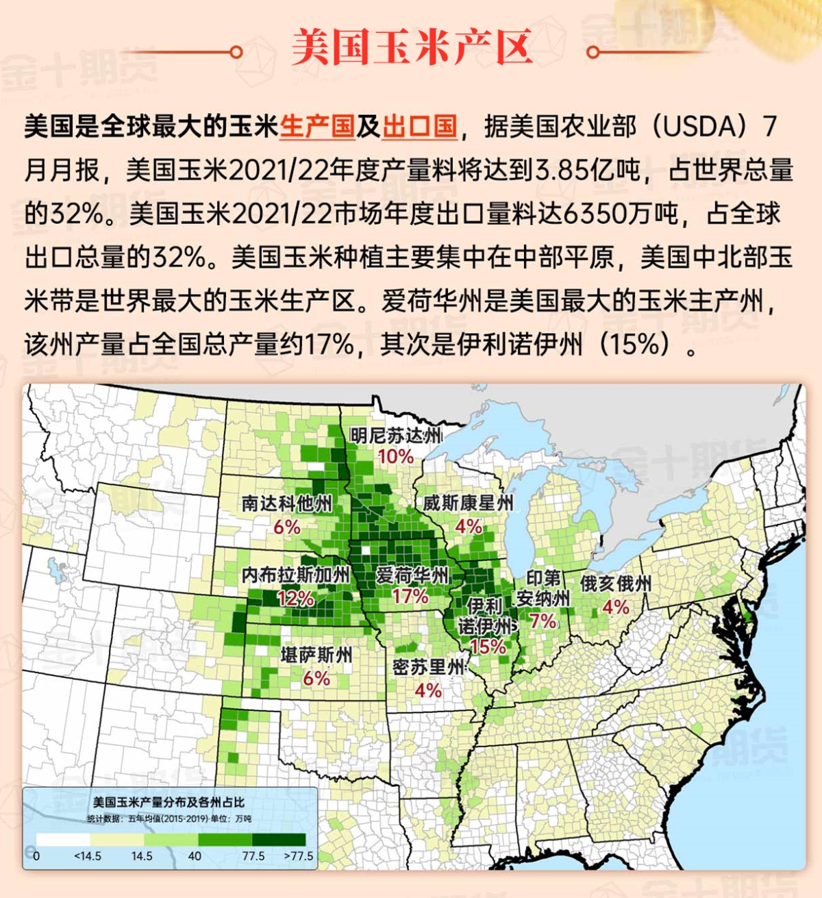
Corn Planting Area of the United States Showers and a few thunderstorms extend southwest from the Upper Midwest. At the same time, warm and mostly dry weather in the eastern corn belt is favorable for late-season corn and soybean planting, as well as winter wheat growth.
 Isolated light precipitation is spreading to Montana. Dry weather prevails in the central remaining areas of the region. However, there are still significant snow accumulations in the central and southern high plains areas. From November 5 to 9, Denver, Colorado received a total snowfall of 20.0 inches, while Colorado Springs received 19.3 inches, briefly increasing pressure on livestock but providing much-needed moisture for ranches, pastures, and winter wheat.
Weather Outlook Initially, the active weather in most parts of the United States will eventually consolidate along the cold front sweeping through the central United States on Tuesday. Subsequently, the cold front will reach the coastal states along the Atlantic Ocean on Thursday, although cool and unstable showers will persist in the Great Lakes states for a few days. According to preliminary reports, the United States will breathe a sigh of relief from the continuous thunderstorms that triggered more than 500 tornadoes in May. Before calm weather arrives, precipitation in the eastern half of the United States may reach 1 to 3 inches, except in the southern hinterland. In addition, early heat waves will expand in the western United States this weekend, with maximum temperatures exceeding 110 degrees Fahrenheit and covering lower altitude areas in the desert southwest.
Cool and dry weather is widespread, although cloudy conditions persist in the Great Lakes region. Today's high temperatures range from around 45°F in the Great Lakes region to 60°F or higher downstream of the Missouri River Valley in the Midwest. With the return of dry weather, farmers are attempting to complete the remaining summer crop harvest.
Map of US Corn Production Areas
Hurricane Raphael dissipated in the central Gulf of Mexico over the weekend, although some residual tropical moisture generated showers along the coast and nearby areas of the Gulf of Mexico. In other areas, warm and humid conditions persist in the deep south, while cooler, drier air has diffused into the central and southern states along the Atlantic coast. Agricultural activities include summer crop harvesting and winter wheat planting.
Chicago SRW Wheat and Corn Futures
In the coming days, the threat of wildfires in northeastern parts of the country will continue to intensify, with several fires burning, including the Jennings Creek fire near West Milford, New Jersey. The next chance for rain in the northeast will be on Thursday and Friday. Meanwhile, much of the eastern half of the country will experience brief showers starting from Wednesday, spreading eastward from the Mississippi Valley. In other regions, the northern half of the western United States will see cool, unstable weather, with higher elevations in the northwest expected to receive snow mid-week. Southern and southwestern parts of California will also remain cool, although mostly dry.
The 6-10 day outlook forecast by the National Weather Service from November 17th to 21st indicates that temperatures in the western United States may be below normal, while the eastern part will generally experience above-normal weather. At the same time, much of the country will have precipitation levels close to or above normal, contrasting sharply with below-normal dry weather along the northern Atlantic coast.
Soybeans should be translated as soybean.

The Atlantic Ocean should be translated as the Atlantic.

Cotton should be translated as cotton.


 零星的轻微降水正在蔓延到蒙大拿州。干燥的天气覆盖了该地区中部其余地区。然而,中部和南部高原地区仍有大量积雪。11月5日至9日,科罗拉多州丹佛降雪量总计为20.0英寸,科罗拉多斯普林斯降雪量总计为19.3英寸,短暂增加了牲畜的压力,但为牧场、草地和冬小麦提供了急需的水分。