The 6-10 day outlook from November 5th to 9th by the National Weather Service of the usa shows that precipitation in most areas of the usa is near or above normal levels.
The following is the agriculture weather forecast for the United States on Thursday, October 31, 2024, exclusively compiled by Golden Ten Futures App.
Western United States Cool and rainy weather extends from the northwestern Pacific to the northern Rockies. This rain is beneficial for crops in the northwest, including winter wheat and small grains sown in the spring. At the same time, the hot weather in the Southwest is beneficial for farming and crop growth, although there is a high wildfire threat in some areas of Arizona and New Mexico.
As a Pacific storm system approaches, precipitation has diffused into the northern Rocky Mountains and the southern part of Northern California. Unstable weather, along with below-normal temperatures, is accompanied by cool yet dry weather conducive to autumn field operations in California and the Southwest, including cotton harvesting.
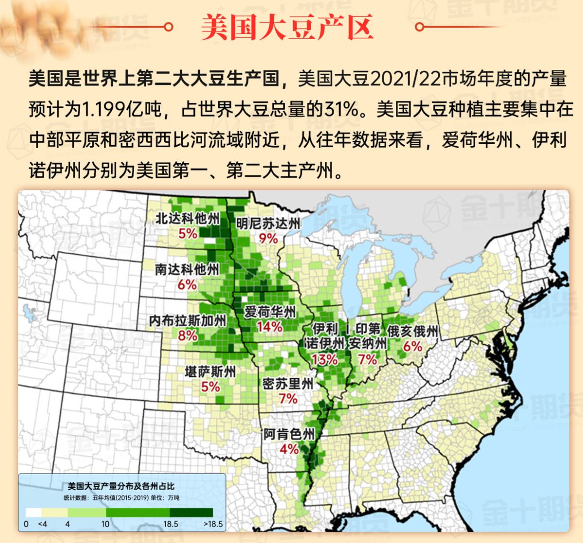
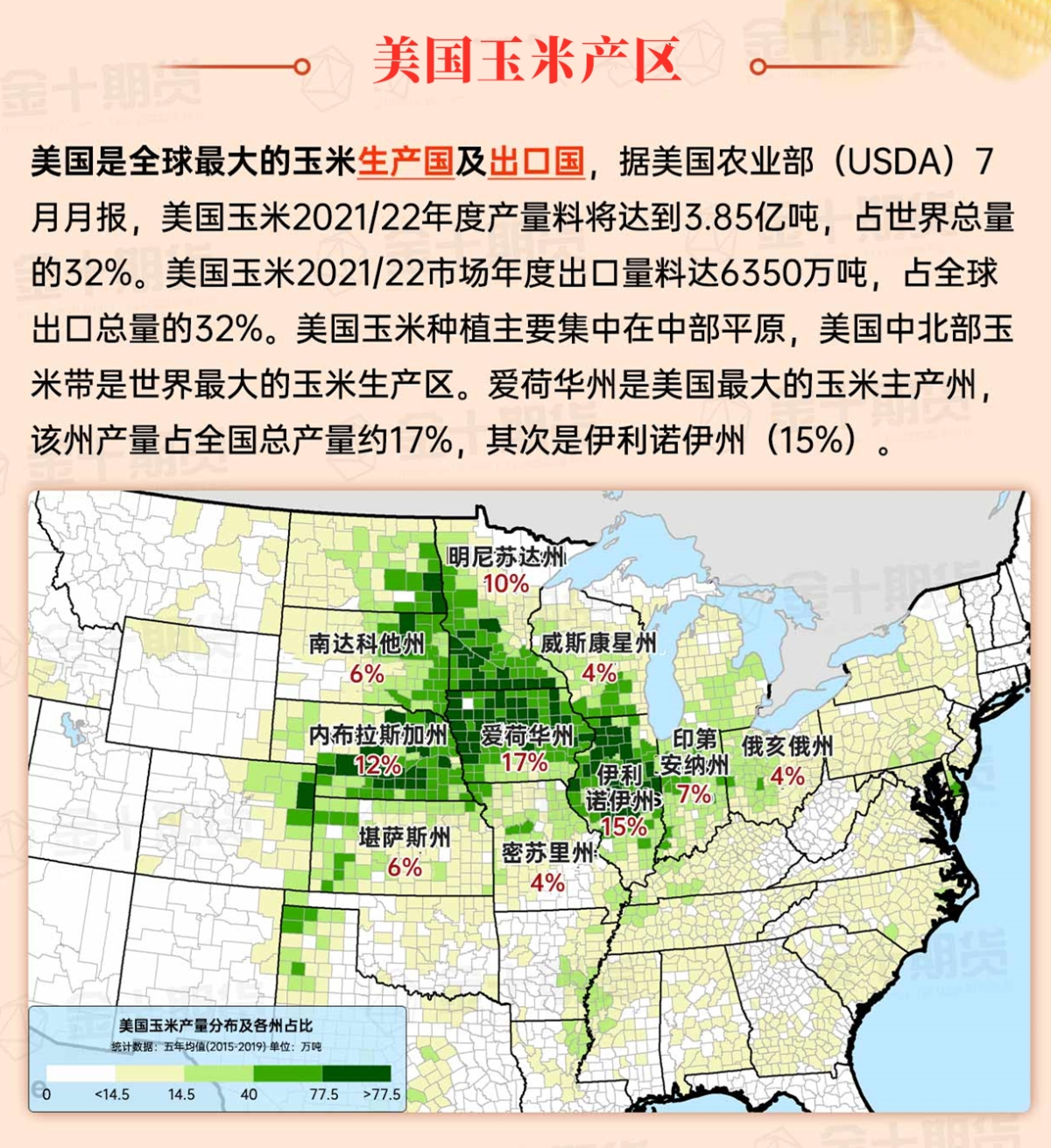
Corn Planting Area of the United States Showers and a few thunderstorms extend southwest from the Upper Midwest. At the same time, warm and mostly dry weather in the eastern corn belt is favorable for late-season corn and soybean planting, as well as winter wheat growth.
 Cool weather prevails after the cold front. Earlier today, frost extended to the southern high plains and entered a narrow band in northern Texas. Any recent precipitation associated with the cold front is mainly confined to the eastern Great Plains, leaving many key winter wheat production areas lacking the necessary moisture for proper autumn emergence and establishment of soil moisture. As of October 27, winter wheat emergence in Oklahoma, Nebraska, South Dakota, and Texas lags more than 5 percentage points below average.
Weather Outlook Initially, the active weather in most parts of the United States will eventually consolidate along the cold front sweeping through the central United States on Tuesday. Subsequently, the cold front will reach the coastal states along the Atlantic Ocean on Thursday, although cool and unstable showers will persist in the Great Lakes states for a few days. According to preliminary reports, the United States will breathe a sigh of relief from the continuous thunderstorms that triggered more than 500 tornadoes in May. Before calm weather arrives, precipitation in the eastern half of the United States may reach 1 to 3 inches, except in the southern hinterland. In addition, early heat waves will expand in the western United States this weekend, with maximum temperatures exceeding 110 degrees Fahrenheit and covering lower altitude areas in the desert southwest.
Damp and noticeably cool weather has temporarily interrupted the final corn and soybean harvest. In parts of Minnesota and Wisconsin, precipitation has begun to change to wet snow. Any remnants of warm weather are confined to the Eastern Corn Belt with the advance of an approaching cold front. Despite field operations coming to a sudden halt, many producers in the Midwest welcome the first significant rainfall of the month. As of October 27, dry autumn weather has led to at least 80% of topsoil moisture in Illinois, Iowa, Nebraska, Ohio, and South Dakota being rated as very short to short.
Map of US Corn Production Areas
Showers and thunderstorm activity are spreading to areas west of the Mississippi River, slowing down field operations but providing much-needed moisture for winter grains and cover crops. Meanwhile, in the southeast, warm, dry weather continues to promote summer crop harvesting, winter wheat planting, and hurricane recovery efforts.
Chicago SRW Wheat and Corn Futures
A cold front extending from the central region to Texas will move eastward and weaken, with rainfall coverage and intensity rapidly decreasing as it approaches and crosses the Appalachian Mountains. Meanwhile, a new storm system and its associated cold front will arrive in the west over the weekend and reach the Great Plains early next week. This system will also weaken before reaching the eastern United States. As a result, there will be a steep gradient between continued dry weather in much of the eastern regions and precipitation totals of 2 to 4 inches or more from the southern Great Plains to the upper Midwest. Most of the western United States will also see some precipitation, including snow in higher elevations, with the highest rainfall expected in northern California and the northwest.
The 6-10 day outlook forecast from November 5th to 9th by the National Weather Service indicates that temperatures will be near or below normal from the Pacific coast to the high plains, while temperatures in half of the eastern United States will be above normal. At the same time, precipitation across much of the country will be near or above normal, contrasting with dry conditions along the Pacific coastal states, western Great Basin, and the central and northern Atlantic coast.
Soybeans should be translated as soybean.

The Atlantic Ocean should be translated as the Atlantic.

Cotton should be translated as cotton.


 冷锋过后,凉爽天气盛行。今天早些时候,霜冻现象一直延伸到南部高地平原,进入德克萨斯州北部的狭长地带。与冷锋相关的任何近期降水主要限于东部大平原,使得许多关键的冬小麦生产区域仍然缺乏适当的秋季出苗和建立所需的土壤水分。截至10月27日,俄克拉荷马州、内布拉斯加州、南达科他州和德克萨斯州的冬小麦出苗比平均值落后5个百分点以上。