The 6-10 day outlook from November 3rd to 7th by the National Weather Service of usa shows that there is a possibility of temperatures near or above normal in the central and eastern regions of the country, while most of the western areas will experience temperatures below normal.
The following is the agricultural weather forecast for the United States on Tuesday, October 29, 2024, exclusively compiled by Golden Ten Futures App.
Western United States Cool and rainy weather extends from the northwestern Pacific to the northern Rockies. This rain is beneficial for crops in the northwest, including winter wheat and small grains sown in the spring. At the same time, the hot weather in the Southwest is beneficial for farming and crop growth, although there is a high wildfire threat in some areas of Arizona and New Mexico.
Heavy snow covers the Great Basin, the inland western region, and the central Rocky Mountains in mountainous areas, while lower altitude areas experience rainfall. After several weeks of dry weather, precipitation has reduced the threat of wildfires and improved surface soil moisture. As of October 27, the surface soil moisture in Wyoming was rated as 90%, ranging from very short to short.
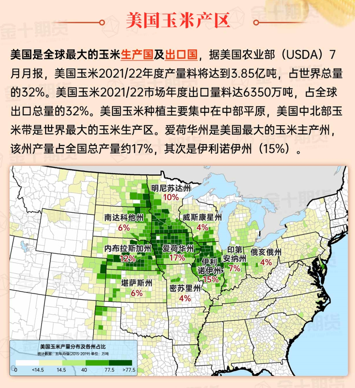
Corn Planting Area of the United States Showers and a few thunderstorms extend southwest from the Upper Midwest. At the same time, warm and mostly dry weather in the eastern corn belt is favorable for late-season corn and soybean planting, as well as winter wheat growth.
 Scattered showers have slowed down the rapid field work pace in South Dakota and surrounding areas. As of October 27, sugar beet harvest in North Dakota was 95% complete, exceeding the 85% five-year average. By that date, sunflower harvest in the United States was 47% complete, compared to a 40% five-year average. Meanwhile, continued warm and dry conditions in the southeastern part of the Great Plains have led to delays in winter wheat planting related to drought, as well as issues with crop emergence and establishment. Nationally, as of October 27, 23% of winter wheat was rated very poor to poor condition, with higher values in Texas (35%), Oklahoma (33%), and Nebraska (29%).
Weather Outlook Initially, the active weather in most parts of the United States will eventually consolidate along the cold front sweeping through the central United States on Tuesday. Subsequently, the cold front will reach the coastal states along the Atlantic Ocean on Thursday, although cool and unstable showers will persist in the Great Lakes states for a few days. According to preliminary reports, the United States will breathe a sigh of relief from the continuous thunderstorms that triggered more than 500 tornadoes in May. Before calm weather arrives, precipitation in the eastern half of the United States may reach 1 to 3 inches, except in the southern hinterland. In addition, early heat waves will expand in the western United States this weekend, with maximum temperatures exceeding 110 degrees Fahrenheit and covering lower altitude areas in the desert southwest.
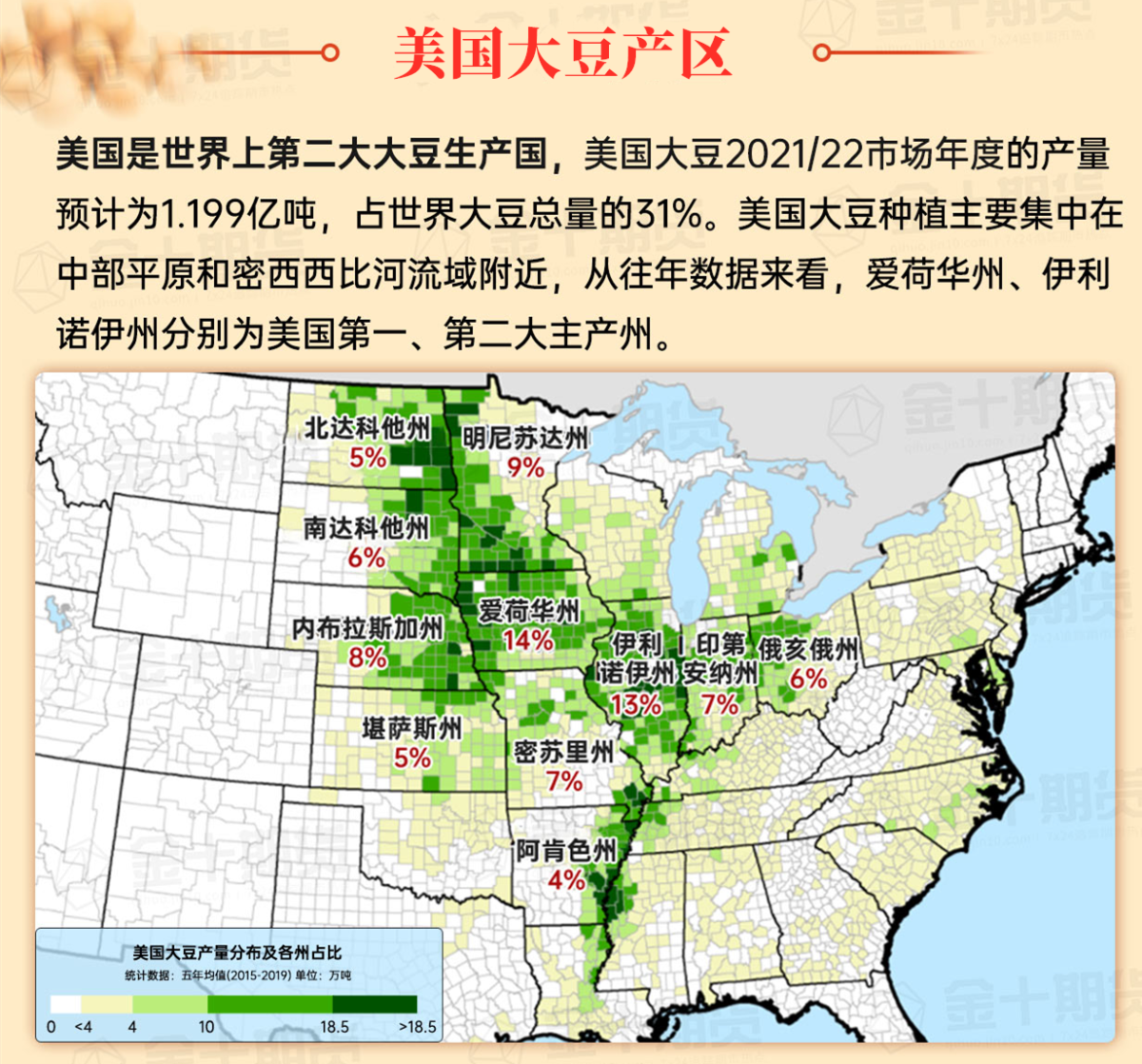
Despite an increase in cloud cover, warm and dry weather is facilitating field work. Today's high temperatures will reach 80°F or higher, extending to the southeastern parts of Minnesota and central Wisconsin. As of October 27, soybean harvest in the United States was 89% complete - the fastest pace since 2010, when 93% of the crop was harvested by that date.
Map of US Corn Production Areas
Some showers are lurking near the Atlantic china welding consumables,inc. coast. In other areas, warm and dry weather has promoted autumn field work, but reduced soil moisture for pastures and autumn crops. As of October 27, in the main production states, 53% of winter chicago srw wheat in Arkansas was rated as very poor to poor. On the same day, except for Florida, the surface soil moisture in each southern state was rated as over half very short to short.
Chicago SRW Wheat and Corn Futures
Pattern changes will bring more precipitation opportunities to the Great Plains and Midwest regions of the usa, while the weather in the western regions will turn cooler. The total rainfall over the next five days may reach 1 to 2 inches or more from the southern plains to the Upper Great Lakes states, and similar rainfall will eventually diffuse downstream to the Mississippi River Valley. Meanwhile, late warm weather will persist before unstable weather affects the central usa region. Warm (and dry) conditions in the east will persist for most of the week. In other areas, a new round of precipitation will cover northern California and the Northwest region later this week, with snow expected in high-altitude areas ranging from the Cascades and Sierra Nevada to the northern Rockies.
The 6-10 day outlook forecast from the National Weather Service from November 3rd to 7th predicts a likelihood of near or above normal temperatures in the central and eastern parts of the usa, while much of the western regions will experience below normal temperatures. Simultaneously, precipitation across most of the country will be near or above normal levels, contrasting with the dry weather in northern California, the northern part of the Great Basin, parts of the Northwest, and along the Atlantic china welding consumables,inc. coastline.
Soybeans should be translated as soybean.

The Atlantic Ocean should be translated as the Atlantic.

Cotton should be translated as cotton.


 零星的阵雨减缓了达科他州及周边地区之前快速的田间工作节奏。截至10月27日,北达科他州的甜菜收获已完成95%,超过5年平均值85%。在该日期,美国向日葵收获完成了47%,相比之下,5年平均值为40%。与此同时,大平原东南部持续的温暖干燥条件导致了一些与干旱相关的冬小麦种植延迟,以及与作物出苗和成苗相关的问题。在全国范围内,截至10月27日,23%的冬小麦被评为状况非常差至差,德克萨斯州(35%)、俄克拉荷马州(33%)和内布拉斯加州(29%)的值更高。