The 6-10 day outlook from November 2nd to 6th by the USA National Weather Service shows that the central and eastern USA may experience temperatures close to or above normal levels, while the western part will have cooler conditions than normal.
The following is the agricultural weather forecast for the usa on Monday, October 28, 2024, exclusively compiled by GoldenTen Futures App.
Western United States Cool and rainy weather extends from the northwestern Pacific to the northern Rockies. This rain is beneficial for crops in the northwest, including winter wheat and small grains sown in the spring. At the same time, the hot weather in the Southwest is beneficial for farming and crop growth, although there is a high wildfire threat in some areas of Arizona and New Mexico.
A cooler and more unstable weather pattern is emerging. Temperatures are below normal in California and the Northwest, while rain is spreading inland along the north Pacific coast. Parts of the northern and southwestern regions of the Great Basin are experiencing varying levels of precipitation. The increase in precipitation brings benefits such as reducing the threat of wildfires and improving conditions for pastures and grasslands.
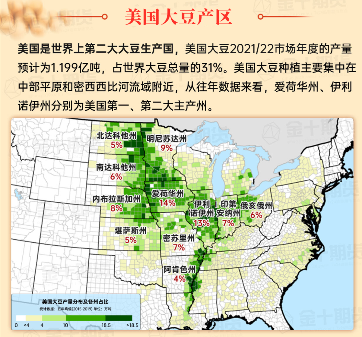
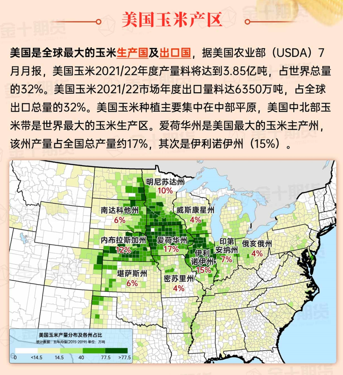
Corn Planting Area of the United States Showers and a few thunderstorms extend southwest from the Upper Midwest. At the same time, warm and mostly dry weather in the eastern corn belt is favorable for late-season corn and soybean planting, as well as winter wheat growth.
 Despite an increase in cloud cover, unseasonably warm weather continues to prevail. This warm weather comes after several weeks of mostly dry conditions, leading to widespread water shortages for crops planted in the autumn, including winter Chicago SRW wheat. As the wind picks up later today, the threat of wildfires will also increase, especially in the southern regions of the Great Plains.
Weather Outlook Initially, the active weather in most parts of the United States will eventually consolidate along the cold front sweeping through the central United States on Tuesday. Subsequently, the cold front will reach the coastal states along the Atlantic Ocean on Thursday, although cool and unstable showers will persist in the Great Lakes states for a few days. According to preliminary reports, the United States will breathe a sigh of relief from the continuous thunderstorms that triggered more than 500 tornadoes in May. Before calm weather arrives, precipitation in the eastern half of the United States may reach 1 to 3 inches, except in the southern hinterland. In addition, early heat waves will expand in the western United States this weekend, with maximum temperatures exceeding 110 degrees Fahrenheit and covering lower altitude areas in the desert southwest.
Late-season warm weather is replacing brief cool spells. In most parts of Missouri today, temperatures will exceed 80°F, while in central Minnesota and northern Wisconsin, temperatures may reach 70°F or higher. Meanwhile, the ongoing dry weather in the autumn continues to accelerate the pace of corn and soybean harvesting in the usa.
Map of US Corn Production Areas
Cool weather continues from the Appalachian Mountains to Virginia and North Carolina. In contrast, record warm weather has returned from the western coast of the Gulf of Mexico to the Mississippi Delta region, with today's high temperatures approaching or reaching 90°F. In the ongoing dryness, field work in the south is progressing rapidly, but the shortage of soil moisture west of the Appalachian Mountains has had adverse effects on some pastures and crops for fall planting.
Chicago SRW Wheat and Corn Futures
The more active weather pattern underway in the western United States will move eastward as the week progresses. By midweek, there should be a continuous band of rain from the Great Lakes region to the western Gulf of Mexico region, with total rainfall expected to reach 1 to 2 inches. Subsequently, the rain will move eastward, with coverage and intensity decreasing, and minimal to no rainfall expected in the Midwest and the southern Atlantic states. Despite temporarily slowing down autumn field work, the benefits will include reducing wildfire threats and providing more moisture for pastures, winter wheat, and cover crops. Prior to this week's rainfall, warm weather will first arrive, while cooler and rainier weather will establish further into the western regions.
The 6-10 day outlook forecast from November 2 to 6 by the National Weather Service indicates that the central and eastern United States may experience temperatures close to or above normal levels, while the western regions will have cooler conditions compared to normal levels. Simultaneously, regions across the country with near or above normal precipitation levels contrast with drier weather than normal in Northern California, the Pacific Northwest, and the mid-Atlantic coastal areas.
Soybeans should be translated as soybean.

The Atlantic Ocean should be translated as the Atlantic.

Cotton should be translated as cotton.


 尽管云量增加,但非季节性的暖和天气仍然盛行。这种暖和天气伴随着几周的大部分干燥天气,导致秋季播种的作物(包括冬小麦)普遍缺乏水分。随着今天晚些时候风力的增加,野火威胁也会增加,特别是在大平原的南部地区。