The 6-10 day outlook from October 30th to November 3rd by the USA National Weather Service shows that temperatures will be above normal in half of the eastern United States as well as the central and southern plains, while cooler conditions than normal will prevail in the west.
The following is the U.S. agricultural weather forecast for Friday, October 25, 2024, exclusively compiled by Golden Ten Futures App.
Western United States Cool and rainy weather extends from the northwestern Pacific to the northern Rockies. This rain is beneficial for crops in the northwest, including winter wheat and small grains sown in the spring. At the same time, the hot weather in the Southwest is beneficial for farming and crop growth, although there is a high wildfire threat in some areas of Arizona and New Mexico.
The persistent abnormal warmth is mainly limited to Southern California and the Southwest region. The entire region is experiencing predominantly dry weather, although precipitation is expected along the northern Pacific coast soon. Fieldwork includes the final winter chicago srw wheat planting in the northwest region and cotton harvesting in Arizona and California.
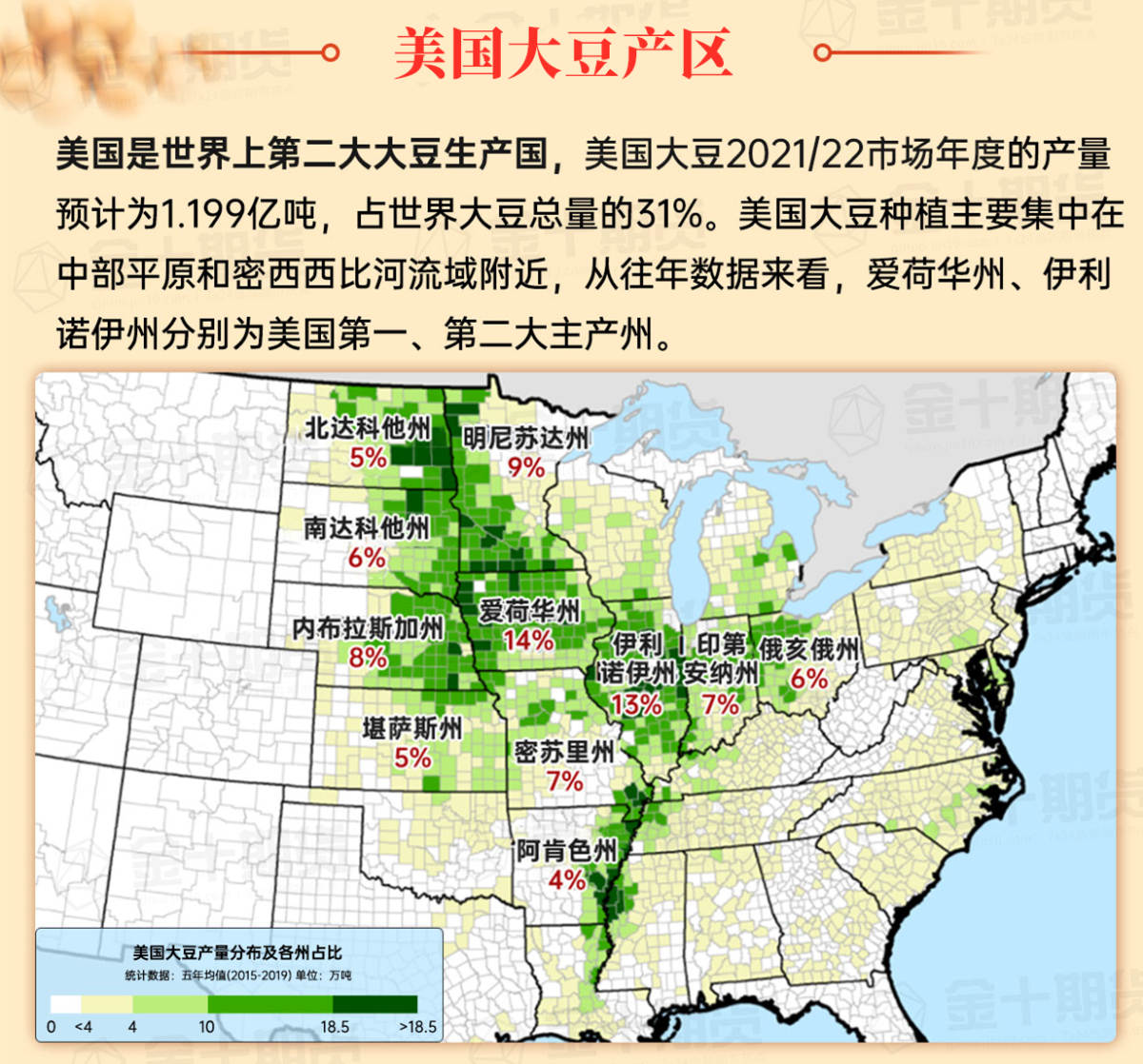
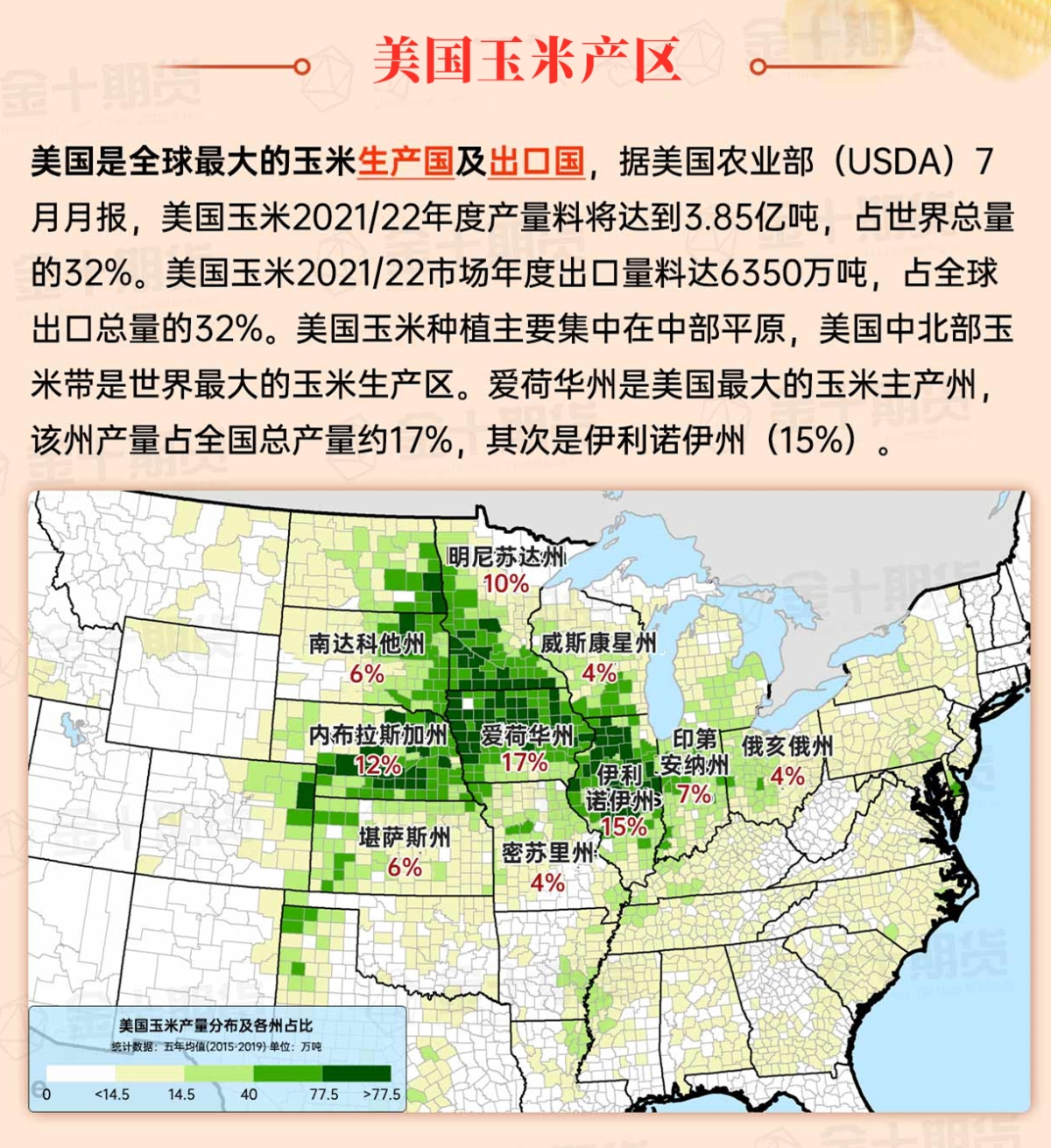
Corn Planting Area of the United States Showers and a few thunderstorms extend southwest from the Upper Midwest. At the same time, warm and mostly dry weather in the eastern corn belt is favorable for late-season corn and soybean planting, as well as winter wheat growth.
 Summer-like warmth is only limited to certain areas of Texas. On Thursday, the last day of widespread high temperatures in the central and southern Plains region, record highs on October 24 included 95°F in Medicine Lodge, Kansas, as well as 94°F in Lawton, Oklahoma, and Lubbock, Texas. Despite cooler air now covering most of the central U.S., temperatures are not unusually low. In addition, insufficient soil moisture continues to hinder the normal growth of winter chicago srw wheat, with some producers waiting for rain before planting.
Weather Outlook Initially, the active weather in most parts of the United States will eventually consolidate along the cold front sweeping through the central United States on Tuesday. Subsequently, the cold front will reach the coastal states along the Atlantic Ocean on Thursday, although cool and unstable showers will persist in the Great Lakes states for a few days. According to preliminary reports, the United States will breathe a sigh of relief from the continuous thunderstorms that triggered more than 500 tornadoes in May. Before calm weather arrives, precipitation in the eastern half of the United States may reach 1 to 3 inches, except in the southern hinterland. In addition, early heat waves will expand in the western United States this weekend, with maximum temperatures exceeding 110 degrees Fahrenheit and covering lower altitude areas in the desert southwest.
Spotty showers from the Great Lakes region to the central Mississippi River valley have temporarily delayed fieldwork. However, the precipitation is typically light and brief, with no significant impact on the ongoing development of the drought in the central and western U.S. This drought has facilitated the fastest U.S. soybean harvest to date— as of October 20, 81% of soybeans have been harvested— the fastest since 2010 when 86% of the crop had been harvested by that date.
Map of US Corn Production Areas
The dry weather and record high temperatures are almost ideal for field work, although some newly planted winter grains and cover crops—especially those west of the Mississippi Delta—lack the necessary moisture for proper autumn growth. Today's high temperatures typically range from 85 to 90°F, with slightly cooler conditions in Virginia and North Carolina.
Chicago SRW Wheat and Corn Futures
After scattered showers today, the coming days will bring back dry weather to the central and western regions. Dry conditions will also dominate the rest of the country over the weekend. However, early next week, some significant changes will begin occurring, starting from the northwest. By Monday, the western regions should see widespread showers of rain and snow, with precipitation extending to the northern plains and the upper Midwest by Tuesday. Cooler weather will accompany and follow the precipitation, while abnormal warmth will linger in the southern, eastern, and lower half of the central western regions.
The 6-10 day outlook forecast from the National Weather Service for October 30 to November 3 predicts above-normal temperatures for half of the eastern United States as well as the central and southern plains, while the western regions will experience cooler conditions than usual. Meanwhile, most parts of the country are expected to have near or above-normal precipitation, forming a contrast with the persistently drier-than-normal weather in the central and northern Atlantic coastal areas. The plains and parts of the central western regions are most likely to experience wet weather.
Soybeans should be translated as soybean.

The Atlantic Ocean should be translated as the Atlantic.

Cotton should be translated as cotton.


 类似夏季的温暖仅限于德克萨斯州部分地区。周四,在中部和南部平原地区普遍高温的最后一天,10月24日创纪录的高温包括堪萨斯州梅迪辛洛奇的95°F、俄克拉荷马州劳顿和德克萨斯州拉伯克的94°F。尽管较凉爽的空气已经覆盖了美国中部大部分地区,但气温并不异常低。此外,土壤湿度不足仍然是冬小麦正常生长的障碍,一些生产者在种植前等待雨水。