The US National Weather Service's 6-10 day forecast from October 29 to November 2 shows that the central and eastern parts of the US may experience higher than normal temperatures, while the western part will cover lower than normal conditions.
The following are US agricultural weather tips for Thursday, October 24, 2024, compiled exclusively by the Jin10 Futures App
Western US region
Continued warmth is mostly confined to the Four Corners. Meanwhile, temperatures in the northwest and northern California and the Great Basin are below normal. Despite the cooler weather in the northwest, surface soil moisture in Wyoming was rated 93% extremely deficient to lacking on October 20, followed by Washington State (72%) and Oregon (70%).
American Plains
 Most of Montana, Wyoming, and Dakota are covered by extensive clouds, albeit with only light, scattered showers. Meanwhile, record warming in the southern part of the region has further reduced the water availability of recently grown winter wheat. Wichita Falls (95°F), Lubbock (93°F), and Abilene (91°F) in Texas set daily record highs on October 23.
American corn growing belt
The mild, dry weather has allowed many Midwestern producers to finish this year's soybean harvest ahead of schedule. As of October 20, 81% of the country's soybeans had been harvested, far higher than the 5-year average rate of 67%. Meanwhile, late summer and fall droughts adversely affected many Midwestern ranches. As of October 20, ranches in Ohio were rated 66% extremely barren to poor, 57% in Nebraska, and 51% in South Dakota.
Southern region of the United States
Very warm, dry weather prevails. In fact, today's high temperature should be above 90°F in parts of the western Gulf Coast region. Many producers are actively harvesting summer crops and growing winter crops and cover crops under ideal conditions, although soil moisture reserves are declining. As of October 20, with the exception of Florida (20% extremely deficient to lacking), Virginia (26%), North Carolina (38%), and Kentucky (42%), more than 50% of surface soil moisture was rated as extremely deficient to lacking.
Weather outlook
Over the next 5 days, many regions, including the Plains, South, and Atlantic states, will remain largely dry. However, parts of the Midwest will experience mostly light rainfall from later today to Friday, followed by significant precipitation in the northwestern Pacific over the weekend. By early next week, a storm system will bring some rain and snow as it crosses the western outback of the US. Meanwhile, as the rapidly moving cold front crosses the country, the temperature will fluctuate, and the western region will welcome the coldest air of the season early next week.
The US National Weather Service predicts the 6-10 day forecast for October 29 to November 2. Most areas from the plains to the east coast may be above normal, while the western region will cover conditions below normal. Meanwhile, near-normal or higher-than-normal precipitation in most parts of the country should contrast dry weather in California and the central and northern Atlantic states. The Upper Midwest region is most likely to experience wet weather.
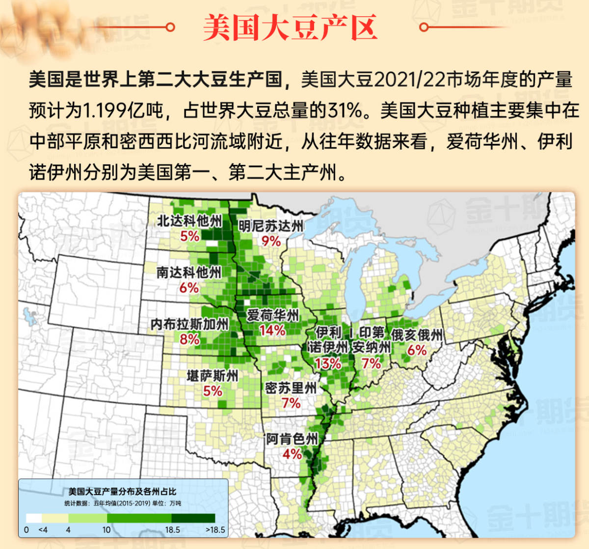
Map of soybean growing regions in the United States

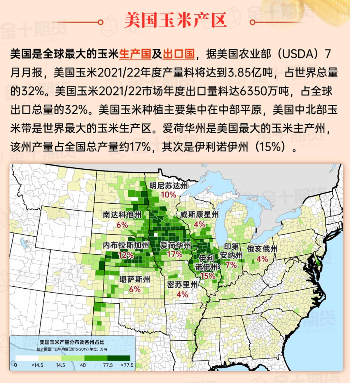
Map of corn growing regions in the United States

Map of cotton growing regions in the United States


 蒙大拿州、怀俄明州和达科他州大部分地区被广泛云层覆盖,尽管只有轻微的、分散的阵雨。与此同时,该地区南部的创纪录的温暖导致最近种植的冬小麦的水分可用性进一步减少。10月23日,德克萨斯州的威奇托福尔斯(95°F)、卢博克(93°F)和阿比林(91°F)等地创下了日最高温度记录。