The 6-10 day outlook from October 28th to November 1st from the National Weather Service indicates that above-normal temperatures may occur in the central and eastern USA, while the western USA will experience below-normal conditions.
The following is the agricultural weather forecast for the United States on Wednesday, October 23, 2024, exclusively compiled by GoldenTen Futures App.
Western United States Cool and rainy weather extends from the northwestern Pacific to the northern Rockies. This rain is beneficial for crops in the northwest, including winter wheat and small grains sown in the spring. At the same time, the hot weather in the Southwest is beneficial for farming and crop growth, although there is a high wildfire threat in some areas of Arizona and New Mexico.
Below normal temperatures are limited to the Pacific Northwest and the Northern Rockies. In other areas, warm and dry weather is favorable for fall field work. As of October 20, 70% of cotton in Arizona has been harvested, well above the 5-year average of 30%. Today, high temperatures in the low-altitude desert southwest will approach 100°F.
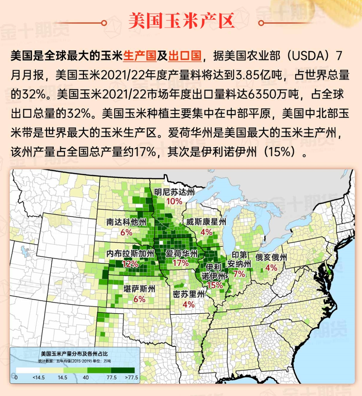
Corn Planting Area of the United States Showers and a few thunderstorms extend southwest from the Upper Midwest. At the same time, warm and mostly dry weather in the eastern corn belt is favorable for late-season corn and soybean planting, as well as winter wheat growth.
 Persistent drought further reduces surface soil moisture for winter wheat and cover crops to emerge and establish. Following the cold front, cooler air has diffused into the central plains, while the southern plains remain covered in record warmth. Today, much of southern Texas and Oklahoma will experience high temperatures of 90°F or higher. As of October 20, only 46% of winter wheat has emerged nationwide, lagging behind the 5-year average of 50%. Oklahoma's emergence rate is 32%, significantly below the 49% average.
Weather Outlook Initially, the active weather in most parts of the United States will eventually consolidate along the cold front sweeping through the central United States on Tuesday. Subsequently, the cold front will reach the coastal states along the Atlantic Ocean on Thursday, although cool and unstable showers will persist in the Great Lakes states for a few days. According to preliminary reports, the United States will breathe a sigh of relief from the continuous thunderstorms that triggered more than 500 tornadoes in May. Before calm weather arrives, precipitation in the eastern half of the United States may reach 1 to 3 inches, except in the southern hinterland. In addition, early heat waves will expand in the western United States this weekend, with maximum temperatures exceeding 110 degrees Fahrenheit and covering lower altitude areas in the desert southwest.
With the movement of a weak cold front, seasonally cool air follows, while the Ohio River Valley region continues to experience record warmth. The rainfall generated by the front is minimal, allowing harvesting activities to proceed at a rapid pace. Some areas in the Midwest that reported less than a tenth of an inch of rain in September—including Minneapolis-St. Paul, Minnesota, and Norfolk, Nebraska—have also received less than a tenth of an inch of rain from October 1 to 22. As of October 20, surface soil moisture across all Midwest states has been rated from more than half very short to short, with Nebraska leading at 86%.
Map of US Corn Production Areas
The very warm and dry weather is promoting outdoor activities, including the continued recovery work after Hurricanes Helen and Milton. Most harvesting activities are progressing rapidly, but in areas affected by drought, the lack of surface soil moisture and surface water is posing ongoing challenges for livestock producers as well as those planting winter grains and cover crops. In Louisiana, as of October 20th, 29% of sugarcane has been harvested, compared to a 5-year average of 21%.
Chicago SRW Wheat and Corn Futures
Over the next 5 days, a fast-moving cold front will provide a brief respite from the warm and dry pattern that has affected much of the country in recent weeks. Some of the most significant rainfall will occur in the central and western areas from Thursday to early Friday, and in the northwest over the weekend. Total amounts over the five days could reach half an inch in parts of the corn belt, while the Pacific Northwest could see 2 to 4 inches in total. Much of the country will continue to experience warm and dry weather, with negligible rainfall expected over the weekend in the plains and southern parts of the country.
The National Weather Service's 6 to 10 day outlook forecast from October 28th to November 1st indicates above-normal temperatures in the central and eastern United States, while the western part will experience below-normal conditions. At the same time, much of the country is expected to have near or above-normal precipitation, contrasting with the dry conditions in the central and northern Atlantic states and the adjacent Appalachian region.
Soybeans should be translated as soybean.

The Atlantic Ocean should be translated as the Atlantic.

Cotton should be translated as cotton.


 持续的干旱进一步降低了冬小麦和覆盖作物出苗和建立的表层土壤湿度。在冷锋过后,较凉爽的空气已经扩散到中部平原地区,但南部平原地区却覆盖着创纪录的温暖。今天,德克萨斯州和俄克拉荷马州南部的大部分地区高温将达到90°F或更高。截至10月20日,全国只有46%的冬小麦出苗,落后于5年平均的50%。俄克拉荷马州的出苗率为32%,显著落后于49%的平均值。