
 冷空气沿着从北达科他州的红河谷到内布拉斯加州西部的线到来。北达科他州有分散的阵雨,这些凉爽的天气带来了一些雨水。但在大多数大平原地区,持续的干旱限制了最近种植的冬小麦的水分供应,同时也有利于夏季作物的成熟和收获。
The 6-10 day outlook from October 23rd to 27th by the National Weather Service of the USA indicates that temperatures in most parts of the USA may be above normal levels.
The following is the exclusive compilation of agricultural weather tips on Friday, October 18, 2024 in the USA by Golden Ten Futures App.
Western United States Cool and rainy weather extends from the northwestern Pacific to the northern Rockies. This rain is beneficial for crops in the northwest, including winter wheat and small grains sown in the spring. At the same time, the hot weather in the Southwest is beneficial for farming and crop growth, although there is a high wildfire threat in some areas of Arizona and New Mexico.
The region has welcomed cool air, with only the central and southern Rocky Mountains retaining warmth. In central and southern California, dry weather and strong winds have significantly increased the risk of wildfires. However, some areas in the Four Corners states will see beneficial rainfall.
Corn Planting Area of the United States Showers and a few thunderstorms extend southwest from the Upper Midwest. At the same time, warm and mostly dry weather in the eastern corn belt is favorable for late-season corn and soybean planting, as well as winter wheat growth.
 Cold air is arriving along a line from the Red River Valley in North Dakota to western Nebraska. North Dakota has scattered showers, bringing some rain with the cooler weather. However, in most of the Great Plains, ongoing drought has limited the water supply for recently planted winter wheat, while benefiting the maturation and harvesting of summer crops.
Weather Outlook Initially, the active weather in most parts of the United States will eventually consolidate along the cold front sweeping through the central United States on Tuesday. Subsequently, the cold front will reach the coastal states along the Atlantic Ocean on Thursday, although cool and unstable showers will persist in the Great Lakes states for a few days. According to preliminary reports, the United States will breathe a sigh of relief from the continuous thunderstorms that triggered more than 500 tornadoes in May. Before calm weather arrives, precipitation in the eastern half of the United States may reach 1 to 3 inches, except in the southern hinterland. In addition, early heat waves will expand in the western United States this weekend, with maximum temperatures exceeding 110 degrees Fahrenheit and covering lower altitude areas in the desert southwest.
Due to the dry weather and gradually warming trend, harvesting activities for corn and soybeans are faster than normal. Although frost and freezing were observed in some areas of the eastern Corn Belt this morning, today's highs in the Midwest should generally range between 65 to 80°F, with the warmest weather affecting the central Missouri Valley. As of October 13, surface soil moisture in the Midwest ranged from very short in Michigan to short in Nebraska, ranging from 51% to 86%.
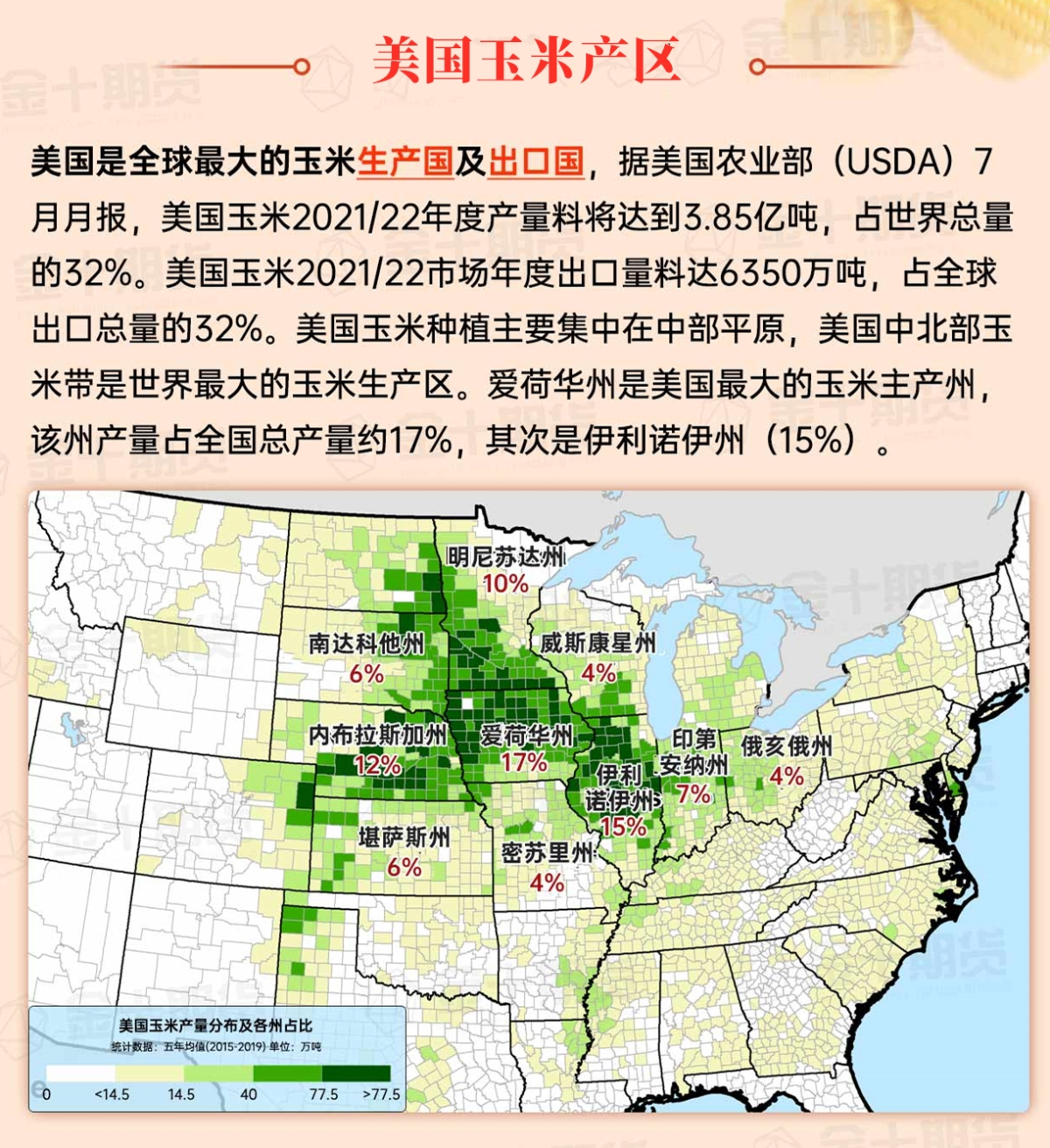
Map of US Corn Production Areas
Cool and dry weather is conducive to autumn field work, including the harvest of summer crops and the planting of winter wheat. This morning, widespread frosts and freezes were reported again in the southeastern inland areas, the Tennessee Valley, and states in the central Atlantic Ocean region. These freezes may hinder grass growth, but have little impact on most summer crops that are already mature or harvested.
Chicago SRW Wheat and Corn Futures
For at least the next 5 days, in the area from the Mississippi Valley to the Atlantic coast, the weather will be predominantly dry, accompanied by a rising trend in temperatures. Meanwhile, weather patterns in the western and central United States will become more active. Significant precipitation is expected in the northwestern Pacific region, the Four Corners states, and the central and southern parts of the High Plains. Some western regions, including California and the Great Basin, will remain mostly dry. Showers may briefly spread to the upper Midwest, but effective rainfall will be very scarce in the Corn Belt, southern, and eastern regions in the coming days. However, intermittent showers may affect southern Texas and the Florida Peninsula.
The 6 to 10-day outlook from the National Weather Service from October 23rd to 27th shows that temperatures in most parts of the United States may be higher than normal, with precipitation close to or below normal levels. Below-normal temperatures will be limited to only the northwestern Pacific, and wetter weather than normal should only be limited to southern Texas, northern California, and the northwestern Pacific.
Soybeans should be translated as soybean.
The Atlantic Ocean should be translated as the Atlantic.
Cotton should be translated as cotton.

