
 平原地区天气温暖干燥,有利于夏季作物的成熟和收获,以及冬小麦的种植和出苗。北部高原地区今天的最高气温可能达到95°F。尽管近期有雨水,但一些地区土壤湿度仍然不足。
The 6-10 day outlook from the American National Weather Service from September 30 to October 4 shows that the national temperatures will be near or above normal levels, with the southwestern region most likely to experience warm weather.
The following is the agricultural weather forecast for Wednesday, September 25, 2024 in the USA, exclusively compiled by GoldenTen Futures App.
Western United States Cool and rainy weather extends from the northwestern Pacific to the northern Rockies. This rain is beneficial for crops in the northwest, including winter wheat and small grains sown in the spring. At the same time, the hot weather in the Southwest is beneficial for farming and crop growth, although there is a high wildfire threat in some areas of Arizona and New Mexico.
The weather in the western region is sunny with temperatures higher than normal. Inland areas of northwestern Canada are particularly warm, accompanied by strong winds, and some areas have already issued dust warnings. The highest temperatures in these areas today may reach 90°F. This high temperature and dry weather are beneficial for crop ripening and harvesting, but in some areas, the emergence of autumn-sown grains is still a concern due to insufficient topsoil moisture.
Corn Planting Area of the United States Showers and a few thunderstorms extend southwest from the Upper Midwest. At the same time, warm and mostly dry weather in the eastern corn belt is favorable for late-season corn and soybean planting, as well as winter wheat growth.
 The plains region is warm and dry, which is conducive to the maturity and harvesting of summer crops, as well as the planting and emergence of winter wheat. The highest temperature in the northern plateau region today may reach 95°F. Despite recent rainfall, soil moisture in some areas is still insufficient.
Weather Outlook Initially, the active weather in most parts of the United States will eventually consolidate along the cold front sweeping through the central United States on Tuesday. Subsequently, the cold front will reach the coastal states along the Atlantic Ocean on Thursday, although cool and unstable showers will persist in the Great Lakes states for a few days. According to preliminary reports, the United States will breathe a sigh of relief from the continuous thunderstorms that triggered more than 500 tornadoes in May. Before calm weather arrives, precipitation in the eastern half of the United States may reach 1 to 3 inches, except in the southern hinterland. In addition, early heat waves will expand in the western United States this weekend, with maximum temperatures exceeding 110 degrees Fahrenheit and covering lower altitude areas in the desert southwest.
In the corn belt region, scattered showers are limited to the Ohio River Valley and downstream areas of the Great Lakes. Weather in other regions of the Midwest USA is warm and dry, favorable for field operations, including early harvesting activities. However, in areas such as Missouri and southern Illinois where recent rainfall has been significant, field operations remain suspended.
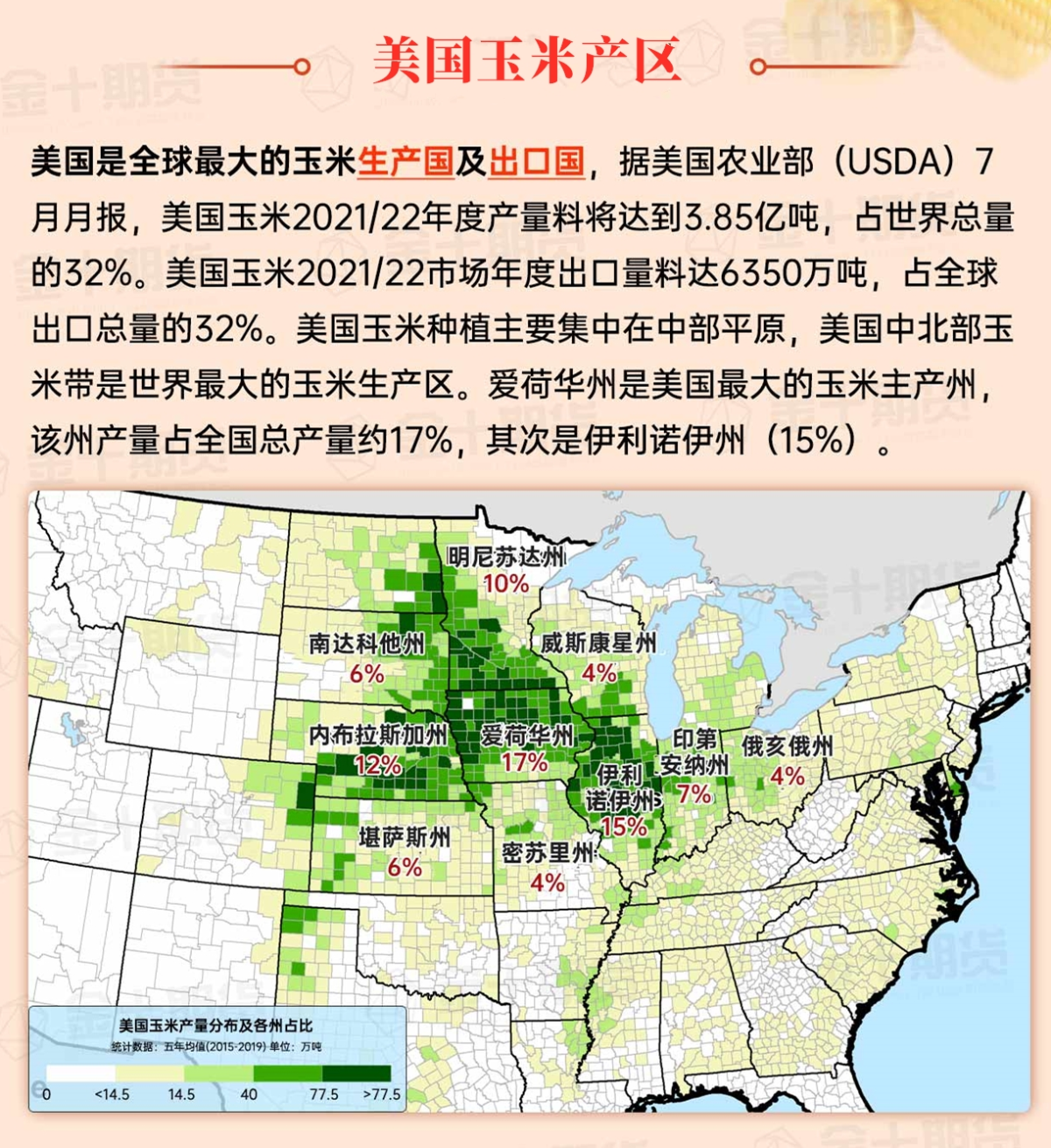
Map of US Corn Production Areas
In parts of Florida, Georgia, and neighboring states, as Tropical Storm Helen approaches, producers are making final preparations. Cotton in the southeastern region has already opened, and peanut harvest has just begun, making these areas very sensitive to the upcoming heavy rain and strong winds.
Chicago SRW Wheat and Corn Futures
Tropical Storm Helen is expected to soon intensify into a hurricane and make landfall in the Big Bend area of Florida on Thursday night, with a strength and path similar to the Category 3 Hurricane Ida on August 30, 2023. Less than two months ago, the Category 1 Hurricane Dabby also made landfall in the same area of Florida. It is expected that Helen will bring a storm surge of 10 to 15 feet to the center of landfall and its east side, with at least 5 feet of storm surge on the west coast of Florida. In addition, hurricane-force winds may affect central-northern and southwestern Florida, impacting crops such as timber, cotton, and pecans. Finally, total rainfall in the southeastern region is expected to reach 5 to 10 inches, with localized areas possibly higher, potentially leading to serious inland flooding that could extend as far as the southern Appalachian Mountains. With Helen's remnants interacting with disturbances in the central and southern regions, rainfall in the southeast may persist for several days. Apart from the southeast, most of the United States will experience warm and dry weather, favorable for the maturation and harvesting of summer crops, as well as the planting of winter wheat. However, in areas affected by drought, insufficient soil moisture for winter grains and cover crops remains a concern.
The National Weather Service's 6-10 day outlook from September 30 to October 4 shows that national temperatures will be near or above normal levels, with the southwestern region most likely to experience warm weather. At the same time, precipitation levels in most of the country will be near or below normal, contrasting with the wetter weather in the southern and Atlantic central states.
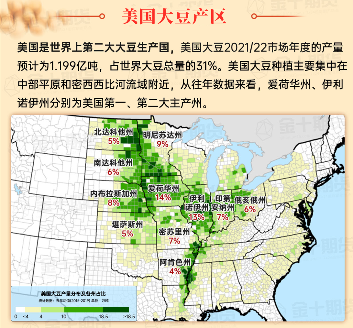
Soybeans should be translated as soybean.
The Atlantic Ocean should be translated as the Atlantic.
Cotton should be translated as cotton.

