
 在近期的降雨之后,大部分地区天气转干。周末的降雨主要在堪萨斯州,扩展到俄克拉荷马州西北部和德克萨斯州北部狭长地带,对最近种植的冬小麦总体上是有益的,尽管一些地区出现了短暂的田间作业中断。今天早些时候,残留的阵雨从堪萨斯州东南部延伸到德克萨斯州中部。
The 6-10 day outlook from September 28th to October 2nd by the National Weather Service of the usa shows that most parts of the country will have warmer weather than normal, while temperatures in the northwest Pacific region will be close to or below normal levels.
The following is the agricultural weather forecast for the United States on Monday, September 23, 2024, exclusively compiled by Golden Ten Futures App.
Western United States Cool and rainy weather extends from the northwestern Pacific to the northern Rockies. This rain is beneficial for crops in the northwest, including winter wheat and small grains sown in the spring. At the same time, the hot weather in the Southwest is beneficial for farming and crop growth, although there is a high wildfire threat in some areas of Arizona and New Mexico.
The weather is warm and dry, conducive to field operations, including the harvest of summer crops and the planting of winter wheat in northwestern Canada. Today, the highest temperature in California's Central Valley will exceed 100°F, and rice harvesting here was already 15% completed on September 15.
Corn Planting Area of the United States Showers and a few thunderstorms extend southwest from the Upper Midwest. At the same time, warm and mostly dry weather in the eastern corn belt is favorable for late-season corn and soybean planting, as well as winter wheat growth.
 After recent rainfall, most areas have turned dry. Weekend rains were mainly in Kansas, extending to the northwestern regions of Oklahoma and a narrow strip of northern Texas. Overall, it was beneficial for the recently planted winter wheat, although some areas experienced brief interruptions in field operations. Earlier today, residual showers extended from southeastern Kansas to central Texas.
Weather Outlook Initially, the active weather in most parts of the United States will eventually consolidate along the cold front sweeping through the central United States on Tuesday. Subsequently, the cold front will reach the coastal states along the Atlantic Ocean on Thursday, although cool and unstable showers will persist in the Great Lakes states for a few days. According to preliminary reports, the United States will breathe a sigh of relief from the continuous thunderstorms that triggered more than 500 tornadoes in May. Before calm weather arrives, precipitation in the eastern half of the United States may reach 1 to 3 inches, except in the southern hinterland. In addition, early heat waves will expand in the western United States this weekend, with maximum temperatures exceeding 110 degrees Fahrenheit and covering lower altitude areas in the desert southwest.
This morning, the upper Great Lakes region issued frost warnings, mainly affecting the northern parts of Wisconsin and the northeastern part of Minnesota. The weather in the major corn and soybean production areas in the Midwest has turned cooler, but there has been no frost. This morning, the showers in the eastern corn belt have ended; however, a new round of localized heavy rain has covered the mid-Mississippi and lower Ohio River valleys, causing some delays in field operations.
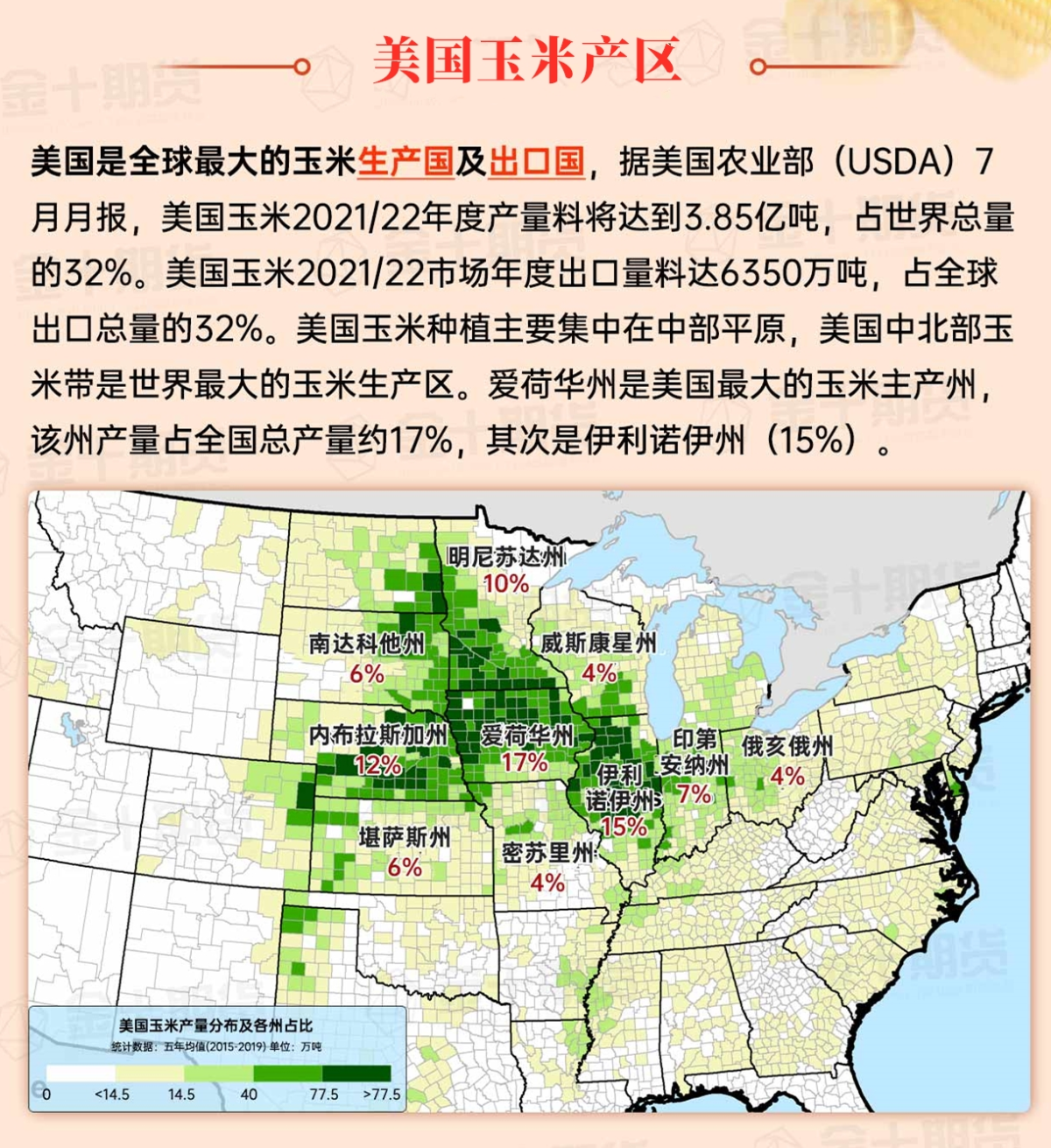
Map of US Corn Production Areas
The hot weather continues from the western Gulf of Mexico coastal areas to the southern Atlantic coastal areas, all the way to the Tennessee Valley. Meanwhile, as a cold front approaches, showers have appeared in the central and southern regions, including parts of Arkansas. With the southeastern region preparing for possible tropical activity later this week, producers are harvesting summer crops such as corn, cotton, peanuts, and soybeans as much as possible.
Chicago SRW Wheat and Corn Futures
Over the next few days, a tropical cyclone is expected to develop in the northwestern Caribbean Sea. Due to the system's expected northward movement, residents in the eastern coastal areas of the Gulf of Mexico in the United States need to monitor its progress. At the same time, the cold front currently moving southeast from the Great Lakes downstream to Texas will help concentrate showers and thunderstorm activity. Rainfall near the front could reach 1 to 3 inches, with some localized areas possibly higher. Some of the heaviest rainfall may occur in the dry central Appalachian Mountains and Ohio River Valley regions. In contrast, from western Texas to north and northwest of Lake Superior, most weather will remain dry over the next 5 days, except for precipitation in the Pacific Northwest later in the weekend. With a general warming trend in the western and central United States, temperatures later this week will rise to 90°F or even higher, extending to the northern plateau regions.
The 6 to 10 day outlook from the National Weather Service from September 28 to October 2 shows that most of the country will experience warmer temperatures than normal, with temperatures in the Pacific Northwest approaching or falling below normal levels. At the same time, most areas of the country will have near or below normal precipitation levels. Compared to the southeastern region, which will have wetter than normal conditions, extending to parts of the Ohio River Valley and the central and eastern Corn Belt.
Soybeans should be translated as soybean.
The Atlantic Ocean should be translated as the Atlantic.
Cotton should be translated as cotton.

