
 晚季热浪盛行于该地区的东南部,今天的最高温度预计在90至100°F之间。相比之下,蒙大拿州最近的降雨缓解了当地的干旱情况,零星的雷暴扩展到北部平原和高平原的其他地区。尽管如此,由于冬小麦种植和建立季节的进行,平原地区仍将受益于额外的降雨。
The 6-10 day outlook from the National Weather Service in the USA from September 24th to 28th shows that temperatures across the country will be near or above normal levels. The western, northern, and southern regions of Texas are most likely to experience warmer weather than usual.
Below is the agricultural weather forecast for USA on Thursday, September 19, 2024, exclusively compiled by Gold Futures App.
Western United States Cool and rainy weather extends from the northwestern Pacific to the northern Rockies. This rain is beneficial for crops in the northwest, including winter wheat and small grains sown in the spring. At the same time, the hot weather in the Southwest is beneficial for farming and crop growth, although there is a high wildfire threat in some areas of Arizona and New Mexico.
Mostly dry weather is favorable for field work. Earlier today, precipitation was limited to certain areas in central California. In Arizona, as of September 15, cotton harvesting has been completed by 17%, exceeding the 5-year average of 9%. On the same date, rice harvesting in California was completed by 15%, surpassing the average of 7%. Elsewhere, winter wheat planting in the Northwest has been completed by 11% in Idaho and 43% in Washington State.
Corn Planting Area of the United States Showers and a few thunderstorms extend southwest from the Upper Midwest. At the same time, warm and mostly dry weather in the eastern corn belt is favorable for late-season corn and soybean planting, as well as winter wheat growth.
 A late-season heatwave prevails in the southeastern part of the region, with today's highest temperature expected to be between 90 and 100°F. In contrast, recent rainfall in Montana has relieved local drought conditions. Isolated thunderstorms have extended to other areas of the Northern Plains and High Plains. However, the prairie region will still benefit from additional rainfall due to winter wheat planting and establishment season.
Weather Outlook Initially, the active weather in most parts of the United States will eventually consolidate along the cold front sweeping through the central United States on Tuesday. Subsequently, the cold front will reach the coastal states along the Atlantic Ocean on Thursday, although cool and unstable showers will persist in the Great Lakes states for a few days. According to preliminary reports, the United States will breathe a sigh of relief from the continuous thunderstorms that triggered more than 500 tornadoes in May. Before calm weather arrives, precipitation in the eastern half of the United States may reach 1 to 3 inches, except in the southern hinterland. In addition, early heat waves will expand in the western United States this weekend, with maximum temperatures exceeding 110 degrees Fahrenheit and covering lower altitude areas in the desert southwest.
Showers extend southward from Minnesota, with the rain only causing minor delays to field work and minimal impact on the prevalent drought in the central and western regions. The entire central and western regions are generally warm, with today's highest temperature expected to be between 80 and 90°F, possibly higher in the Corn Belt in the southwest.
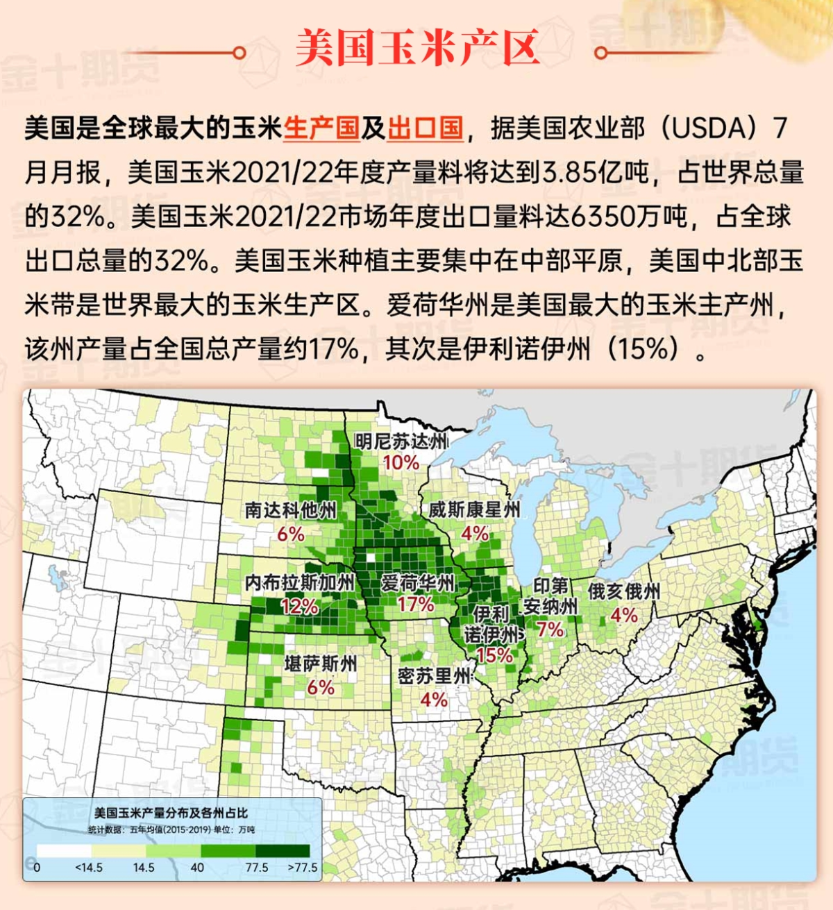
Map of US Corn Production Areas
Some showers persist along the Atlantic coast. Warm, dry weather covers the rest of the southern region. Following recent rainfall from Hurricane Francis and Potential Tropical Cyclone Eight, the southern region presents a peculiar mix of wet and dry conditions, with ongoing agricultural drought impact including poor pasture conditions and low pond levels.
Chicago SRW Wheat and Corn Futures
This weekend, active weather in the central USA is expected to peak in intensity. Significant precipitation (typically 1 to 3 inches) is forecasted from the central Rockies and Plains to the Midwest. While the precipitation will slow field operations, including harvesting activities, the benefits should include potential increases in river levels and improvements in surface soil moisture for pastures and winter grains. However, over the next 5 days, much of the southern and western USA will experience dry weather. Unusual warmth will accompany the dryness in the south, and temperatures in California and the Southwest desert will rise above normal levels. In the Atlantic Basin, there is a possibility of tropical cyclone development in the western Caribbean Sea early next week, which could affect the USA if the future system enters the Gulf of Mexico.
The 6-10 day outlook from the National Weather Service from September 24th to 28th shows that national temperatures in the USA will be near or above normal levels, with the western, northern, and southern parts of Texas most likely to experience warmer than usual weather. Meanwhile, precipitation in the western and north-central USA, as well as the northern New England, is expected to be near or below normal levels. This contrasts with wetter than normal conditions from the Midwest and Southern Plains to the Atlantic Coast, extending as far as the Ohio River Valley and southern New England.
Soybeans should be translated as soybean.
The Atlantic Ocean should be translated as the Atlantic.
Cotton should be translated as cotton.

