
 蒙大拿州和达科他州的部分地区出现了阵雨天气,这减缓了大麦和春小麦的最终收获工作。在平原的其他地区,温暖干燥的天气有利于夏季作物的成熟和收获,尽管对于新种植的冬小麦的发芽和适当生长,土壤湿度普遍不足。
The 6-10 day outlook from the National Weather Service in the USA for September 18th to September 22nd shows precipitation levels near or above normal in most areas of the country.
The following is the agriculture weather report for the United States on Friday, September 13, 2024, exclusively compiled by GoldenTen Futures APP.
Western United States Cool and rainy weather extends from the northwestern Pacific to the northern Rockies. This rain is beneficial for crops in the northwest, including winter wheat and small grains sown in the spring. At the same time, the hot weather in the Southwest is beneficial for farming and crop growth, although there is a high wildfire threat in some areas of Arizona and New Mexico.
Cool air continues to replace the previous high-temperature conditions. Any remaining heat is usually limited to the Southern Rocky Mountains and the southwestern desert areas. This morning, there is frost warning in some areas of central and southern Oregon, while high-altitude areas in the northern Rocky Mountains still have snow accumulation.
Corn Planting Area of the United States Showers and a few thunderstorms extend southwest from the Upper Midwest. At the same time, warm and mostly dry weather in the eastern corn belt is favorable for late-season corn and soybean planting, as well as winter wheat growth.
 Some areas of Montana and the Dakotas are experiencing showers, which have slowed down the final harvest of barley and spring wheat. In other areas of the plains, warm, dry weather is beneficial for the ripening and harvesting of summer crops, although soil moisture is generally insufficient for the germination and proper growth of newly planted winter wheat.
Weather Outlook Initially, the active weather in most parts of the United States will eventually consolidate along the cold front sweeping through the central United States on Tuesday. Subsequently, the cold front will reach the coastal states along the Atlantic Ocean on Thursday, although cool and unstable showers will persist in the Great Lakes states for a few days. According to preliminary reports, the United States will breathe a sigh of relief from the continuous thunderstorms that triggered more than 500 tornadoes in May. Before calm weather arrives, precipitation in the eastern half of the United States may reach 1 to 3 inches, except in the southern hinterland. In addition, early heat waves will expand in the western United States this weekend, with maximum temperatures exceeding 110 degrees Fahrenheit and covering lower altitude areas in the desert southwest.
Rainfall associated with the post-tropical cyclone Francis has spread to the southern and eastern areas of Missouri, the southern areas of Illinois, and the southern areas of Indiana. In the remaining areas of the Midwest, warm, dry weather is favorable for the ripening of corn and soybeans. The dry conditions have also promoted fieldwork, including the early planting of winter wheat.
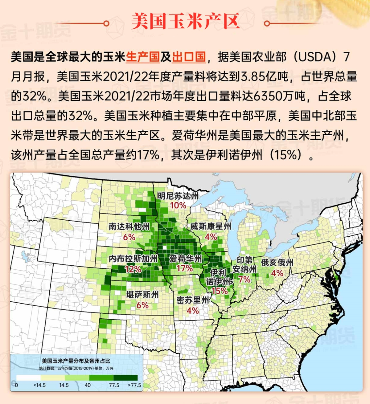
Map of US Corn Production Areas
The post-tropical residual circulation of Hurricane Frances is almost stationary, with its center located in northern Arkansas. Showers associated with Frances have become more scattered, but localized heavy rainfall is still occurring from the northern Mississippi Delta to the Atlantic coastal states, extending northward to the Tennessee Valley and Carolina. After the impact of Frances, over 0.1 million users in Louisiana still do not have electrical utilities.
Chicago SRW Wheat and Corn Futures
It is expected that the remnants of Frances will dissipate in the central and southern parts later today or on Saturday, although additional rainfall of 3 to 6 inches or more is still possible in northern and central Alabama and surrounding areas. At the same time, a low-pressure system is expected to form near the South Atlantic coast and could acquire subtropical or tropical characteristics before crossing inland through Carolina in the early part of next week. Regardless of development, localized heavy rainfall may occur in parts of the southern and central Atlantic states in the first half of next week. Meanwhile, the western storm system expected to arrive later this weekend could bring moisture associated with Tropical Storm Elana in the eastern Pacific, resulting in increased rainfall activity. By early next week, the rainfall may spread to the Plains region. In contrast, most of the time in the next 5 days, dry weather will prevail from the Great Lakes region to New England.
The 6-10 day outlook from the National Weather Service from September 18th to 22nd shows that temperatures in most areas east of the Plains may be above normal, while the western region will experience below normal conditions. At the same time, precipitation in most parts of the country is near or above normal, in contrast to the dry weather in the western Gulf Coast, parts of the Southwest, and the dry weather from the eastern Corn Belt to New England.
Soybeans should be translated as soybean.
The Atlantic Ocean should be translated as the Atlantic.
Cotton should be translated as cotton.

