
 大部分时间天气干燥,这对田间作业和夏季作物成熟非常有利。但是,由于土壤湿度普遍不足,农民开始种植冬小麦时可能会遇到问题。此外,西部的温暖气候开始向北部高原地区扩散,今天蒙大拿州部分地区的高温将接近90°F。
The 6-10 day outlook from the United States National Weather Service from September 11th to September 15th shows that temperatures in most areas of the United States will be close to or above normal levels.
The following is the exclusive compilation of the agricultural weather tips for Friday, September 6, 2024 in the United States by Jinshi Futures App.
Western United States Cool and rainy weather extends from the northwestern Pacific to the northern Rockies. This rain is beneficial for crops in the northwest, including winter wheat and small grains sown in the spring. At the same time, the hot weather in the Southwest is beneficial for farming and crop growth, although there is a high wildfire threat in some areas of Arizona and New Mexico.
Dry weather accompanied by seasonal high temperatures, today's maximum temperature could reach 100°F or even higher, extending all the way to the eastern part of Washington State, with temperatures in the southwest desert region expected to exceed 110°F. Due to soil moisture exceeding 60% in the northwest on September 1, it was rated as very short to short, and people are concerned about the increased threat of wildfires and unfavorable dry weather for germination and establishment of newly planted winter wheat.
Corn Planting Area of the United States Showers and a few thunderstorms extend southwest from the Upper Midwest. At the same time, warm and mostly dry weather in the eastern corn belt is favorable for late-season corn and soybean planting, as well as winter wheat growth.
 Most of the time the weather is dry, which is very beneficial for field operations and the ripening of summer crops. However, due to generally inadequate soil moisture, farmers may encounter problems when planting winter wheat. In addition, the warm climate in the west is spreading to the northern plateau area, and today's high temperatures in parts of Montana will approach 90°F.
Weather Outlook Initially, the active weather in most parts of the United States will eventually consolidate along the cold front sweeping through the central United States on Tuesday. Subsequently, the cold front will reach the coastal states along the Atlantic Ocean on Thursday, although cool and unstable showers will persist in the Great Lakes states for a few days. According to preliminary reports, the United States will breathe a sigh of relief from the continuous thunderstorms that triggered more than 500 tornadoes in May. Before calm weather arrives, precipitation in the eastern half of the United States may reach 1 to 3 inches, except in the southern hinterland. In addition, early heat waves will expand in the western United States this weekend, with maximum temperatures exceeding 110 degrees Fahrenheit and covering lower altitude areas in the desert southwest.
The cold front extending from the southern Great Lakes region to the central Mississippi Valley brought only a small amount of showers. However, this cold front separates the late-season warmth in the Ohio Valley from the unusually cool temperatures in the Great Lakes region. Due to the fact that most of the high temperatures in Minnesota, Wisconsin, and Michigan are not expected to exceed 70°F today, crop growth in the northern corn belt has slowed down.
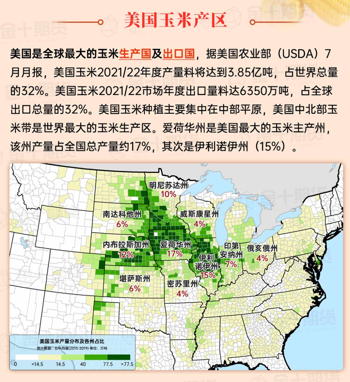
Map of US Corn Production Areas
From the Mississippi Delta to the South Atlantic coast, the weather is unstable with frequent showers. The humid weather has slowed down field work, including the harvesting of corn and rough rice. In other areas, dry weather covers the coastal areas of Texas, while the dry weather aids in the maturation of summer crops and early harvesting from the Tennessee Valley to the mid-Atlantic states.
Chicago SRW Wheat and Corn Futures
Cool air in the central and western regions will continue throughout the weekend, with temperatures rising rapidly afterward. Frost may occur over the weekend due to the cool air in the Great Lakes region, including northern Minnesota and northern Wisconsin. Next week, the rest of the United States will experience temperatures close to or above normal levels, with the hottest weather occurring in the western United States. Meanwhile, over the next 5 days, precipitation will be very scarce from the Pacific coast to the middle and upper Mississippi Valley. However, in the southern regions, rainy weather will persist along the Gulf of Mexico coast and the South Atlantic states, with partial heavy rain returning to coastal Texas at the beginning of next week. Over the next five days, rainfall in parts of the Gulf Coast and Florida could reach 5 inches or more.
The 6-10 day outlook from the National Weather Service from September 11th to September 15th shows that temperatures in most parts of the United States will be near or above normal levels, with precipitation near or below normal levels. Areas with temperatures below normal will be limited to the deep southern regions, excluding South Florida, while more humid weather than normal will be limited to two areas: from the northwest Pacific to the northern Plains, and from southern Texas to the South Atlantic coast.
Soybeans should be translated as soybean.
The Atlantic Ocean should be translated as the Atlantic.
Cotton should be translated as cotton.

