
The 6 to 10 day outlook from the National Weather Service in the USA from September 10 to September 14 shows that temperatures in most parts of the USA are near or above normal levels.
The following is the agricultural weather forecast for Thursday, September 5, 2024 in the USA, exclusively compiled by the Jinshi Futures app.
Western United States Cool and rainy weather extends from the northwestern Pacific to the northern Rockies. This rain is beneficial for crops in the northwest, including winter wheat and small grains sown in the spring. At the same time, the hot weather in the Southwest is beneficial for farming and crop growth, although there is a high wildfire threat in some areas of Arizona and New Mexico.
There is limited rainfall in the central Rocky Mountains. The rest of the western USA will experience hot and dry weather, with the highest temperature expected to exceed 115°F in the desert areas of the southwest today. Temperatures close to 100°F will extend to some areas in the northwest, where large wildfires have reduced visibility and air quality.
Corn Planting Area of the United States Showers and a few thunderstorms extend southwest from the Upper Midwest. At the same time, warm and mostly dry weather in the eastern corn belt is favorable for late-season corn and soybean planting, as well as winter wheat growth.
Cooler air covers Dakota and its surrounding areas, while warm and mostly dry weather in the central USA is conducive to the maturation and harvest of summer crops. However, as producers begin to plant winter wheat, some areas are experiencing inadequate soil moisture. The USDA and the National Agricultural Statistics Service (NASS) reported on September 1 that the topsoil moisture in Texas (79%), Montana (77%), Colorado (65%), and Kansas (51%) is rated as extremely to very short.
Weather Outlook Initially, the active weather in most parts of the United States will eventually consolidate along the cold front sweeping through the central United States on Tuesday. Subsequently, the cold front will reach the coastal states along the Atlantic Ocean on Thursday, although cool and unstable showers will persist in the Great Lakes states for a few days. According to preliminary reports, the United States will breathe a sigh of relief from the continuous thunderstorms that triggered more than 500 tornadoes in May. Before calm weather arrives, precipitation in the eastern half of the United States may reach 1 to 3 inches, except in the southern hinterland. In addition, early heat waves will expand in the western United States this weekend, with maximum temperatures exceeding 110 degrees Fahrenheit and covering lower altitude areas in the desert southwest.
With a cold front approaching, the southeastern region is generally warm, and the highest temperature in the Mid-Mississippi River Valley is expected to exceed 90°F. This warmth is accelerating the maturation of corn and soybeans, but putting pressure on immature crops. Meanwhile, cooler air covers the corn belt in the northwest, with rainfall mainly occurring in the upper Great Lakes region.
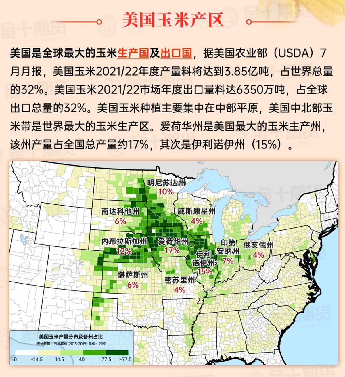
Map of US Corn Production Areas
A low-pressure system is forming over the northwest part of the Gulf of Mexico, bringing localized heavy rain. The areas with the heaviest rainfall are along the central Gulf of Mexico coast and the upper coast of Texas. The rain also extends eastward along the South Atlantic coast. In the rest of the southern United States, warm and dry weather is promoting the maturation and harvest of summer crops.
Chicago SRW Wheat and Corn Futures
Currently, a cold front extending from the Great Lakes states southwestward will push eastward over the weekend, reaching the Atlantic coast. The cold front may bring brief heavy rain to parts of the Great Lakes and northeastern states. The cool air behind the cold front will result in temperatures below 50°F in the Midwest and Western regions over the weekend. There may be scattered frost in the upstream areas of the Great Lakes, which are not major corn and soybean production areas. Meanwhile, the deep southern region will continue to be humid, with a 5-day rainfall total of 2 to 6 inches or more from the coastal areas of Texas to the South Atlantic coast. However, any rainfall will sharply decrease in the northern areas, and dry weather is expected from the Mississippi Delta to the Mid-Atlantic states. Additionally, most of the western United States will experience hot and dry weather, with record-breaking high temperatures expected in the northern plateau and inland Northwest this weekend.
The 6 to 10-day outlook from the National Weather Service from September 10th to September 14th shows that temperatures in most parts of the United States will be near or above normal, with a higher possibility of rainfall near or below normal levels. The temperatures in the southern United States, except for the Florida peninsula, will be below normal, while there will be above-normal rainfall in northern California, the Pacific Northwest, and the areas from the coastal areas of Texas to the South Atlantic coast.
Soybeans should be translated as soybean.
The Atlantic Ocean should be translated as the Atlantic.
Cotton should be translated as cotton.
