
The 6-10 day outlook from the National Weather Service in the USA shows that temperatures in the Florida Peninsula and along the Pacific coast to the plains and upper Midwest are near or above normal levels.
The following is the agricultural weather forecast for Friday, September 3, 2024 in the USA, compiled exclusively by Atlantic China Welding Consumables, Inc.
Western United States Cool and rainy weather extends from the northwestern Pacific to the northern Rockies. This rain is beneficial for crops in the northwest, including winter wheat and small grains sown in the spring. At the same time, the hot weather in the Southwest is beneficial for farming and crop growth, although there is a high wildfire threat in some areas of Arizona and New Mexico.
A cold front is approaching the Northern Rockies, causing some showers. Elsewhere, it is very warm and dry, favorable for field operations and the maturity of summer crops. Today's high temperature will reach 100°F, extending to the Sacramento Valley in California. However, due to strong winds, dry conditions, and low humidity, there is a high wildfire risk in parts of the Northern Basin and western Northern Nevada.
Corn Planting Area of the United States Showers and a few thunderstorms extend southwest from the Upper Midwest. At the same time, warm and mostly dry weather in the eastern corn belt is favorable for late-season corn and soybean planting, as well as winter wheat growth.
Rainfall in parts of Texas has been gradually alleviating the recent hot and dry weather. At the same time, unusually hot weather in the northwest of the plains has accelerated the maturity of spring wheat and barley crops. Today's high temperature may reach 100°F, extending to the western part of South Dakota.
Weather Outlook Initially, the active weather in most parts of the United States will eventually consolidate along the cold front sweeping through the central United States on Tuesday. Subsequently, the cold front will reach the coastal states along the Atlantic Ocean on Thursday, although cool and unstable showers will persist in the Great Lakes states for a few days. According to preliminary reports, the United States will breathe a sigh of relief from the continuous thunderstorms that triggered more than 500 tornadoes in May. Before calm weather arrives, precipitation in the eastern half of the United States may reach 1 to 3 inches, except in the southern hinterland. In addition, early heat waves will expand in the western United States this weekend, with maximum temperatures exceeding 110 degrees Fahrenheit and covering lower altitude areas in the desert southwest.
Dry weather accompanies temperatures that are approaching or below normal levels. Immature corn and soybeans have benefited from last week's rainfall, with the heaviest rainfall in the central and western Midwest (locally 1 to 3 inches or more). Recent rainfall has been lighter in the drought-affected eastern corn belt, where most crops are maturing faster than normal.
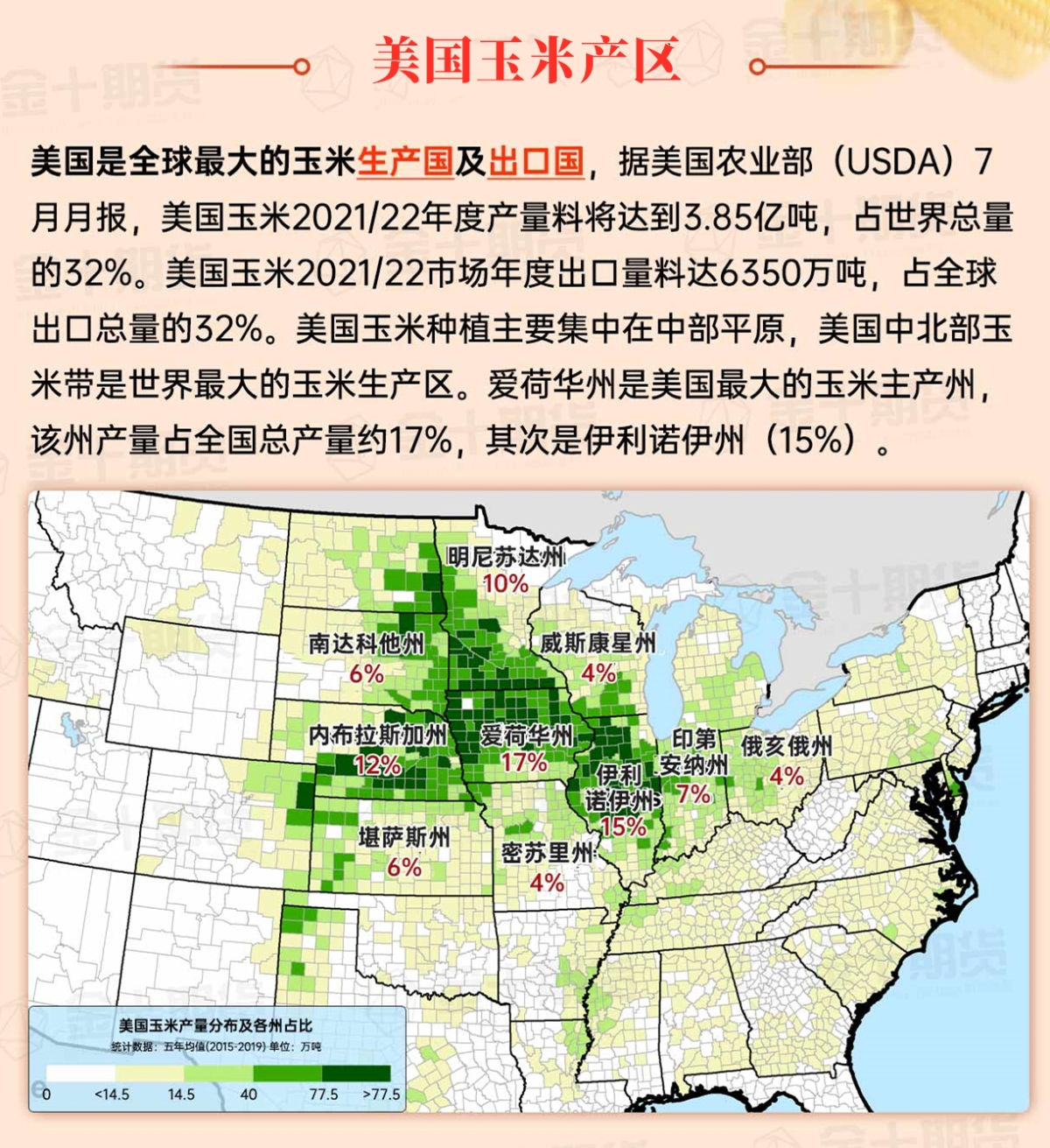
Map of US Corn Production Areas
Unstable and stormy weather continues to restrict field operations in the western Gulf of Mexico. Showers also affect field activities in parts of the Florida peninsula. Elsewhere, dry weather is favorable for the maturity and harvest of summer crops. Along the Atlantic coast states, relatively cool weather has extended to North Carolina.
Chicago SRW Wheat and Corn Futures
For most of this week, significant rainfall will be concentrated in the deep southern regions, from parts of Texas to the South Atlantic coast. However, in the middle to late part of this week, showers and thunderstorms are expected to sweep through the central regions to the east. Five-day rainfall totals from coastal Texas to Florida and southern Georgia may reach 2 to 4 inches or more. Meanwhile, in certain areas of the Great Lakes region, rainfall may reach 1 to 2 inches. In contrast, much of the Pacific coast to the plains and upper Mississippi Valley will have little to no precipitation. Late-season heat associated with dry conditions is expected to reach as far as the Pacific Northwest with temperatures reaching 100°F later this week. A strong cold front will reach the central and western regions, with high temperatures on Saturday expected to be between 60 and 75°F.
The 6 to 10-day outlook from the National Weather Service for September 8th to September 12th shows temperatures near or above normal levels for the Florida Peninsula and from the Pacific coast to the plains and upper Midwest, while temperatures will be below normal levels for the southern, eastern, and lower Midwest regions. Meanwhile, rainfall in much of the country will be near or below normal levels, with wetter conditions in New England, the Pacific Northwest, and the region from southern Texas to the South Atlantic coast.
Soybeans should be translated as soybean.
The Atlantic Ocean should be translated as the Atlantic.
Cotton should be translated as cotton.
