
 在经历了一段长时间的炎热干燥天气后,俄克拉荷马州和北德克萨斯州部分地区的天气正在转凉,湿度增加,这对受到显著压力的牧场、草场和未成熟的夏季作物是有利的。截至8月25日,德克萨斯州超过一半(58%)的牧场和草场状况被评为非常差至差,这一比例仅在三周前为36%。与此同时,在北部大平原地区,温暖干燥的天气有利于谷物的收获。
The 6-10 day outlook from the National Weather Service in the USA shows that there may be above-normal temperatures in the Gulf of Mexico coast and areas west of a line from southern New Mexico to Lake Superior.
The following is the agricultural weather forecast for Friday, August 30, 2024 in the USA, compiled exclusively by Jin10 Futures App.
Western United States Cool and rainy weather extends from the northwestern Pacific to the northern Rockies. This rain is beneficial for crops in the northwest, including winter wheat and small grains sown in the spring. At the same time, the hot weather in the Southwest is beneficial for farming and crop growth, although there is a high wildfire threat in some areas of Arizona and New Mexico.
Dry weather and above-normal temperatures are favorable for the maturity and harvest of summer crops. The temperature in the Sacramento Valley in California has reached triple digits (100 degrees Fahrenheit), while the highest temperature in the southwest desert region today will exceed 110 degrees Fahrenheit. In Arizona, as of August 25, 71% of cotton bolls have opened, surpassing the five-year average of 58%.
Corn Planting Area of the United States Showers and a few thunderstorms extend southwest from the Upper Midwest. At the same time, warm and mostly dry weather in the eastern corn belt is favorable for late-season corn and soybean planting, as well as winter wheat growth.
 After a prolonged period of hot and dry weather, the weather is cooling down and humidity is increasing in parts of Oklahoma and northern Texas, which is beneficial for stressed ranches, pastures, and immature summer crops. As of August 25, more than half (58%) of ranches and pastures in Texas were rated as very poor to poor, compared to 36% just three weeks ago. Meanwhile, in the northern Great Plains region, warm and dry weather is favorable for grain harvesting.
Weather Outlook Initially, the active weather in most parts of the United States will eventually consolidate along the cold front sweeping through the central United States on Tuesday. Subsequently, the cold front will reach the coastal states along the Atlantic Ocean on Thursday, although cool and unstable showers will persist in the Great Lakes states for a few days. According to preliminary reports, the United States will breathe a sigh of relief from the continuous thunderstorms that triggered more than 500 tornadoes in May. Before calm weather arrives, precipitation in the eastern half of the United States may reach 1 to 3 inches, except in the southern hinterland. In addition, early heat waves will expand in the western United States this weekend, with maximum temperatures exceeding 110 degrees Fahrenheit and covering lower altitude areas in the desert southwest.
There are showers near the cold front from Michigan to Missouri, providing beneficial moisture for summer crops that have experienced drier-than-normal weather in recent weeks. In the Ohio River Valley, the temperature today is generally above 95 degrees Fahrenheit.
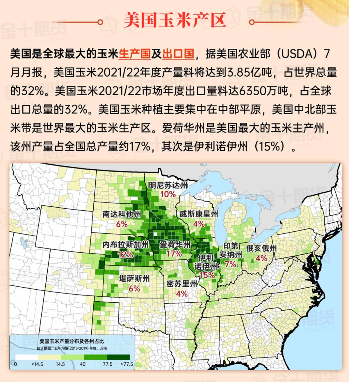
Map of US Corn Production Areas
Localized heavy rain continues to occur in the Gulf of Mexico coastal area, especially in southern Louisiana. Hot and humid weather covers most of the area, and thunderstorms are expected to become more frequent as the day progresses.
Chicago SRW Wheat and Corn Futures
In the next few days, a cold front crossing the central and northeastern parts will bring heavy rain and localized severe thunderstorms. The tail of the cold front will stall in the southern and central United States, causing an increase in rainfall, especially in the southern plains and the western Gulf of Mexico coastal area. Over the next five days, rainfall in parts of Texas could reach 2 to 4 inches or more, and rainfall in coastal areas of Texas and Louisiana could be even higher. In the rest of the southern United States, as well as the eastern and central parts of the Midwest, total rainfall may be 1 to 3 inches. After the cold front passes, cool and dry air will cover the lower central and midwestern regions on Saturday and the northeastern region on Sunday. At the same time, most of the time over the next five days will remain dry from the Pacific coast to the northern and central plains, as well as the upper Midwest. The western region will be dry and hot.
The 6-10 day outlook from September 4th to September 8th by the National Weather Service shows that the Gulf of Mexico coastal areas and areas west of a line from southern New Mexico to Lake Superior may experience higher than normal temperatures. Temperatures close to or below normal levels will cover the rest of the country, including the central and southern regions, the central Atlantic, most of the Midwest, and the southeastern plains.
Soybeans should be translated as soybean.
The Atlantic Ocean should be translated as the Atlantic.
Cotton should be translated as cotton.

