The 6-10 day outlook from the National Weather Service in the United States from September 3rd to September 7th shows a greater likelihood of above-normal temperatures from central and southern New Mexico to the line of Lake Superior and northwestward.
The following is the agricultural weather forecast for Thursday, August 29, 2024 in the United States, exclusively compiled by Jins Farm Futures APP.
Western United States Cool and rainy weather extends from the northwestern Pacific to the northern Rockies. This rain is beneficial for crops in the northwest, including winter wheat and small grains sown in the spring. At the same time, the hot weather in the Southwest is beneficial for farming and crop growth, although there is a high wildfire threat in some areas of Arizona and New Mexico.
Cool weather continues in the northern Rockies and inland northwest. At the same time, some areas along the Pacific coast and in the desert southwest are experiencing late-season heat, while monsoon-induced showers persist in parts of the southwest.
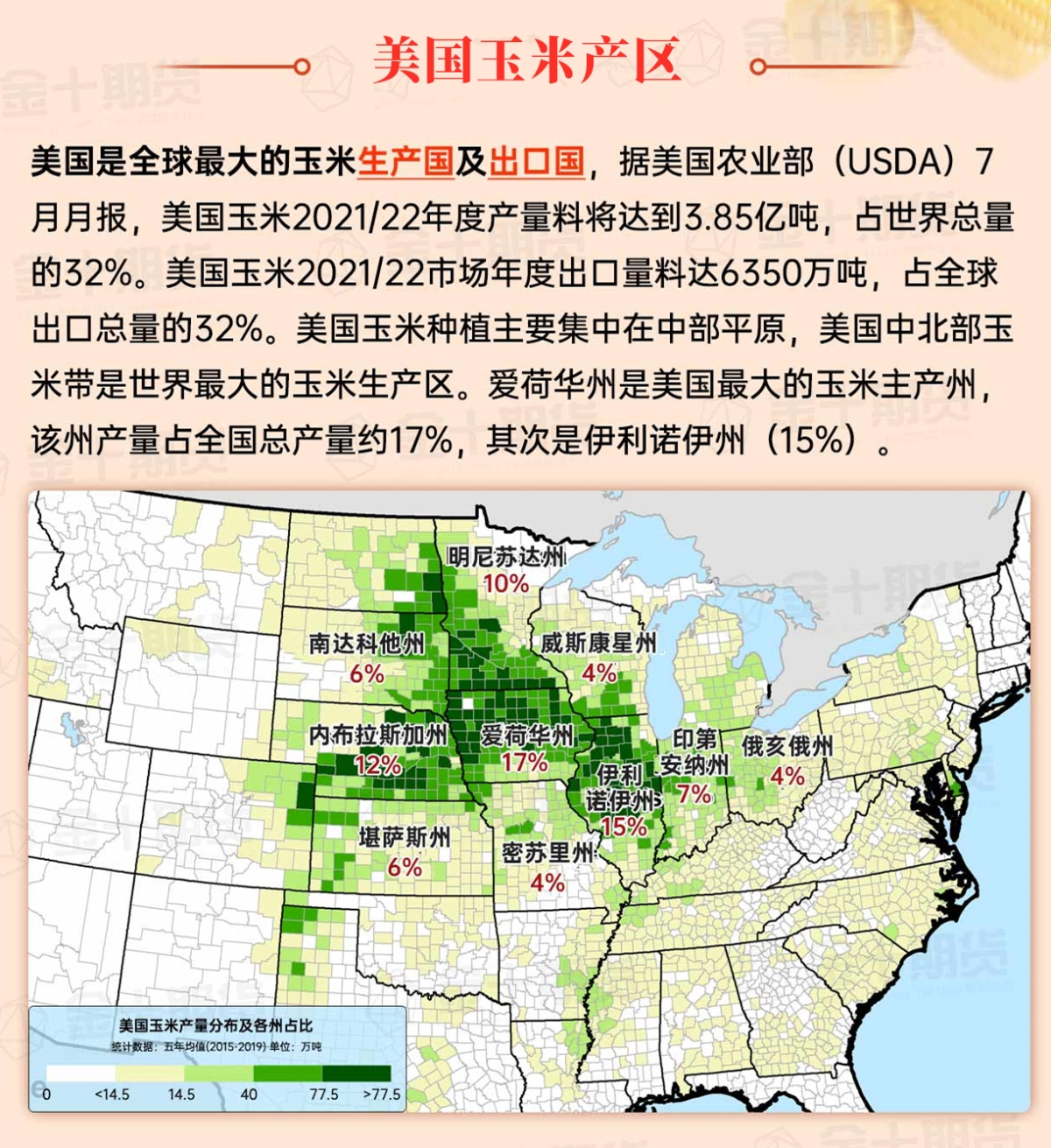
Corn Planting Area of the United States Showers and a few thunderstorms extend southwest from the Upper Midwest. At the same time, warm and mostly dry weather in the eastern corn belt is favorable for late-season corn and soybean planting, as well as winter wheat growth.
 Scattered showers extend from North Dakota to Colorado. The rain has caused a slight delay in wheat harvesting in the northern plains, but overall it has been beneficial for pastures, grasslands, and immature summer crops. The unstable weather separates the cool weather in the northern plains from the continued heat in the southeastern half of the region. Temperatures in the Eastern Washington and even to the north will approach 100 degrees Fahrenheit today.
Weather Outlook Initially, the active weather in most parts of the United States will eventually consolidate along the cold front sweeping through the central United States on Tuesday. Subsequently, the cold front will reach the coastal states along the Atlantic Ocean on Thursday, although cool and unstable showers will persist in the Great Lakes states for a few days. According to preliminary reports, the United States will breathe a sigh of relief from the continuous thunderstorms that triggered more than 500 tornadoes in May. Before calm weather arrives, precipitation in the eastern half of the United States may reach 1 to 3 inches, except in the southern hinterland. In addition, early heat waves will expand in the western United States this weekend, with maximum temperatures exceeding 110 degrees Fahrenheit and covering lower altitude areas in the desert southwest.
Warm but relatively calm weather still prevails, with a cold front weakening in the Ohio Valley and another cold front approaching the central and western regions. The initial cold front caused localized severe thunderstorms before weakening, with wind gusts exceeding 60 miles per hour in Lansing and Saginaw, Michigan, and Toledo, Ohio on August 28. However, some immature summer crops have benefited from scattered showers this week.
Map of US Corn Production Areas
Hot and humid weather continues to exist, especially from the Mississippi Delta region eastward. Today, the high temperatures in the northern Tennessee Valley will reach 100 degrees Fahrenheit or higher. Meanwhile, heavy rainfall over the Gulf of Mexico continues to move inland regularly, particularly along the coastal areas of Louisiana and Texas. These coastal rains have caused partial delays in crop harvesting, such as rice and other crops.
Chicago SRW Wheat and Corn Futures
In the western United States, a high-pressure ridge is gradually forming, resulting in mostly sunny and dry weather in most areas. As the weekend approaches, temperatures will gradually rise. By Sunday, temperatures may reach 100 degrees Fahrenheit and extend all the way to the eastern Washington. In some areas of the southwestern deserts, temperatures will exceed 110 degrees Fahrenheit. The dry weather will extend eastward to the northern plains. In the further eastern regions, unstable and rainy weather will gradually move southward, and the cold front currently approaching the central and western regions will continue to push towards the Gulf Coast. By Sunday, rainfall in the central and western regions will come to an end, while rainfall in the southern regions will form a west-to-east band distribution. In fact, rainfall in the southern regions will continue into next week, and many areas will see a total of 1 to 3 inches of rain over five days, with higher rainfall expected in southern Florida, Louisiana, and coastal areas of Texas.
The 6 to 10 day outlook from the National Weather Service from September 3rd to September 7th shows a higher likelihood of above-normal temperatures for the central and southern parts of New Mexico, extending to the line of the Great Lakes and northwestward. Abnormally hot weather will also prevail along the Gulf Coast and nearby areas, but in most areas, including the central and northern coastal regions of the Atlantic and most of the central and western regions, temperatures will be close to or slightly below normal. At the same time, most areas will have rainfall levels close to or slightly below normal, in contrast to the relatively moist conditions in most areas from most of Texas to the southern coastal regions of the Atlantic.
Soybeans should be translated as soybean.

The Atlantic Ocean should be translated as the Atlantic.

Cotton should be translated as cotton.


 零星的阵雨从北达科他州一直延伸到科罗拉多州。雨水导致北部平原地区的小麦收割稍有延迟,但总体上有益于牧场、草地和未成熟的夏季作物。不稳定的天气将北部平原的凉爽天气与该地区东南半部持续的高温分隔开。今天华盛顿东部甚至向北的高温将接近100华氏度。