
The 6 to 10-day outlook from the National Weather Service in the USA from September 2nd to September 6th indicates that there may be above-normal temperatures in the region stretching from western New Mexico to northwestern Minnesota, as well as along the Texas coast to the southern Atlantic coast.
Below is the exclusive compilation of the agricultural weather tips for Wednesday, August 28, 2024 in the USA by Jins. Futures APP.
Western United States Cool and rainy weather extends from the northwestern Pacific to the northern Rockies. This rain is beneficial for crops in the northwest, including winter wheat and small grains sown in the spring. At the same time, the hot weather in the Southwest is beneficial for farming and crop growth, although there is a high wildfire threat in some areas of Arizona and New Mexico.
The cool weather in the northern half of the region contrasts with above-normal temperatures from California to the southern Rockies. Except for localized showers in some southwestern areas, the weather conditions are mostly favorable for the maturation and harvest of summer crops. Washington is the only major spring wheat-producing region, and as of August 25th, its harvest work has been completed 75%, ahead of the average progress of 62% from 2019-2023, and ahead of the normal pace.
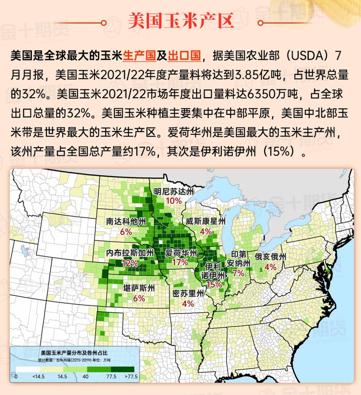
Corn Planting Area of the United States Showers and a few thunderstorms extend southwest from the Upper Midwest. At the same time, warm and mostly dry weather in the eastern corn belt is favorable for late-season corn and soybean planting, as well as winter wheat growth.
Apart from a few showers in Montana, dry weather is favorable for field work and crop growth. However, in drought-affected areas, immature summer crops continue to show varying degrees of stress. As of August 25th, 20% of sorghum and 28% of cotton in the US were rated as very poor to poor. On that day, cotton in Texas had the lowest rating, with 41% rated as very poor to poor.
Weather Outlook Initially, the active weather in most parts of the United States will eventually consolidate along the cold front sweeping through the central United States on Tuesday. Subsequently, the cold front will reach the coastal states along the Atlantic Ocean on Thursday, although cool and unstable showers will persist in the Great Lakes states for a few days. According to preliminary reports, the United States will breathe a sigh of relief from the continuous thunderstorms that triggered more than 500 tornadoes in May. Before calm weather arrives, precipitation in the eastern half of the United States may reach 1 to 3 inches, except in the southern hinterland. In addition, early heat waves will expand in the western United States this weekend, with maximum temperatures exceeding 110 degrees Fahrenheit and covering lower altitude areas in the desert southwest.
Showers and thunderstorms extending from the southern regions of the Great Lakes to the central Mississippi River provide beneficial moisture for the pollination of corn and soybeans, which have recently been affected by drought and brief hot weather. Currently, the cool air in the northern corn belt contrasts with the persistent high temperatures in the Ohio River Valley.
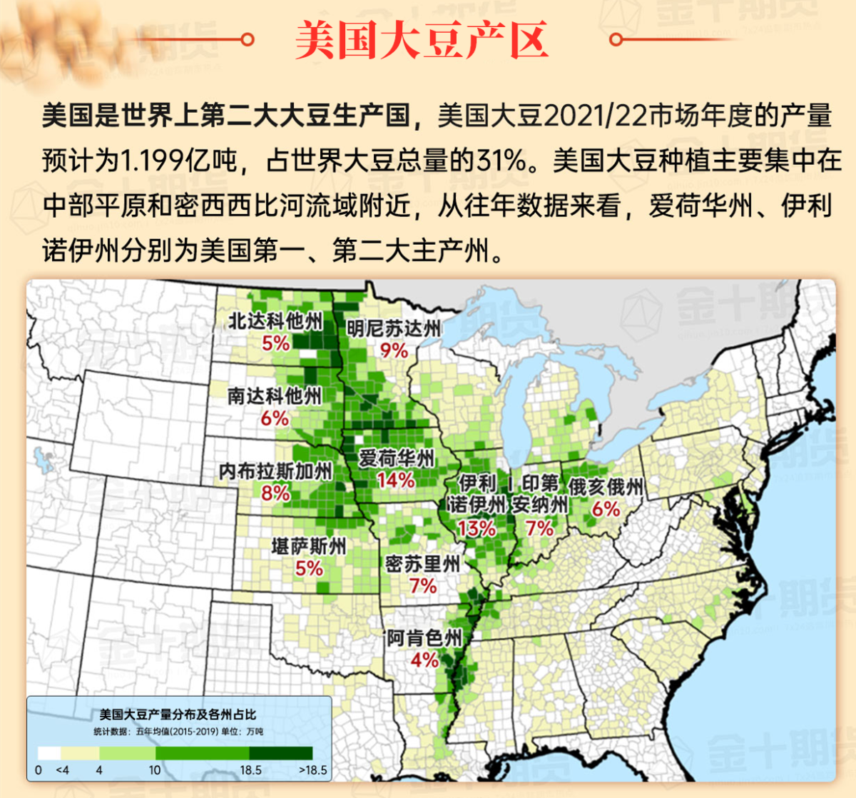
Map of US Corn Production Areas
The hot weather is moving eastward, mainly affecting the Mississippi Delta to the Atlantic southern coastal areas. The hot weather in the southeast promotes the maturity and harvest of summer crops, but puts pressure on ranches and immature crops. At the same time, there are showers in the western and central Gulf of Mexico coastal areas, with heavier rainfall mainly staying in offshore areas.
Chicago SRW Wheat and Corn Futures
The main weather features today include a pair of cold fronts crossing the northern United States and tropical moisture located in the southwest and Gulf of Mexico, which will affect the entire country from mid to late this week. For example, the cold front will focus on thunderstorm activity and bring a total of 1 to 2 inches or more of 5-day rainfall to many places from the southern Rockies to the upper Mississippi River areas. As the cold front interacts with tropical moisture, rainfall in the south will become more frequent. In fact, there may be heavy rain in southeastern Texas and southern Louisiana. On the other hand, the Pacific coastal states, the Great Basin, the western interior, and the northwest half of the Great Plains, except for northern Montana, will continue to remain dry in the next 5 days. In addition, the western dry areas will be accompanied by late-season high temperatures, while cool air will cover the central and western regions, the southern and eastern regions.
The 6-10 day outlook from September 2nd to September 6th by the National Weather Service shows that above-normal temperatures may occur in areas from western New Mexico to northwestern Minnesota and from the Texas coast to the southern Atlantic coastal areas. Below-normal conditions will cover the southern, central Atlantic, central and western regions, as well as the southeastern half of the Great Plains. Meanwhile, rainfall in the desert southwest and areas from the northern Great Plains to the northeastern regions may be below-normal, contrasting with above-normal rainfall in some areas from the northwest to the southern Rockies and the southern Atlantic coastal areas.
Soybeans should be translated as soybean.
The Atlantic Ocean should be translated as the Atlantic.
Cotton should be translated as cotton.
