
 稍微凉爽的天气取代了之前的炎热天气,预计今天北达科他州的最高气温将在75华氏度左右,而俄克拉荷马州东部及周边地区将接近100华氏度。此外,一条横穿该地区的阵雨带为牧场、草地和未成熟的夏季作物提供了有益的湿气。
The 6-10 day outlook from the National Weather Service of the USA from September 1st to September 5th shows that temperatures across the USA may be near or above normal levels.
The following is the agricultural weather forecast for Tuesday, August 27, 2024 in the United States, exclusively compiled by Atlantic China Welding Consumables, Inc.
Western United States Cool and rainy weather extends from the northwestern Pacific to the northern Rockies. This rain is beneficial for crops in the northwest, including winter wheat and small grains sown in the spring. At the same time, the hot weather in the Southwest is beneficial for farming and crop growth, although there is a high wildfire threat in some areas of Arizona and New Mexico.
A cold front is generating localized showers in the northwest Pacific. Meanwhile, the southwest monsoon circulation is causing showers in the southern Rocky Mountains. In between the rainy areas, mild and dry weather is favorable for the maturation and harvesting of summer crops. As of August 25, nearly half (47%) of the spring wheat in the United States has been harvested.
Corn Planting Area of the United States Showers and a few thunderstorms extend southwest from the Upper Midwest. At the same time, warm and mostly dry weather in the eastern corn belt is favorable for late-season corn and soybean planting, as well as winter wheat growth.
 Slightly cooler weather has replaced the previous hot weather. It is expected that the highest temperature in North Dakota today will be around 75 degrees Fahrenheit, while eastern Oklahoma and surrounding areas will approach 100 degrees Fahrenheit. In addition, a band of showers crossing the region is providing beneficial moisture for pastures, grasslands, and immature summer crops.
Weather Outlook Initially, the active weather in most parts of the United States will eventually consolidate along the cold front sweeping through the central United States on Tuesday. Subsequently, the cold front will reach the coastal states along the Atlantic Ocean on Thursday, although cool and unstable showers will persist in the Great Lakes states for a few days. According to preliminary reports, the United States will breathe a sigh of relief from the continuous thunderstorms that triggered more than 500 tornadoes in May. Before calm weather arrives, precipitation in the eastern half of the United States may reach 1 to 3 inches, except in the southern hinterland. In addition, early heat waves will expand in the western United States this weekend, with maximum temperatures exceeding 110 degrees Fahrenheit and covering lower altitude areas in the desert southwest.
Moisture from the tropical Pacific is contributing to showers and thunderstorms in the central and western Midwest. However, in the farther east, hot and dry weather is reducing soil moisture for corn pollination and soybean development. As of August 25, 11% of corn in the United States has reached full maturity, while 6% of soybeans are dropping leaves. During the week ending August 25, Ohio experienced extremely short to short topsoil moisture increase of 15-20% to 75%, Indiana 45%, Illinois 38%, and Michigan 31%.
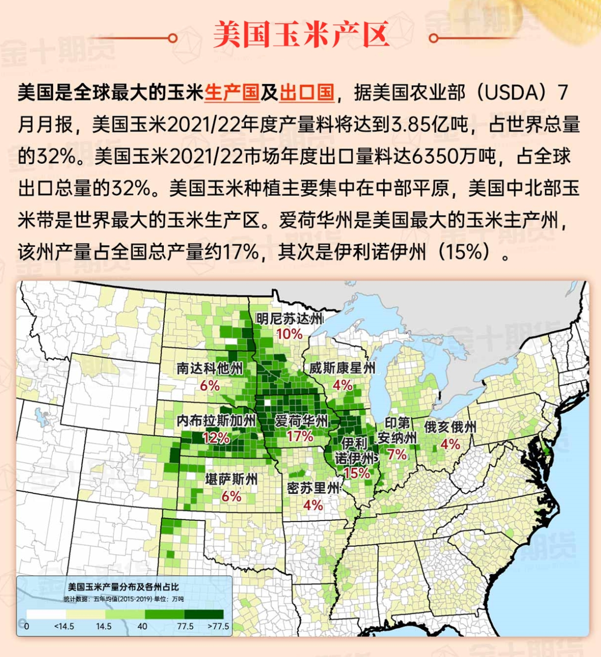
Map of US Corn Production Areas
The hot weather at the end of the season has promoted the ripening and harvesting of summer crops. As of August 25, the harvest of rice in the United States has reached 33%, far exceeding the 18% 5-year average. Later today, high temperatures in the Mississippi Delta and surrounding areas are expected to approach or reach 100 degrees Fahrenheit. Showers in the south are scattered and limited to the Gulf of Mexico and nearby areas.
Chicago SRW Wheat and Corn Futures
Active cold fronts interacting with the southwest monsoon circulation will produce scattered showers and thunderstorms for the remainder of the week. The total rainfall over the next five days could reach 1 to 3 inches, with some areas potentially higher, primarily in the eastern half of the United States, the Rocky Mountains, and the southern plains. Higher precipitation amounts may occur along the Gulf of Mexico and nearby areas in Texas, Louisiana, and southern Florida. Conversely, there will be little to no rainfall along the Pacific coast and northern high plains, except near the Canadian border. The western drought will continue with high temperatures, while a cold front will sweep through the southern, eastern, and central parts of the Midwest later this week.
The 6-10 day outlook from the National Weather Service for September 1-5 shows that temperatures across the United States may be near or above normal, except for cooler conditions from the central and northern Mississippi Valley to the northeast. Meanwhile, precipitation amounts in most of the northern United States and the southwestern desert areas may be near or below normal, in contrast to above-normal precipitation in the Pacific Northwest and surrounding areas, as well as the southern Rockies to the Atlantic coast.
Soybeans should be translated as soybean.
The Atlantic Ocean should be translated as the Atlantic.
Cotton should be translated as cotton.

