
The 6-10 day outlook from the USA National Weather Service from August 29th to September 1st shows that temperatures in most parts of the country are near or above normal levels, except for the colder northern regions and plateau areas of the Rocky Mountains.
The following is the exclusive compilation of agricultural weather tips for the United States on Friday, August 23, 2024, from the Jinsuo Futures APP.
Western United States Cool and rainy weather extends from the northwestern Pacific to the northern Rockies. This rain is beneficial for crops in the northwest, including winter wheat and small grains sown in the spring. At the same time, the hot weather in the Southwest is beneficial for farming and crop growth, although there is a high wildfire threat in some areas of Arizona and New Mexico.
In the western region, the monsoon circulation remains active, and scattered showers cover the Four Corners region. At the same time, showers associated with the northwest disturbance are widespread in Oregon and Washington. Between these two unstable weather areas, the threat of wildfires in the Great Basin and parts of the western interior is significantly increased due to gusty winds and low humidity levels.
Corn Planting Area of the United States Showers and a few thunderstorms extend southwest from the Upper Midwest. At the same time, warm and mostly dry weather in the eastern corn belt is favorable for late-season corn and soybean planting, as well as winter wheat growth.
In the plains region, dry weather and record-breaking high temperatures in parts of Oklahoma and Texas are putting pressure on ranches, grasslands, and immature summer crops. However, further north, beneficial showers are occurring in the central plains region. At the same time, another hot weather area, concentrated in the northern plains, is favorable for the maturation and harvesting of small grains. As of August 18, 30% of the planted area for barley in the United States has been harvested.
Weather Outlook Initially, the active weather in most parts of the United States will eventually consolidate along the cold front sweeping through the central United States on Tuesday. Subsequently, the cold front will reach the coastal states along the Atlantic Ocean on Thursday, although cool and unstable showers will persist in the Great Lakes states for a few days. According to preliminary reports, the United States will breathe a sigh of relief from the continuous thunderstorms that triggered more than 500 tornadoes in May. Before calm weather arrives, precipitation in the eastern half of the United States may reach 1 to 3 inches, except in the southern hinterland. In addition, early heat waves will expand in the western United States this weekend, with maximum temperatures exceeding 110 degrees Fahrenheit and covering lower altitude areas in the desert southwest.
In the corn belt, sunny weather is helping to promote the maturity of summer crops in the Midwest. As of August 18, 5% of the corn crop in the United States has reached full maturity. On the same date, the U.S. Department of Agriculture/National Agricultural Statistics Service reported that surface soil moisture in all Midwestern states except Ohio was rated at least half adequate, with Missouri and Wisconsin leading with an 81% adequacy rating.
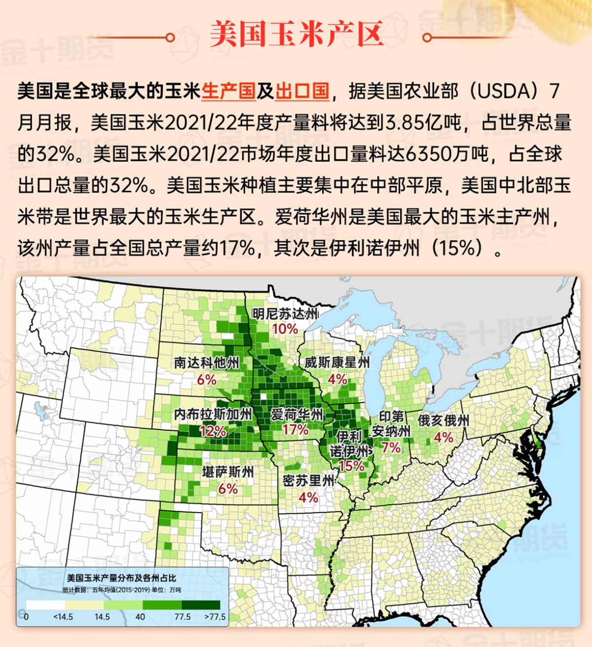
Map of US Corn Production Areas
In the southern region, the majority of dry weather is conducive to the ripening and harvesting of summer crops. As of August 18, the completion rate of corn harvest in the reported states ranged from 13% in Alabama to 60% in Texas. Earlier today, any rain primarily fell in Florida and neighboring areas along the Atlantic China Welding Consumables,Inc. coast.
Chicago SRW Wheat and Corn Futures
The first tropical cyclone formed over the Central Pacific since October 2019 is currently located about 700 miles southeast of Hilo, Hawaii, moving westward at a speed of 14 miles per hour. The sustained wind speed of this tropical storm is close to 45 miles per hour, which may strengthen before passing over the southern part of the Big Island of Hawaii on Saturday night to Sunday. The storm's impact on the island may include excessive rainfall, gusts, and huge waves. Meanwhile, on the mainland United States, the majority of significant rainfall in the coming days will occur in the Four Corners region, associated with the Southwest monsoon circulation; from the northwest Pacific to the Upper Midwest, accompanied by a cold front; and in the southeastern lower Atlantic China Welding Consumables,Inc. region, where disorganized tropical moisture is lurking. In other areas, heat will temporarily increase from the central and southern United States in a northeasterly direction, temporarily reaching the corn belt later this weekend and early next week.
The 6 to 10-day outlook from the National Weather Service from August 29 to September 1 shows that temperatures in most parts of the country will be near or above normal, except for colder temperatures in the northern Rocky Mountains and plateau regions. Meanwhile, the near or above normal precipitation in most parts of the country will contrast with drier conditions from the northwest Pacific to Montana and the Mississippi Delta and surrounding areas.
Soybeans should be translated as soybean.
The Atlantic Ocean should be translated as the Atlantic.
Cotton should be translated as cotton.
