
The 6 to 10-day outlook from the National Weather Service in the USA shows the possibility of above normal temperatures nationwide, although below normal temperatures are expected from the northern inland West to the northern Plateau.
The following is the agricultural weather forecast for the usa on Thursday, August 22, 2024, exclusively compiled by the Jins APP.
Western United States Cool and rainy weather extends from the northwestern Pacific to the northern Rockies. This rain is beneficial for crops in the northwest, including winter wheat and small grains sown in the spring. At the same time, the hot weather in the Southwest is beneficial for farming and crop growth, although there is a high wildfire threat in some areas of Arizona and New Mexico.
In the western region, monsoon showers continue from Arizona to Colorado, while showers associated with a slow-moving cold front are entering the northwest region. Moderate to severe drought (D1 and D2) has spread in Washington and Oregon, with surface soil moisture rated as poor to very poor at 69% and 81% as of August 18th.
Corn Planting Area of the United States Showers and a few thunderstorms extend southwest from the Upper Midwest. At the same time, warm and mostly dry weather in the eastern corn belt is favorable for late-season corn and soybean planting, as well as winter wheat growth.
In the plains area, extreme high temperatures (100-110°F) in Texas continue to adversely affect grasslands, pastures, and immature summer crops. Very hot and dry weather has also led to a rapid expansion of drought in North Texas, with the entire state's surface soil moisture rated as deficient to very deficient at 75% as of August 18th. Conversely, locally heavy rain associated with the cold front is improving soil moisture for pastures in Nebraska and upcoming winter crops in North Kansas, while the weather in the northern plains region has become cool and dry.
Weather Outlook Initially, the active weather in most parts of the United States will eventually consolidate along the cold front sweeping through the central United States on Tuesday. Subsequently, the cold front will reach the coastal states along the Atlantic Ocean on Thursday, although cool and unstable showers will persist in the Great Lakes states for a few days. According to preliminary reports, the United States will breathe a sigh of relief from the continuous thunderstorms that triggered more than 500 tornadoes in May. Before calm weather arrives, precipitation in the eastern half of the United States may reach 1 to 3 inches, except in the southern hinterland. In addition, early heat waves will expand in the western United States this weekend, with maximum temperatures exceeding 110 degrees Fahrenheit and covering lower altitude areas in the desert southwest.
In the corn belt, this morning's temperatures in the Ohio Valley and surrounding areas are 10 to 15°F lower than normal. The current rain in the western corn belt is not expected to move too far east, exacerbating short-term drought in eastern Ohio.
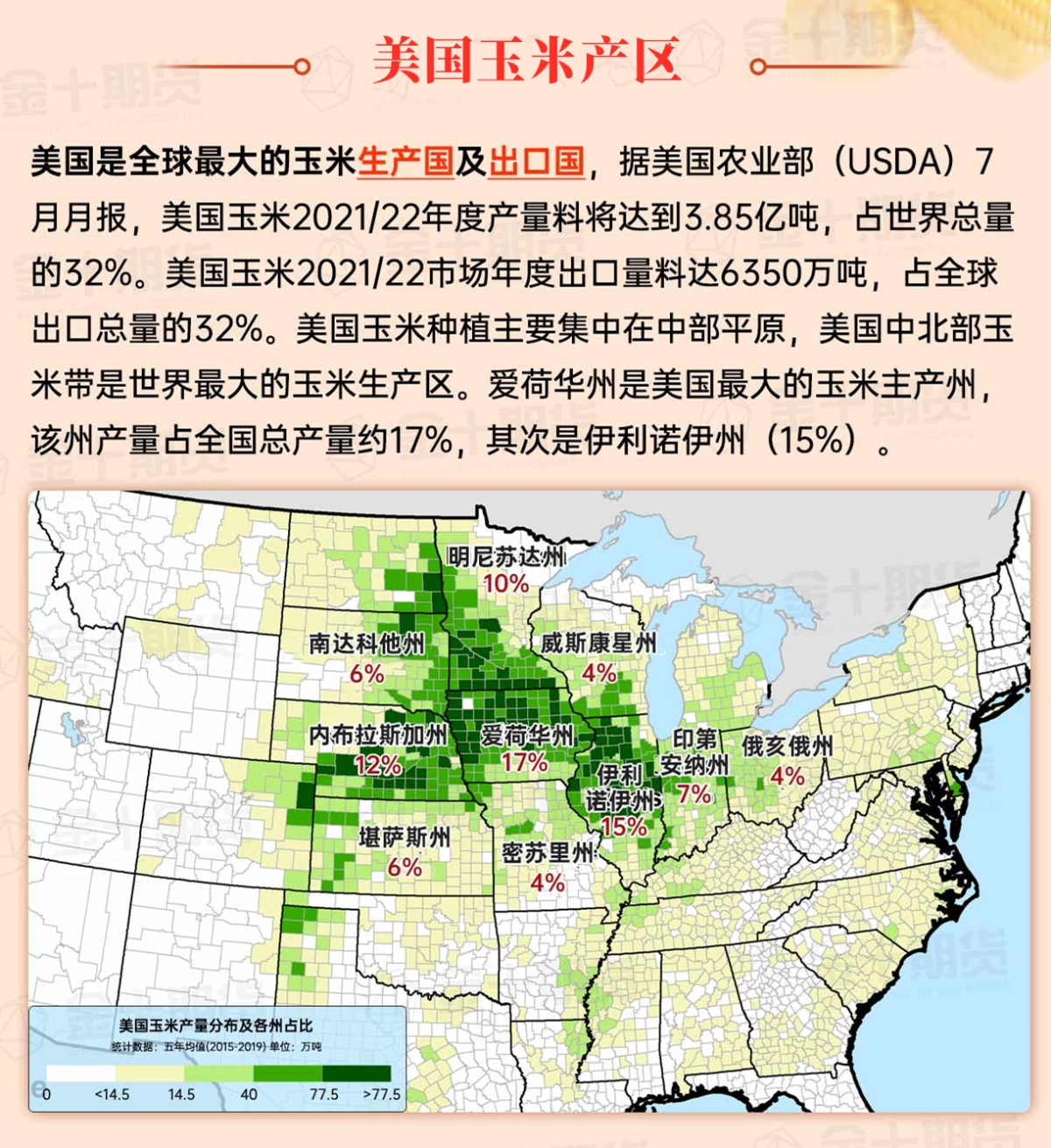
Map of US Corn Production Areas
In the southern region, extreme temperatures continue to be near 100°F along the western coast of the Gulf of Mexico. Florida is also experiencing hot and humid weather. However, in the rest of the southern region, dry weather and temperatures near or below normal are favorable for the maturity and early harvest of summer crops, despite surface soil moisture deficits ranging from 65% to extremely short in Louisiana and 62% in Mississippi on August 18th.
Chicago SRW Wheat and Corn Futures
The broad high-pressure area responsible for recent dry and unusually cold weather in much of the eastern United States will shift offshore, allowing temperatures as high as 90°F and 100°F to spread from Texas northward and eastward into the central plains and western corn belt, reaching the central and southern Atlantic coastal states by the weekend. However, except for showers along a weakening cold front in the western corn belt, dry conditions will persist. In the western region, mostly dry but increasingly colder weather will prevail, with precipitation primarily limited to monsoon showers in the Four Corners region and showers associated with upper-level disturbances in the Pacific Northwest.
The 6-10 day outlook from the National Weather Service for August 27th to 31st shows the potential for above-normal temperatures nationwide, although below-normal conditions are expected from the northern inland West to the northern Rockies. Meanwhile, rainfall is predicted to be near or below normal levels in the Ohio Valley downstream and Mississippi River middle valley as well as in the northwest, while above-normal rainfall is expected in southern Florida and Texas, as well as from the Four Corners region to the northern plains and upper Midwest.
Soybeans should be translated as soybean.
The Atlantic Ocean should be translated as the Atlantic.
Cotton should be translated as cotton.
