
The 6 to 10-day outlook from the US National Weather Service from August 25th to 29th shows that, except for below-normal temperatures in the northern Rockies, northern interior west, and northern plateau regions, temperatures in most parts of the country may be above normal.
Here are the United States' weekly agricultural weather tips for August 20, 2024, exclusively compiled by Jinshi Futures App.
Western United States Cool and rainy weather extends from the northwestern Pacific to the northern Rockies. This rain is beneficial for crops in the northwest, including winter wheat and small grains sown in the spring. At the same time, the hot weather in the Southwest is beneficial for farming and crop growth, although there is a high wildfire threat in some areas of Arizona and New Mexico.
In the western region, the weather is mostly dry, which is conducive to field operations, including grain harvesting in the northwest. As of August 18, only Idaho still had more than a quarter of winter wheat to be harvested (72% completed), but this progress still leads the 5-year average progress of 64%. At the same time, the spring wheat harvest progress in Washington State has exceeded half, and has completed 52% as of the 18th.
Corn Planting Area of the United States Showers and a few thunderstorms extend southwest from the Upper Midwest. At the same time, warm and mostly dry weather in the eastern corn belt is favorable for late-season corn and soybean planting, as well as winter wheat growth.
There are scattered showers near the warm front from Kansas to Dakota in the prairie region. High temperatures are returning to the plateau region, where the highest temperature today may reach 95°F or even higher, until eastern Montana. At the same time, most parts of Texas are still experiencing extreme heat (100°F or higher). As of August 18, Texas is leading the nation with 37% of cotton rated as very poor to poor, far higher than the national average of 26%.
Weather Outlook Initially, the active weather in most parts of the United States will eventually consolidate along the cold front sweeping through the central United States on Tuesday. Subsequently, the cold front will reach the coastal states along the Atlantic Ocean on Thursday, although cool and unstable showers will persist in the Great Lakes states for a few days. According to preliminary reports, the United States will breathe a sigh of relief from the continuous thunderstorms that triggered more than 500 tornadoes in May. Before calm weather arrives, precipitation in the eastern half of the United States may reach 1 to 3 inches, except in the southern hinterland. In addition, early heat waves will expand in the western United States this weekend, with maximum temperatures exceeding 110 degrees Fahrenheit and covering lower altitude areas in the desert southwest.
In the corn belt, cool and dry weather is dominant, and the highest temperature is generally between 70 and 80°F. Problems with slow crop development are mainly limited to the upper and middle western regions. As of August 18, only 64% of soybeans in North Dakota were podding, compared with a 5-year average of 84%. However, nationwide, 81% of soybeans are podding, close to the average of 80%.
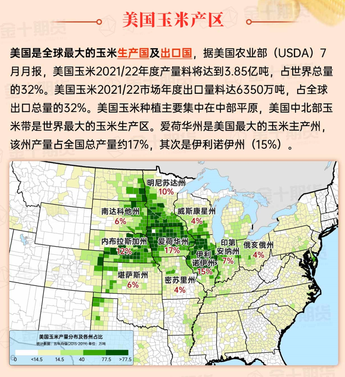
Map of US Corn Production Areas
In the south, a cold front spanning Florida and the northern Gulf of Mexico helps concentrate remaining showers. With the return of mostly dry weather, southern producers are monitoring an end-of-summer dry trend that as of August 18 has caused at least half of the surface soils in Texas (75%), Louisiana (65%), Mississippi (62%), Arkansas (53%), and Tennessee (50%) to be rated as very short to short.
Chicago SRW Wheat and Corn Futures
In the coming days, the weather in most parts of the United States will be relatively calm. It is noteworthy that dry weather will cover the southeastern United States until this weekend, except for the adjacent areas of the Florida Peninsula and the Atlantic coast as far north as coastal Carolina. The dry pattern will be accompanied by below-normal temperatures. Further west, a resurgence of the Southwest Monsoon circulation should bring showers to Texas, Colorado, Arizona, and New Mexico from Wednesday. The brief interaction between the monsoon and the cold front could enhance the showers activity in the mid-northern United States this week. Elsewhere, the central and southern United States will continue with hot and dry weather, while scattered but beneficial showers will continue to push northwest inland.
The 6-10 day outlook from the National Weather Service from August 25th to 29th shows that except for below-normal temperatures in the North Rockies, North Interior West, and North Plateau regions, most of the country may have above-normal temperatures. Meanwhile, most of the country's near-normal or below-normal rainfall amounts contrast with rainy weather from the North Rockies to the Upper Midwest and from southern Texas to the southern deep south.
Soybeans should be translated as soybean.
The Atlantic Ocean should be translated as the Atlantic.
Cotton should be translated as cotton.
