
The 6-10 day outlook from the US National Weather Service from August 21 to 25 shows that rainfall in most areas of the United States will be near or below normal levels.
The following is the US Agriculture Weather Tips for Friday, August 16, 2024, exclusively compiled by Golden Ten Futures App.
Western United States Cool and rainy weather extends from the northwestern Pacific to the northern Rockies. This rain is beneficial for crops in the northwest, including winter wheat and small grains sown in the spring. At the same time, the hot weather in the Southwest is beneficial for farming and crop growth, although there is a high wildfire threat in some areas of Arizona and New Mexico.
Warm and mostly dry weather is favorable for field work and crop development. However, a few showers are appearing in northern and surrounding areas of the Rocky Mountains. Due to dozens of active wildfires, air quality has declined in the northwest. Oklahoma and Texas are continuing to experience a heat wave. In Abilene, Texas, all days of this month except August 9th have reached high temperatures of 100°F (approximately 37.8°C) or higher. On August 11th, 42% of ranches and pastures in Texas were rated as very poor to poor, a six percentage point increase from the previous week. The high temperatures in the southern Great Plains have also had adverse effects on immature summer crops, including some cotton and sorghum.
Corn Planting Area of the United States Showers and a few thunderstorms extend southwest from the Upper Midwest. At the same time, warm and mostly dry weather in the eastern corn belt is favorable for late-season corn and soybean planting, as well as winter wheat growth.
Because of a low-pressure system over the Upper Great Lakes region and its accompanying cold front, showers and thunderstorms occur. Earlier today, some of the most severe showers occurred in the eastern corn belt. Because the surface soil moisture in the eastern corn belt of Ohio has become limited—rated very short to short at 40% shortage on August 11th and Indiana at 32%—rain is favorable for summer crops in the developmental filling stage.
Weather Outlook Initially, the active weather in most parts of the United States will eventually consolidate along the cold front sweeping through the central United States on Tuesday. Subsequently, the cold front will reach the coastal states along the Atlantic Ocean on Thursday, although cool and unstable showers will persist in the Great Lakes states for a few days. According to preliminary reports, the United States will breathe a sigh of relief from the continuous thunderstorms that triggered more than 500 tornadoes in May. Before calm weather arrives, precipitation in the eastern half of the United States may reach 1 to 3 inches, except in the southern hinterland. In addition, early heat waves will expand in the western United States this weekend, with maximum temperatures exceeding 110 degrees Fahrenheit and covering lower altitude areas in the desert southwest.
Hot and humid weather is particularly prevalent from the western Gulf of Mexico coastal areas to the Mississippi Delta. Despite the hot weather, producers are actively engaged in early season harvest activities for a variety of crops, including corn and rice. Meanwhile, some thunderstorms are entering northern parts of the region, including parts of Tennessee and Kentucky.
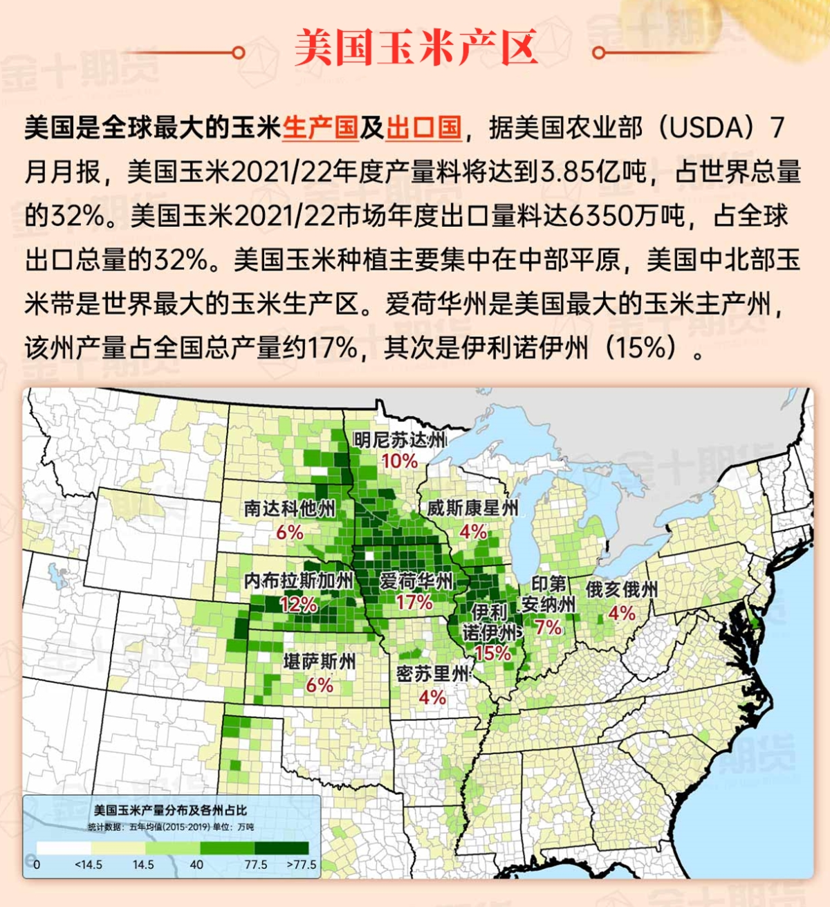
Map of US Corn Production Areas
The active weather associated with the cold front will continue to move eastward, arriving at coastal states of the Atlantic by late today through the weekend. Rainfall in the northeastern United States may temporarily intensify over the weekend, reaching a total of 1 to 3 inches or more. Meanwhile, northward-moving Hurricane Ernesto will remain more than 500 miles east of the US East Coast. In the western regions, a late summer heat wave will persist, leading to frequent high temperatures of more than 105°F (approximately 40.6°C) in parts of Texas due to a high pressure ridge centered over the Rocky Mountains and southern Great Plains. Hot and humid weather will continue along the Gulf Coast and its adjacent areas. However, cooler-than-normal weather will generally prevail in the Midwest. Substantial rainfall will be scarce in the Mississippi River West, despite a brief intensification of monsoonal-related showers in Arizona and Utah over the weekend.
Chicago SRW Wheat and Corn Futures
The US National Weather Service's 6-10 day outlook for August 21st to 25th projects temperatures above normal in the Plains, Rocky Mountains, Southwest, and southernmost regions, while below normal in the far western and from the Midwest Mississippi River Basin to the mid-Atlantic states. Meanwhile, precipitation for most of the country will be near or below normal, while above normal along the Atlantic coast and from the Pacific Northwest to the northern High Plains region.
The 6-10 day outlook from the US National Weather Service on August 21-25 shows that temperatures may be above normal in the Plains, Rocky Mountains, Southwest, and Deep South, while the far west and the region from the central Midwest Mississippi River basin to the mid-Atlantic states will be below normal. At the same time, rainfall in most of the US will be near or below normal, except along the Atlantic coast and from the northwest Pacific to the northern high plains region, where it will be above normal.
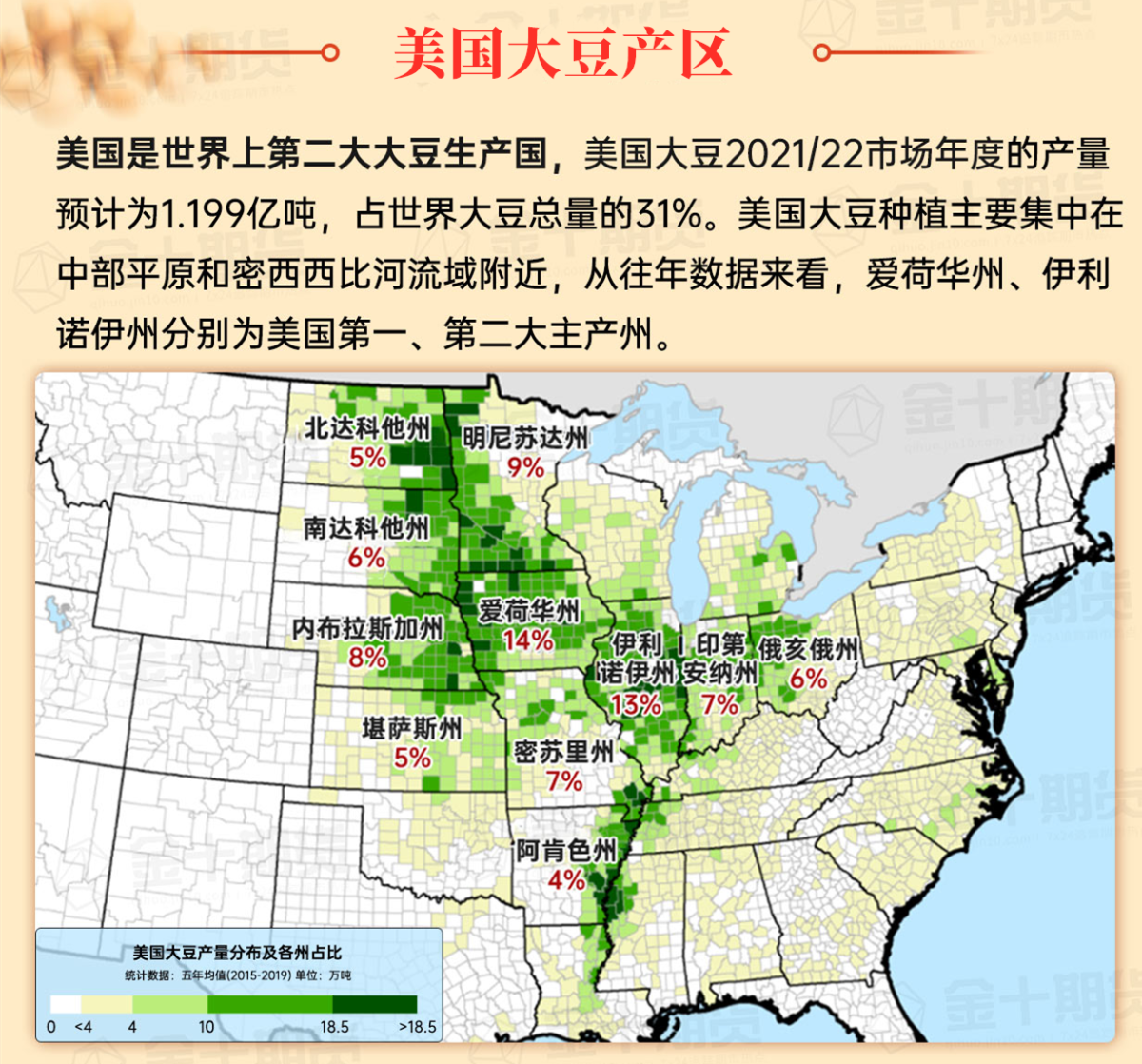
Soybeans should be translated as soybean.
The Atlantic Ocean should be translated as the Atlantic.
Cotton should be translated as cotton.
