
The 6-10 day outlook from the National Weather Service in the United States from July 23 to 27 shows that there may be near or below normal temperatures in the Pacific Northwest region and the vast area centered on the central and southern plains, the southern corn belt, and the central and southern regions.
The following is the US Agriculture Weather Tips for Thursday, July 18, 2024, exclusively compiled by Jinshi Futures APP.
Western United States Cool and rainy weather extends from the northwestern Pacific to the northern Rockies. This rain is beneficial for crops in the northwest, including winter wheat and small grains sown in the spring. At the same time, the hot weather in the Southwest is beneficial for farming and crop growth, although there is a high wildfire threat in some areas of Arizona and New Mexico.
With the continued midsummer heat wave, dry thunderstorms remain a threat to new wildfires. Later tonight, lightning may be particularly active in parts of the Great Basin and northern inland west. In Oregon, three fires have already burned over 50,000 acres of vegetation.
Corn Planting Area of the United States Showers and a few thunderstorms extend southwest from the Upper Midwest. At the same time, warm and mostly dry weather in the eastern corn belt is favorable for late-season corn and soybean planting, as well as winter wheat growth.
After the cold front, the main weather is dry. The heat wave in the southern prairie has ended, but significantly above-normal temperatures are occurring in northern highlands, including Montana. The hot and dry conditions in the northern highlands are conducive to the development of summer crops and the harvest of winter wheat.
Weather Outlook Initially, the active weather in most parts of the United States will eventually consolidate along the cold front sweeping through the central United States on Tuesday. Subsequently, the cold front will reach the coastal states along the Atlantic Ocean on Thursday, although cool and unstable showers will persist in the Great Lakes states for a few days. According to preliminary reports, the United States will breathe a sigh of relief from the continuous thunderstorms that triggered more than 500 tornadoes in May. Before calm weather arrives, precipitation in the eastern half of the United States may reach 1 to 3 inches, except in the southern hinterland. In addition, early heat waves will expand in the western United States this weekend, with maximum temperatures exceeding 110 degrees Fahrenheit and covering lower altitude areas in the desert southwest.
The high-pressure system centered on the upper Mississippi River brings cool, dry weather, and the highest temperatures in the Midwest today are expected to remain below 80°F. Although the upper Midwest is still humid, summer crops in the corn belt are generally in good condition, and warmer weather will benefit the growth of corn and soybeans.
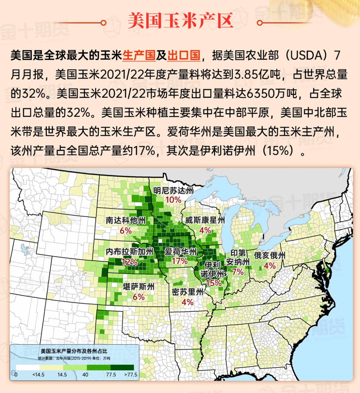
Map of US Corn Production Areas
The unstable and rainy weather continues from eastern Texas to the southern coast of the Mid-Atlantic. Before the rainfall this week on July 14, Virginia's pastures were rated 63% in very poor to poor condition, North Carolina was 55%, South Carolina was 47%, and Georgia was 41%.
Chicago SRW Wheat and Corn Futures
In the coming days, active thunderstorms will continue in the southern region, and total rainfall is expected to reach 2 to 6 inches from central and eastern Texas to the southern and Mid-Atlantic states over the next five days. However, dry weather is expected to persist in the Midwest, Upper Mississippi Valley, and Northeast until early next week. At the same time, some thunderstorms may occur in parts of the plains later in the weekend, with widespread distribution. In the west, as the possibility of thunderstorms decreases, the heat wave will intensify again, except in the southern Rocky Mountains, where the monsoon circulation will remain active.
The 6-10 day outlook from July 23 to 27 by the National Weather Service shows that the Pacific Northwest and the vast region centering on the central and southern plains, southern corn belt, and south-central United States may experience temperatures close to or below normal, while most of the northern and western regions and the Atlantic coast will experience hotter than normal weather. At the same time, near or above normal rainfall in most of the country should contrast with drier than normal climates in the northern highlands.
Soybeans should be translated as soybean.
The Atlantic Ocean should be translated as the Atlantic.
Cotton should be translated as cotton.
