
June 28, 2024.
NTT DATA Corporation
As part of its efforts to implement drones in society, NTT DATA Corporation (hereinafter referred to as NTT DATA) conducted a joint research with the Tokyo Metropolitan Agriculture and Forestry Promotion Foundation and the Tokyo Metropolitan Agriculture and Forestry Research Center that utilizes drones and AI to identify the habitat of plants that indicate areas unsuitable for the growth of cedar trees from October 2023 to April 2024. The project utilizes NTT DATA's knowledge in providing safe flying management systems for manned aircraft and is aimed at contributing to Tokyo's pollen reduction project by transplanting to cedar trees with less pollen. The operating income of products of 100-300 billion yen is respectively 401/1288/60 million yen.
The Tokyo Metropolitan Agriculture and Forestry Promotion Foundation is implementing a project to transplant cedar trees with less pollen in the Tama region as part of its pollen reduction efforts. The Tokyo Metropolitan Agriculture and Forestry Research Center is conducting research on healthy cedar growth by investigating specific plants that indicate areas unsuitable for cedar growth. However, the survey requires time and physical effort as it requires visual confirmation in steep mountain forests and steep slopes. There is also a risk involved in investigating steep slopes, and there are places where visual confirmation is difficult.
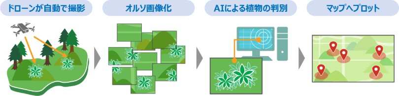
In this joint research, drones were first automatically flown to about 5 meters above the ground to take pictures of small plants, about 10 cm in diameter, at the site of the cedar transplantation project. High-quality orthophoto images that can identify the characteristics up to the way the leaves are attached were generated. Then, using AI software, a specific plant that indicates an area unsuitable for cedar growth was identified from multiple plants, and the results were mapped on a map software to create a "plant habitat map" and visualize the specific plant habitat at the site. This aims to reduce the time required to confirm the plants. During the survey, we also succeeded in two simultaneous drone flights to improve the efficiency of shooting by solving the problem of narrowing the shooting range due to low-altitude flight.Note 1Figure 1: Process of visualizing specific plant locations
Figure 1: Process of visualizing specific plant locations
It is expected that replacing the current manual survey with drones will greatly contribute to expanding the survey area, improving survey efficiency, and ensuring the safety of surveyors.
Overview
Implementation Overview
| Date and Time |
|
|---|---|
| Implementation location: Tokyo Metropolitan Agriculture and Forestry Promotion Foundation site, Hachioji City, Tokyo |
|
| Implementation contents: Take pictures of specific plants with drones, generate orthophoto images, identify the habitat using AI, and map it; two drones are flown automatically at the same time to cover a wide area |
|
| Using "airpaletteUTM" to manage drone operations, we successfully shot small plants from a height of 5 meters above the ground in mountainous areas with steep slopes, and generated orthophoto images that can identify small plants. Two drones were flown automatically at the same time to improve shooting efficiency. |
|
The use of drones is expected to have an impact on survey activities.
By utilizing drones to extract specific plants from aerial images and confirm their habitat, it is possible to contribute to reducing the labor required for surveys.
Area expansion.
It is possible to inspect steep slopes that were difficult to do manually, enabling accurate identification of habitat locations over a wider range.
Shortened time period.
Surveys can be conducted in a short time compared to searching manually.
Improvement of survey frequency.
Regular stationary observations are easily possible by using the flight route set once.
Reduction of risk.
There is no need to enter dangerous places such as steep slopes, reducing the risk of slipping.
Future Prospects
In the future, we will utilize the knowledge and achievements gained from this project and expand the types of plants targeted for survey and expand the survey area, and by analyzing them in combination with other data, we will proceed with verification to contribute to the development of forest conservation. We will also aim to contribute to a wider society by expanding this project.
Furthermore, we aim to contribute to a higher and wider society by expanding this project.
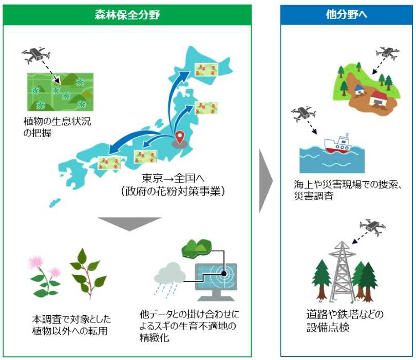
Figure 2: Future Outlook
Notes
- Note 1 Ortho images: An image obtained by converting an aerial photograph into an image (referred to as "orthographic transformation") that is displayed in the correct size and position, similar to a map, without shifting the position of the image in the photograph.
- Note 2 DF Scanner: A forest information analysis system developed and sold by DeepForest Technologies.
- "airpaletteUTM" is a registered trademark of NTT DATA Corporation in Japan.
- Other commodity ETF, company names, and group names are trademarks or registered trademarks of their respective companies.
For inquiries regarding this matter,
NTT DATA Corporation
Digital Community Business Division.
Sato, Masunaga, and Shinohara.
E-mail:tmgdrone@hml.nttdata.co.jp