
The US National Weather Service's 6-10 day forecast from May 22 to 26 predicts that rainfall is likely to be close to or above normal in most parts of the US.
The following are US agricultural weather tips for Friday May 17, 2024, compiled exclusively by the Jin10 Futures App
Western US region
The warm, dry weather has accelerated field work and crop development in the central and southern regions. In contrast, the northern Rockies and the Northwest are accompanied by rain and snowfall in the mountains, where temperatures are much lower. Western droughts have been largely eliminated by the second consecutive year of abnormally humid water, but as of May 12, Montana and Arizona surface soil moisture levels were rated at 60% and 91%, respectively, as of a shortage to very scarce.
American Plains
Much of the dry weather in the central and southern regions promoted field work and the development of winter wheat. However, there are still sporadic showers in North Texas, and the Northern Plains region is also dotted. The drought continues to affect winter wheat in Kansas, where 35% of the state's crops were rated poor to very poor as of May 12.
American corn growing belt
Showers again occurred in Ohio and the Central Mississippi Valley, and there was also some sporadic light rain in the upper Midwest. Newly arrived wetness further delayed field work; as of May 12, the area under corn cultivation in Illinois was 42%, 14 percentage points behind the 5-year average, and 39 percentage points behind the same period last year.
Southern region of the United States
Showers and thunderstorms — some severe — are spreading to the eastern Gulf Coast region and reinvigorating southern Texas. The rain will continue to slowly move eastward through the southeast on Friday, although South Florida will remain mostly clear and hot.
Weather outlook
After a slow-moving storm leaves the Mid-Atlantic coast, another disturbance in the southern plains will drift northeast and maintain or reintroduce showers and unusually cool weather in the Mid-Atlantic, Lower Ohio Valley, and the Southeast, even though Florida continues to be hot. Furthermore, a subtropical air mass would maintain the risk of heavy rain and flash floods along the Gulf Coast. Further north and west, a weaker cold front will cause rain and mountain snowfall as it crosses the central Rockies, the Great Plains, and the Upper Midwest, but a strengthened cold front will follow, renewing the chance of rain in the same area later in the weekend. By early next week, a second storm will separate the abnormally cold temperatures in the northwestern United States from the summer-like heat of the central and southern plains.
The US National Weather Service's 6-10 day forecast for May 22-26 predicts that rainfall is likely to be close to or above normal in most parts of the country, while drier than normal conditions are limited to the southern Rocky Mountains and the southernmost tip of Texas and Florida. Temperatures are expected to be warmer than normal from Texas to the east coast, and colder than normal from the upper Midwest through the Northern Plains, the Mid-North Rocky Mountains, and Pacific Rim states.
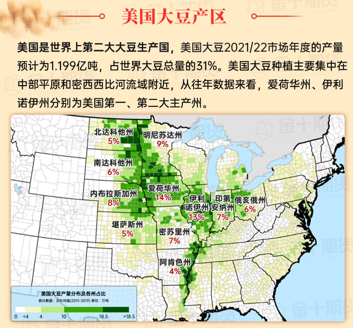
Map of soybean growing regions in the United States
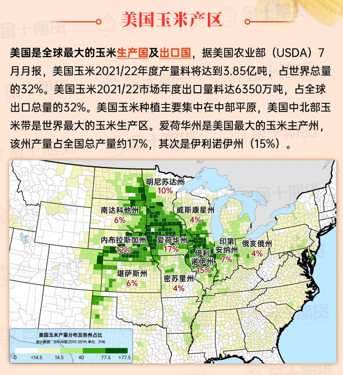
Map of corn growing regions in the United States
Map of cotton growing regions in the United States
